
Stations
 button in the upper left of the map window. (You may need to turn off layers to select other objects underneath.) Map shapes and icons are provided for reference only, precise locations may vary.
![]() To find out what we're working on in 2022, click on the tabs to expand the information!
To find out what we're working on in 2022, click on the tabs to expand the information!
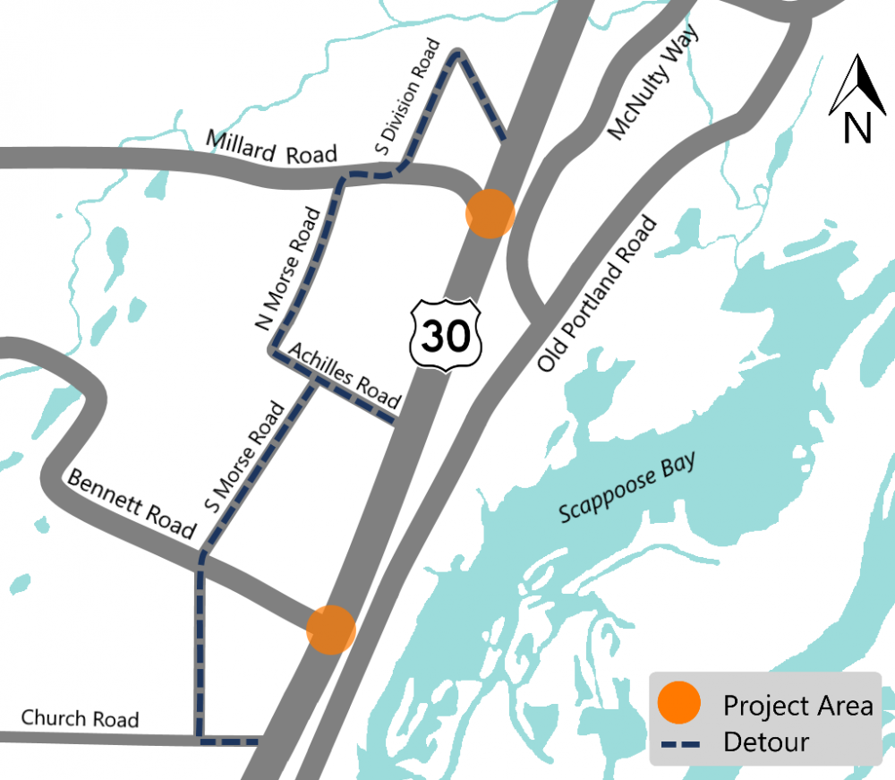
U.S. 30 Safety Project
About
We are working on improving the safety of U.S. 30 between Scappoose and St. Helens by:
-
Widening and restriping the roadway near the U.S. 30 and Bennett Road intersection to increase the space for vehicles making right turns.
-
Creating a median on U.S. 30 to restrict left turns from Bennett Road onto U.S. 30.
-
Adding a traffic signal at the intersection of U.S. 30 and Millard Road.
-
Widening Millard Road to create protected turn lanes onto U.S. 30.
-
Upgrading the rail crossings at both Millard and Bennett Roads. This work is being completed by the railroad.
Schedule
We started construction in 2021 anticipate completing construction in 2022.
Impacts
Expect to see crews working Monday through Friday, from 6 a.m. to 5 p.m. with lane closures and delays. Occasional weekend work will be occurring for railroad work. Hard barrier will be in place at various locations through the completion of the project. Currently the east side of Millard Road is closed through July for rail work.
There may be night work as needed as the project progresses. Work is happening in stages as our contractor coordinates with utility partners and the railroad contractor. Some of the work we are doing needs to happen after the rail work is completed, including the final paving of the project area.
Stay Connected
You can learn more about the project by visiting the project webpage. If you'd like to receive the most up to date information on this project, sign up to receive email alerts about news and updates for the U.S. 30 St. Helens and Scappoose area! When construction starts again, visit TripCheck.com for real time information on traffic and impacts.
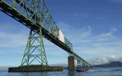
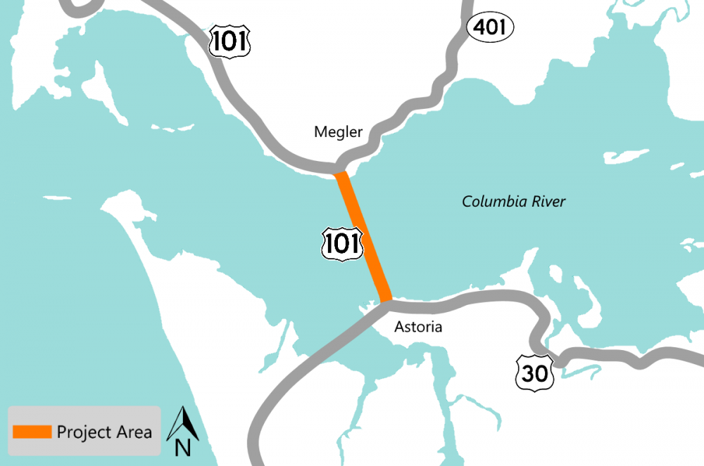
U.S. 101 Columbia River (Astoria-Megler) Bridge Painting
About
The Astoria-Megler Bridge is a multi span bridge over four miles in length. The bridge was built in 1966. We are doing some work that is necessary for the health and longevity of the bridge. Work includes:
-
Removing the original paint that may contain lead.
-
Painting under the bridge deck.
-
Repairing damaged steel.
-
Making other repairs as needed.
Schedule
We started construction in 2021 and anticipate completing construction by the end of 2024.
Impacts
Expect loud noises associated with preventing birds from entering the construction area. There is single lane closures Monday through Thursday from 6 a.m. to 7 p.m. and Friday from 6 a.m. to 5 p.m. with flaggers and up to 20 minute delays. Our crews will mostly work during those hours. However, when working on the southern part of the bridge that connects to U.S. 30, our contractor will be restricted to Sunday night through Friday morning from 7 p.m. to 6 a.m.
Drive through the area with caution.
Stay Connected
You can learn more about the project by visiting the project webpage. If you'd like to receive the most up to date information on this project, sign up to receive email alerts about construction updates for the area! Visit TripCheck.com for real time information on traffic and impacts.
U.S. 26 at Mendenhall Creek
About
We are replacing the existing culvert with a bridge. The new bridge will create an easier passage for native migratory fish like salmon and steelhead, some of which are listed as endangered species. Improving fish passages aligns with our commitment to the Oregon Plan for Salmon and Watersheds.
We are:
-
Removing the old culvert.
-
Installing a new concrete deck single span bridge.
-
Reconstructing the streambed to encourage native fish migration.
Impacts
Construction is underway and estimated to complete in 2023. Expect construction noise and short delays. We will maintain two lanes of traffic during construction.
Stay Connected
You can learn more about the project by visiting the project webpage. If you'd like to receive the most up to date information on this project, sign up to receive email alerts about construction updates for the area!
U.S. 30 Graham Creek Fish Passage
About
We are replacing the existing culvert with a new one for easier passage for native migratory fish like salmon and steelhead, some of which are listed as endangered species. Improving fish passage aligns with our commitments to the Oregon Plan for Salmon and Watersheds.
We are:
-
Removing the old culvert.
-
Installing a new culvert.
-
Reconstructing the streambed to encourage native fish migration.
-
Making roadway and guardrail repairs.
-
Striping within the project limits.
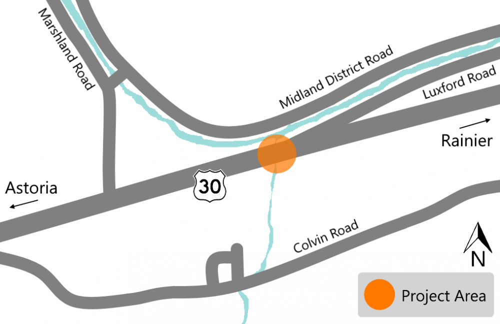
Impacts
This project is delayed. We anticipate construction starting in Spring 2023. When construction starts, expect lane closures and delays up to 20 minutes. We will maintain two way traffic will during construction. The project will be done in stages to make sure that freight and passenger vehicles can be accommodated.
Stay Connected
You can learn more about the project by visiting the project webpage. If you'd like to receive the most up to date information on this project, sign up to receive email alerts about construction updates for the area!
OR 47 Nehalem River Bridge Repairs
About
The Nehalem River Bridge is a historic bridge built in 1939 on OR 47 that needs to be repaired. These repairs are needed or the bridge will continue to deteriorate and require costly maintenance.
We are:
-
Removing the rust that has built up between the steel plates.
-
Straightening bent steel beams.
-
Replacing rusted rivets and bolts.
-
Repainting the bridge to protect the bridge against the elements and future rust.
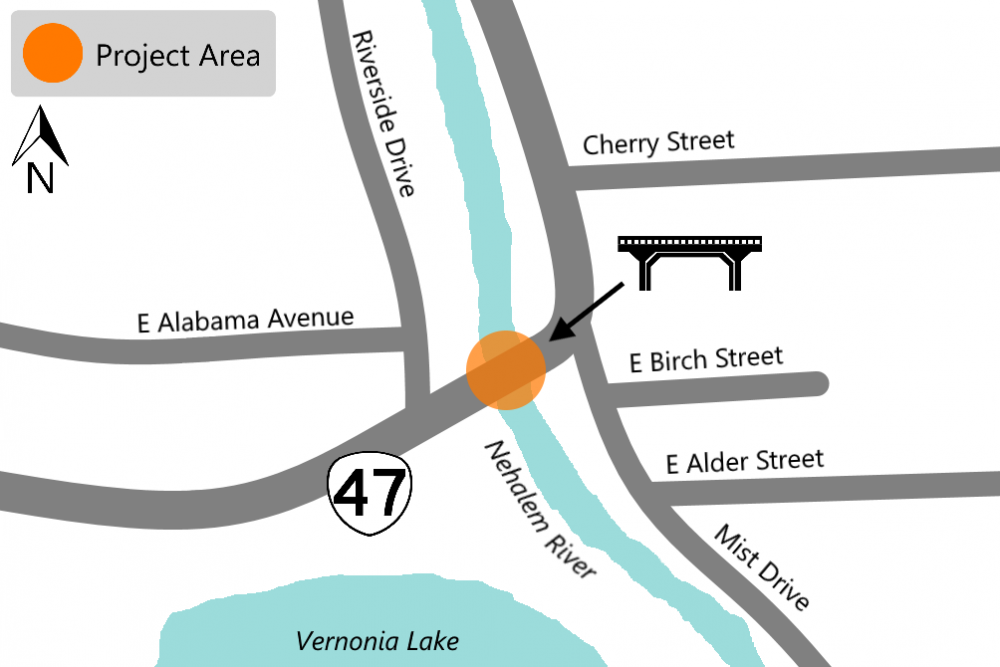
Impacts
Construction is underway. Expect noise and lane closures which will cause short delays. Traffic on the bridge will have intermittent single lane closures, controlled by flaggers through October.
Stay Connected
You can learn more about the project by visiting the project webpage. If you'd like to receive the most up to date information on this project, sign up to receive email alerts about construction updates for the area!
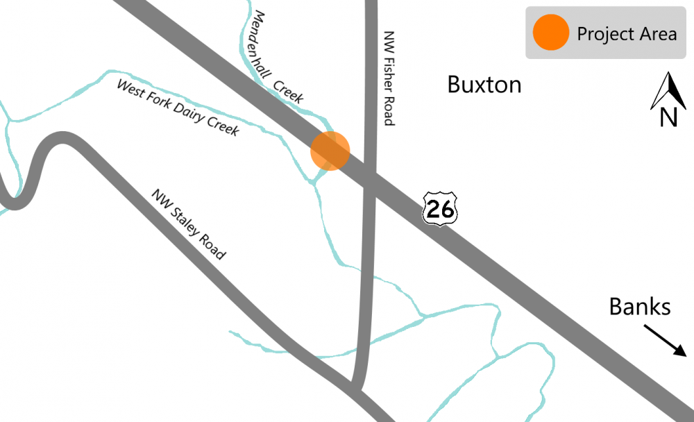
OR 47 West Fork Dairy Creek Bridge Replacement
About
The project is located at West Fork Dairy Creek on OR 47 west of Banks. The existing bridge is currently more than 80 years old and its timber deck is in poor condition. We are replacing the deteriorated timber bridge with a new single span bridge. We are also realigning the creek to prevent downstream bank erosion by adding vegetation and boulders along the sides of the creek.
We are:
-
Replacing the bridge and repaving the roadway.
-
Replacing guardrail.
-
Installing new striping.
-
Making improvements to help prevent erosion.

Impacts
Construction is underway, expect noise and no through access on OR 47. Replacing the bridge requires a full road closure of OR 47 from NE Banks Road to just north of the Dairy Creek Bridge. We estimate the road to be closed until October. During the closure, you can take the signed detour route using U.S. 26 and OR 6.
Stay Connected
You can learn more about the project by visiting the project webpage. If you'd like to receive the most up to date information on this project, sign up to receive email alerts about construction updates for the area!
Installing Curve Warning Signs on U.S. 101, U.S. 30 and U.S. 26
About
Over 50% of Oregon's curve warning and curve advisory speed signs don't meet the current national standards. This is because of outdated technologies used in initial curve analysis, changes in driving habits, improvements in vehicle safety features and inconsistent curve advisory speed changes that have happened over the past several decades. By upgrading and installing new signs, we are creating a safer road system with consistent curve advisory speeds and signs that meet the national standards.
We are:
-
Replacing and adding new signs at locations along U.S. 101 from milepost 0 to 167.
-
Replacing and adding new signs at locations along U.S. 30 from milepost 18.4 to 99.4.
-
Replacing and adding new signs at locations along U.S. 26 from milepost 0 to 45.4.
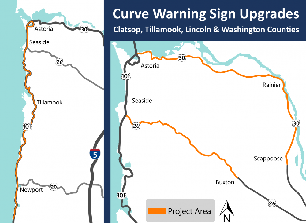
Impacts
Construction is underway. Expect shoulder and lane closures that may cause delays up to 20 minutes. The work zone will be controlled by flaggers. TripCheck.com will have the latest impacts.
Stay Connected
You can learn more about the project by visiting the project webpage. If you'd like to receive the most up to date information on this project, sign up to receive email alerts for the north coast and Willamette Valley!
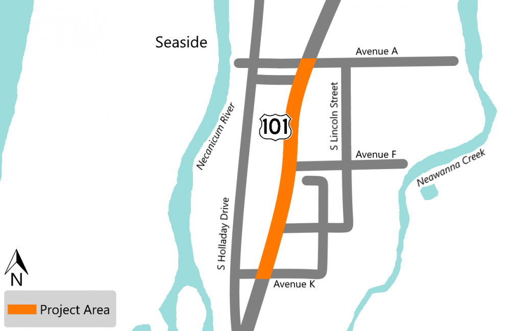
U.S. 101 Avenue A - Avenue K Improvements
About
We are making improvements to U.S. 101 in Seaside from Avenue A through Avenue K for all road users whether you walk, ride or roll!
We are:
-
Installing a new center turn lane.
-
Improving bicycle and pedestrian facilities.
-
Installing two rectangular rapid flashing beacon crosswalks, the first is between Avenue A and Avenue B and the second is at Avenue F.
-
Installing median refuge islands between Avenue A and Avenue B and also at Avenue F, creating a place for people to wait until it is safe to cross.
-
Painting solid white line to encourage drivers to stop further back from the crosswalk between Avenue A and Avenue B and also at Avenue F.
-
Installing new curb ramps to ADA standards.
-
Upgrading traffic signs.
-
Improving drainage.
-
Replacing pavement and applying new striping.
Impacts
Construction will start in late 2022 and is estimated to complete in 2024. When construction starts, expect nightwork with lane closures, delays with the work zone controlled by flagging.
Stay Connected
You can learn more about the project by visiting the project webpage. If you'd like to receive the most up to date information on this project, sign up to receive email alerts about construction in the area!
U.S. 101 Paving Project
About
We are making road repairs and paving U.S. 101 from Ecola Creek by Cannon Beach to Arcadia Beach, north of Arch Cape to give road users a smoother ride.
We are:
-
Repaving the roadway.
-
Replacing guardrail.
-
Repairing the bridge decks.
-
Installing new bridge rail.
-
Upgrading traffic signs.
-
Applying new permanent striping.
-
Installing rumble strips.
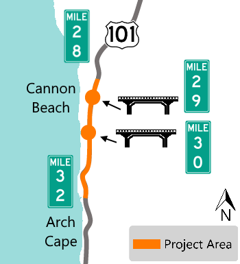
Impacts
Construction is underway. We're working during the day and at night. Expect lane closures and noise. Once paving starts, work will be done at night utilizing lane closures with flaggers and pilot cars. Night time work hours are Sunday evening through Friday morning, 7 p.m. - 7 a.m.
The bridge locations are narrowed with temporary concrete barriers installed and temporary striping to guide the open lanes around the work zone. There isn't northbound or southbound shoulder access for pedestrians and bicyclists.
Stay Connected
You can learn more about the project by visiting the project webpage. If you'd like to receive the most up to date information on this project, sign up to receive email alerts about construction updates for the area!
U.S. 101 Youngs Bay Bridge to Neptune Drive
About
We are resurfacing, restoring and rehabilitating a section of U.S. 101 from New Youngs Bay Bridge at milepost 5.3 to Neptune Drive at milepost 6.8.
We are:
-
Replacing guardrail.
-
Upgrading traffic signs.
-
Applying new striping.
-
Replacing signal loops.
-
Replacing a signal pole at the intersection of U.S. 101 and Neptune Drive for northbound traffic.
-
Making ADA upgrades.
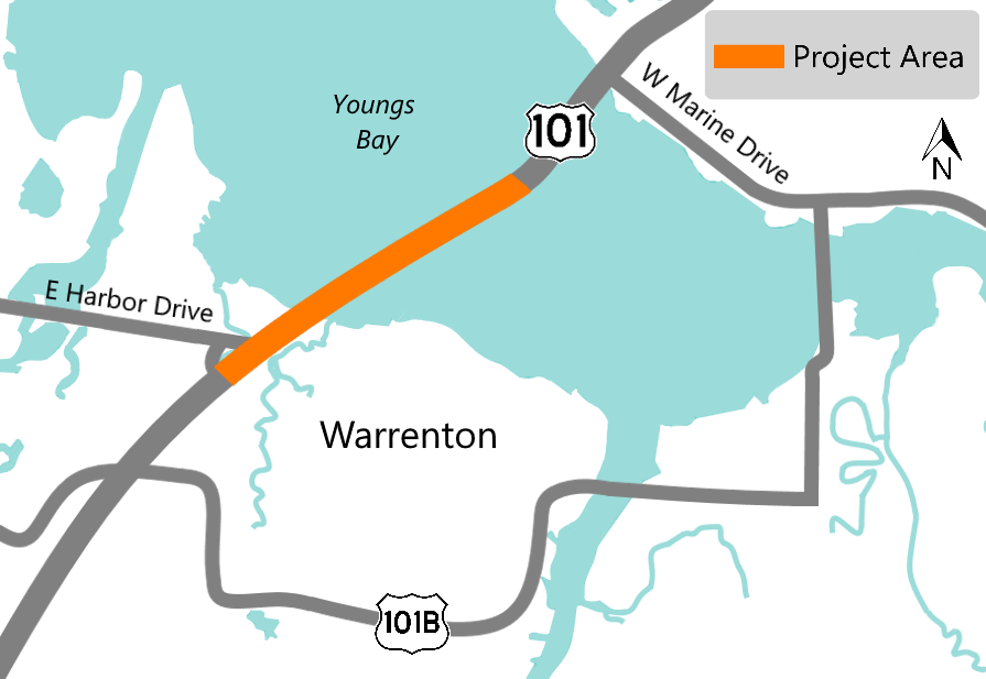
Impacts
Construction is underway, expect lane closures with flaggers helping direct traffic.
Through July 15 there will be a full, nightly closure of U.S. 101 from 8 p.m. to 5 a.m. for paving activities, a detour will be in place.
Stay Connected
You can learn more about the project by visiting the project webpage. If you'd like to receive the most up to date information on this project, sign up to receive email alerts about construction updates for the area!
U.S. 101 Perkins Lane Intersection
About
The intersection of U.S. 101 and Perkins Lane in Warrenton has frequent and severe crashes, most of which are caused by cars turning. We are making safety improvements to help reduce the potential and severity of the crashes.
We are:
-
Installing a left turn lane.
-
Installing a concrete separator.
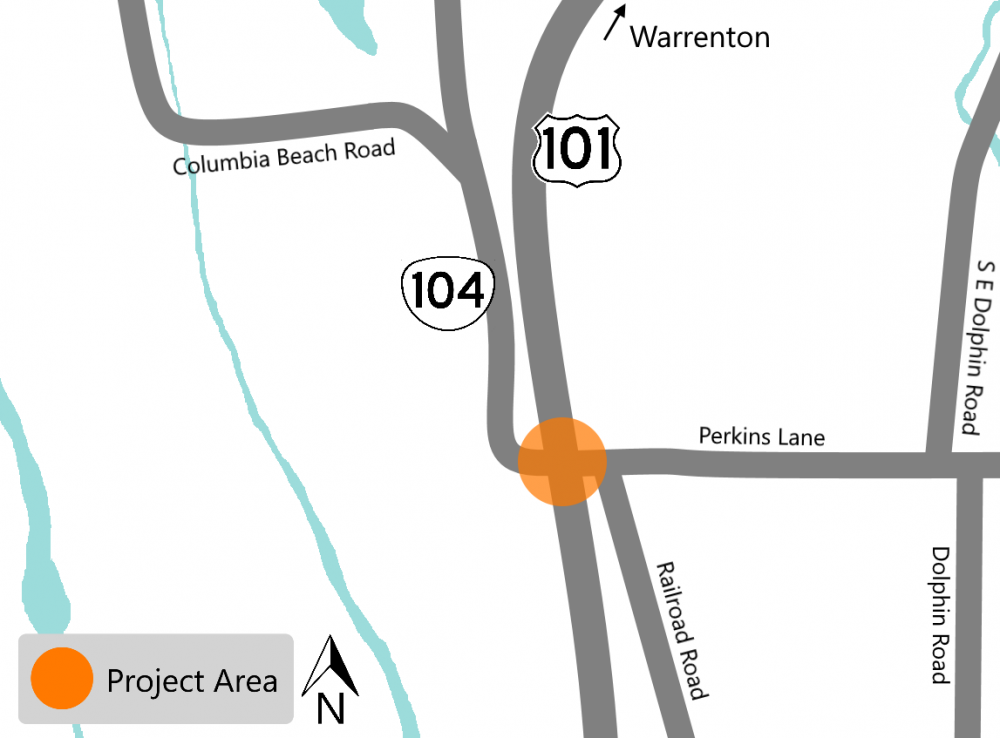
Impacts
Construction is underway, expect noise, possible shoulder and lane closures with travel delays. Work is being done during the day time.
Stay Connected
You can learn more about the project by visiting the project webpage. If you'd like to receive the most up to date information on this project, sign up to receive email alerts about construction updates for the area!
Do you have questions, comment or concerns?
Please let us know by filling out the form below.
![]() To find out what we're working on in 2022, click on the tabs to expand the information!
To find out what we're working on in 2022, click on the tabs to expand the information!
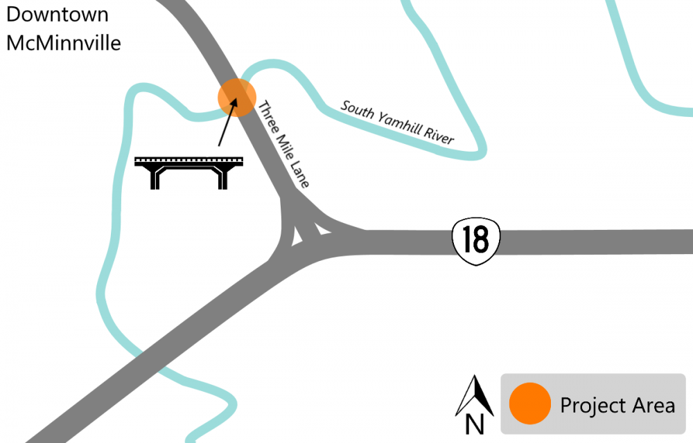
OR 18 Spur South Yamhill River Bridge Replacement
About
We are continuing work to replace the South Yamhill River Bridge that was built in 1951 and is in poor condition. This year we are working on building a temporary bridge to divert traffic while we build the permanent bridge.
In 2022 and 2023 we are:
-
Building the connections from the road to the temporary bridge.
-
Rerouting traffic and pedestrians to start using the temporary bridge.
-
Removing the existing bridge.
-
Constructing the new bridge.
In 2024 we are finishing building the new bridge and rebuilding the connections to the road. The new bridge will replace the existing 35 foot wide bridge with a wider 48 foot wide bridge and will be easier for large trucks, bicycles and pedestrians to use.
Schedule
We started construction in 2021 and anticipate completing construction by the end of 2024.
Impacts
Our crews have already constructed a temporary bridge for traffic to use while we remove the existing bridge. Expect short delays and intermittent lane closures with flaggers between 9 a.m. to 3 p.m. Monday through Friday, for material and equipment delivery.
Stay Connected
You can learn more about the project by visiting the project webpage. If you'd like to receive the most up to date information on this project, sign up to receive email alerts about construction updates for the area! Visit TripCheck.com for real time information on traffic and impacts.
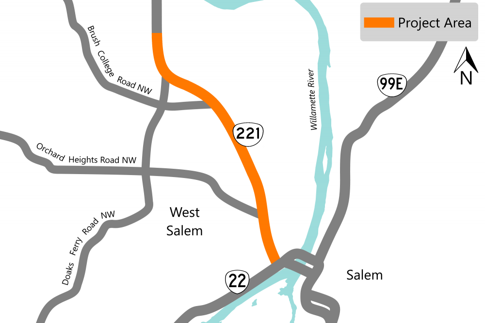
OR 221 Michigan City Lane to Edgewater Street
About
We are making a series of improvements on OR 221, Wallace Road, from Michigan City Lane to Edgewater Street to make the area safer whether you walk, ride or roll!
We are:
-
Repaving the project area.
-
Upgrading the curb ramps to meet current ADA standards.
-
Upgrading traffic signals with yellow reflective backplates to improve driver visibility.
-
Installing rapid flashing beacons and other improvements at five crosswalks: Narcissus Court NW, Lynda Lane NW, Orchard View Avenue NW, the Park and Ride north of Brush College Road and Vick Avenue NW.
Schedule
We started construction in 2021 and anticipate completing construction by the end of 2022.
Impacts
Expect delays and one lane of traffic in each direction during the daytime. Please be aware that the speed in the work zone has been reduced from 45 mph to 40 mph. We may be constructing more than one area at the same time. We don't plan to have any full road closures, expect single lane closures with flagging. Paving will be done at night this summer.
Stay Connected
You can learn more about the project by visiting the project webpage. If you'd like to receive the most up to date information on this project, sign up to receive email alerts about news and updates for the West Salem area! Visit TripCheck.com for real time information on traffic and impacts.
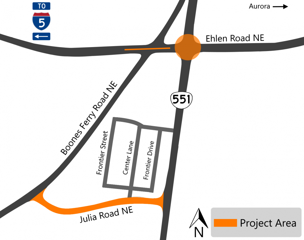
OR 551 at Ehlen Road Safety Project
About
We are making improvements to OR 551 to address the safety and operational issues.
We are:
-
Widening Ehlen Road to construct two dedicated left turn lanes approaching the OR 551 intersection, one for each direction of traffic.
-
Building a concrete traffic separator on OR 551 to prevent left turns from Boones Ferry Road onto OR 551 to help reduce congestion and make the intersection safer.
-
Constructing a new county road, named Julia Road NE, connecting Boones Ferry Road NE and OR 551 south of Ehlen Road.
-
Expanding OR 551 to have a dedicated right turn lane onto Julia Road NE.
Schedule
We started construction in 2021, but due to the ice storm earlier this year, we are experiencing some construction delays and have to complete the project in stages. We anticipate completing construction summer 2022.
Impacts
We are working in both the day and at night. Expect construction noise, delays and flaggers helping direct traffic through the work zone.
Stay Connected
You can learn more about the project by visiting the project webpage. If you'd like to receive the most up to date information on this project, sign up to receive email alerts about construction updates for the area! When construction starts again, visit TripCheck.com for real time information on traffic and impacts.
Marion Street Bridge Paving and Surface Repair
About
We last paved the bridge in 2011 and the surface is damaged and needs repaving. We quickly designed this project to restore the surface of the bridge before it gets worse. We’re using a different, stronger material to pave so the new surface should last for about 20 years.
We are:
- Repaving the damaged surface.
- Creating a waterproof surface to help prevent water from entering, freezing and cracking the pavement.
- Providing a smoother surface for drivers.
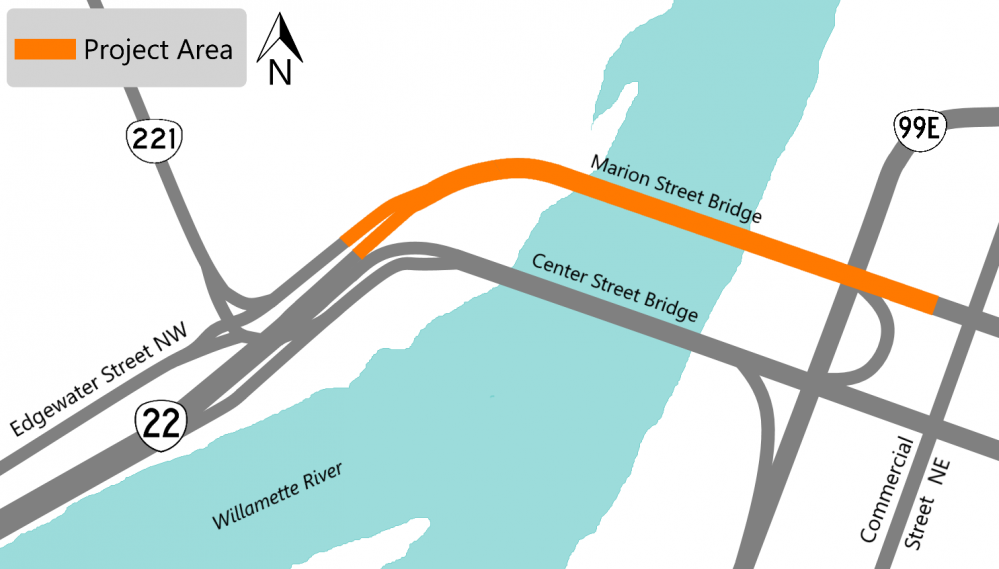
Impacts
Construction will start in late July and is estimated to be completed in 2022.
Expect construction noise, lane and ramp closures with flaggers helping direct traffic safely through the work zone. We are working nightly, Sunday night through Friday morning, 8 p.m. to 7 a.m.
There are four ramps in the project area that will need to close at different times during the project. When the ramps are closed there will be detour routes in place. Details on the ramps and routes will be sent out prior to the closure or they can be found in the trucking advisory on TripCheck.com.
Stay Connected
You can learn more about the project by visiting the project webpage. If you'd like to receive the most up to date information on this project, sign up to receive email alerts about construction updates for the area!
Mission Street: 17th Street to I-5 North Ramps
About
We are making signal enhancements at seven signalized intersections on Mission Street that are historical high crash locations.
Most of the crashes at these intersections are due to congestion, to improve the flow of traffic we are:
-
Replacing any damaged traffic signal sensors.
-
Installing new traffic controllers.
-
Installing traffic detectors.
-
Adding technology that works with current traffic conditions and signals to keep traffic moving smoothly. This technology will adjust when a green light starts and ends to follow the current traffic pattern.
These improvements help manage congestion, as this technology automatically adapts to unexpected changes in traffic conditions and improves travel time reliability.

Impacts
Construction is underway, expect night work with minimal impacts to traffic flow. If lane closures are needed, expect flaggers helping direct traffic safely through the work zone.
Stay Connected
You can learn more about the project by visiting the project webpage. If you'd like to receive the most up to date information on this project, sign up to receive email alerts about construction updates for the area!
ADA Curb Ramp Improvements in Aurora, Carlton and Hubbard
About
We are committed to providing the best accessibility possible to all people using the transportation system!
One of the ways we are doing this is by bringing curb ramps along our highways to current Americans with Disabilities Act (ADA) accessibility standards.
As part of this effort, we are exploring ways to design and construct these ramps more efficiently.
For this project, we are rebuilding curb ramps in various locations:
-
OR 99E in Aurora.
-
OR 47 in Carlton. View the interactive map to see the locations.
-
OR 99E in Hubbard.
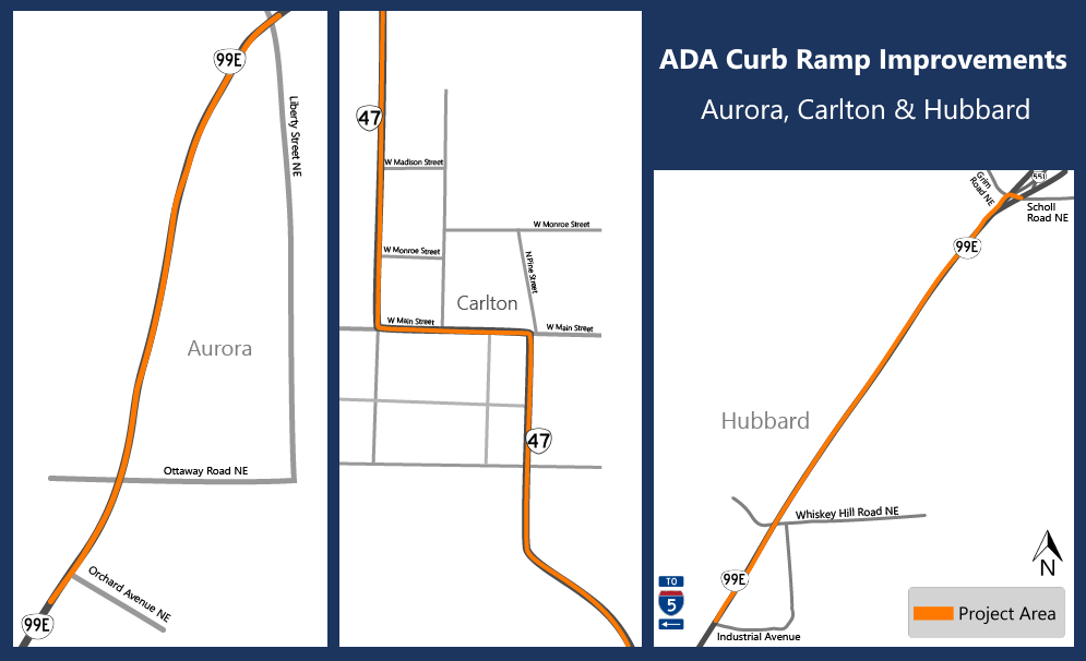
Impacts
Expect construction noise, shoulder and lane closures as needed and travel delays. We expect construction to take place during the day and at night in the different cities. Construction is estimated to be completed in 2022.
-
Aurora: We plan on starting construction this year in early September. We're working on the curb ramps in two batches. We estimate completing the first batch by the end of September. Lane closures will only happen at night.
-
Carlton: Work has started. Construction has paused for the month of August. We plan on returning in October. Crews will be working nights.
-
Hubbard: We anticipate starting work on July 27. We'll be working Monday through Friday from 6 a.m. to 5 p.m.
Tripcheck.com will have the latest traffic and impact information.
Stay Connected
You can learn more about the project by visiting the project webpage. If you'd like to receive the most up to date information on this project, sign up to receive email alerts about construction updates for the area!
OR 219 Pedestrian Safety Project
About
We are making improvements on OR 219 in the City of Newberg to make the area safer for pedestrians.
We are:
-
Constructing sidewalks on the west side of OR 219 by replacing the current drainage ditch with sidewalks.
-
Installing ADA compliant curb ramps.
-
Improving drainage.
-
Striping bike lanes on both sides of the road.
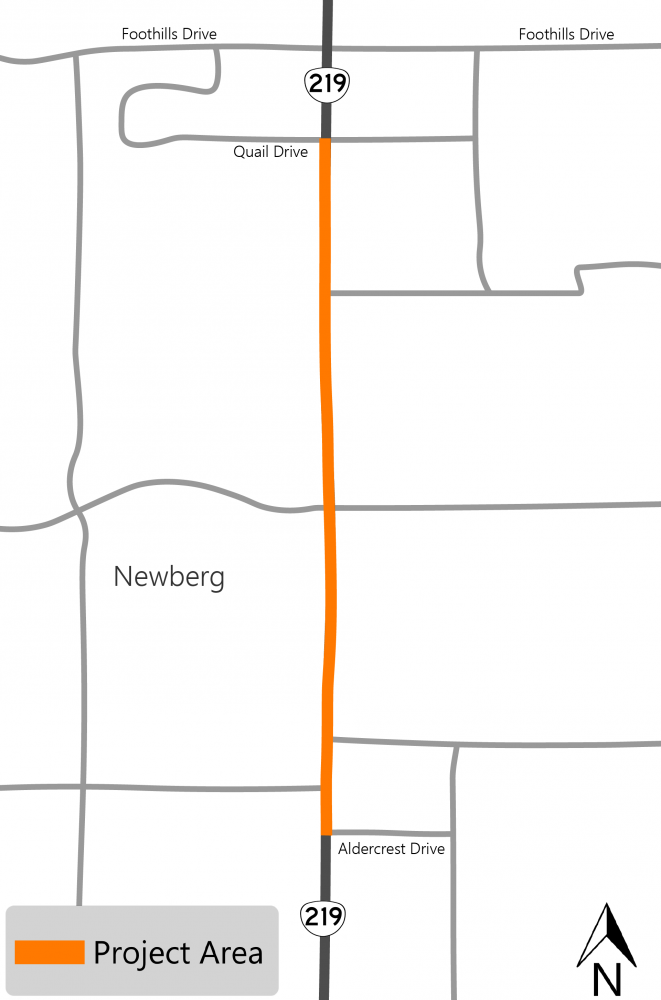
Impacts
Construction will start in 2022. When construction starts, expect delays and occasional shoulder or lane closures with flaggers helping direct traffic.
Stay Connected
You can learn more about the project by visiting the project webpage. If you'd like to receive the most up to date information on this project, sign up to receive email alerts about construction updates for the area!
OR 18 Pedestrian Crossing Enhancements
About
To make the OR 18 and Grand Ronde Road intersection safer for pedestrians, we are:
-
Installing flashing beacons.
-
Upgrading ADA ramps.
-
Improving intersection and crossing illumination.
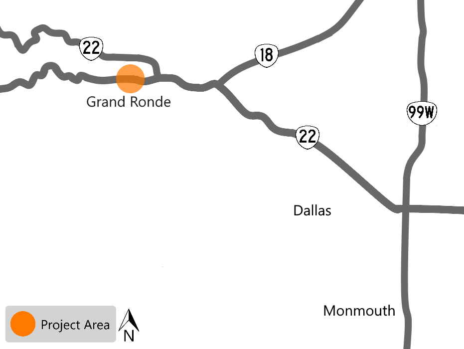
Impacts
Construction activities have begun, expect delays and occasional shoulder and lane closures with flaggers helping direct traffic.
Stay Connected
You can learn more about the project by visiting the project webpage. If you'd like to receive the most up to date information on this project, sign up to receive email alerts about construction updates for the area!
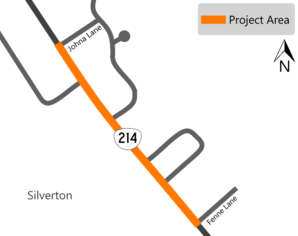
OR 214 Johna Lane to Fenne Lane Sidewalk
About
OR 214, South Water Street, between Johna Lane and Fenne Lane lacks sidewalks and does not meet ADA requirements.
We are constructing a sidewalk on the northeast side of the road, built to ADA standards to make it safer for pedestrians to get from downtown Silverton to the southern neighborhoods.
Impacts
Expect construction noise, delays and occasional lane closures with flaggers helping direct traffic. We are working Monday through Thursday 9:00 a.m. to 4:00 p.m. and on Friday between 9 a.m. to 3 p.m.
Stay Connected
You can learn more about the project by visiting the project webpage. If you'd like to receive the most up to date information on this project, sign up to receive email alerts for the north coast and Willamette Valley! When construction starts, visit TripCheck.com for real time information on traffic and impacts.
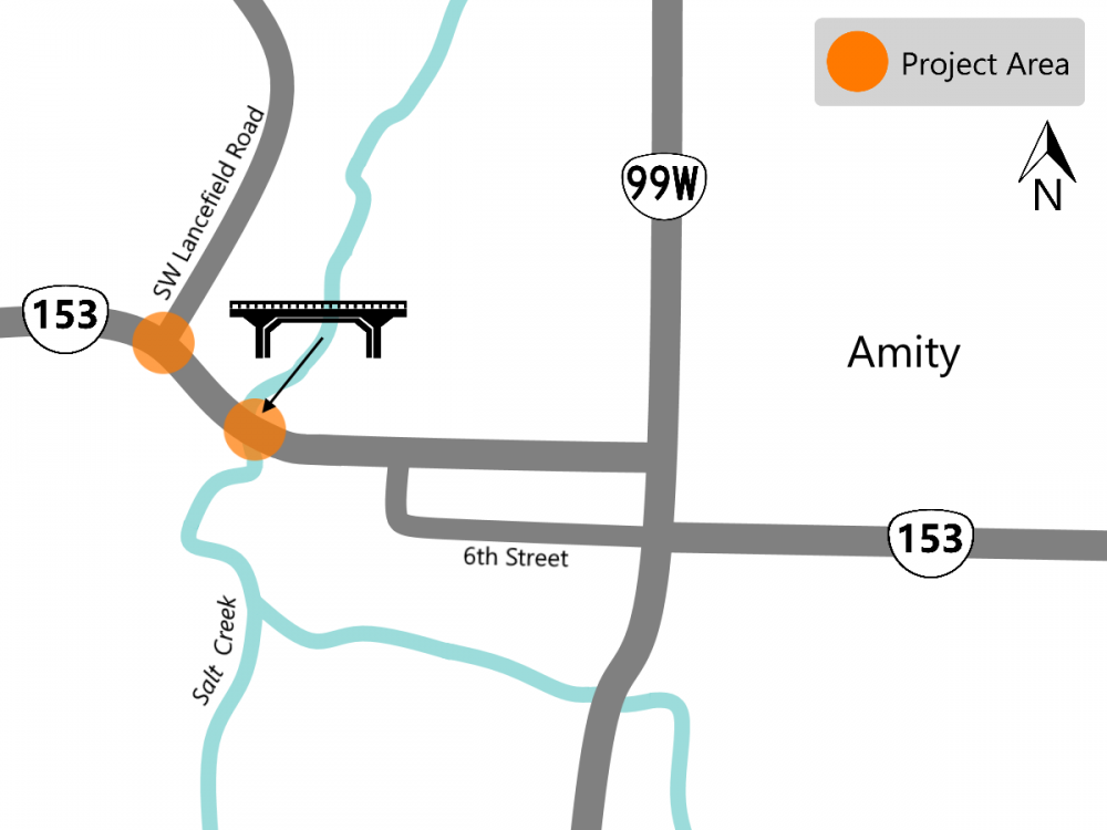
OR 153 Salt Creek Bridge
About
The Salt Creek Bridge was constructed in 1951 to last 50 years. Through regular maintenance and repairs we have been able to extend the life of the bridge, but the wooden structure has deteriorated and rotted to the point where we need to replace it. As part of this project, we are also improving the intersection at SW Lancefield Road to make it easier for drivers to see traffic on OR 153.
Impacts
Construction is underway, expect construction noise. OR 153 is closed while we are replacing the bridge. Construction is estimated to be done in September 2023. There is a detour route in place.
Stay Connected
You can learn more about the project by visiting the project webpage. If you'd like to receive the most up to date information on this project, sign up to receive email alerts about construction updates for the area!
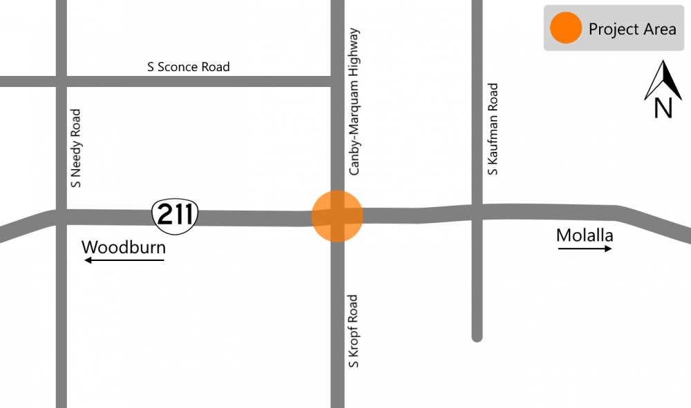
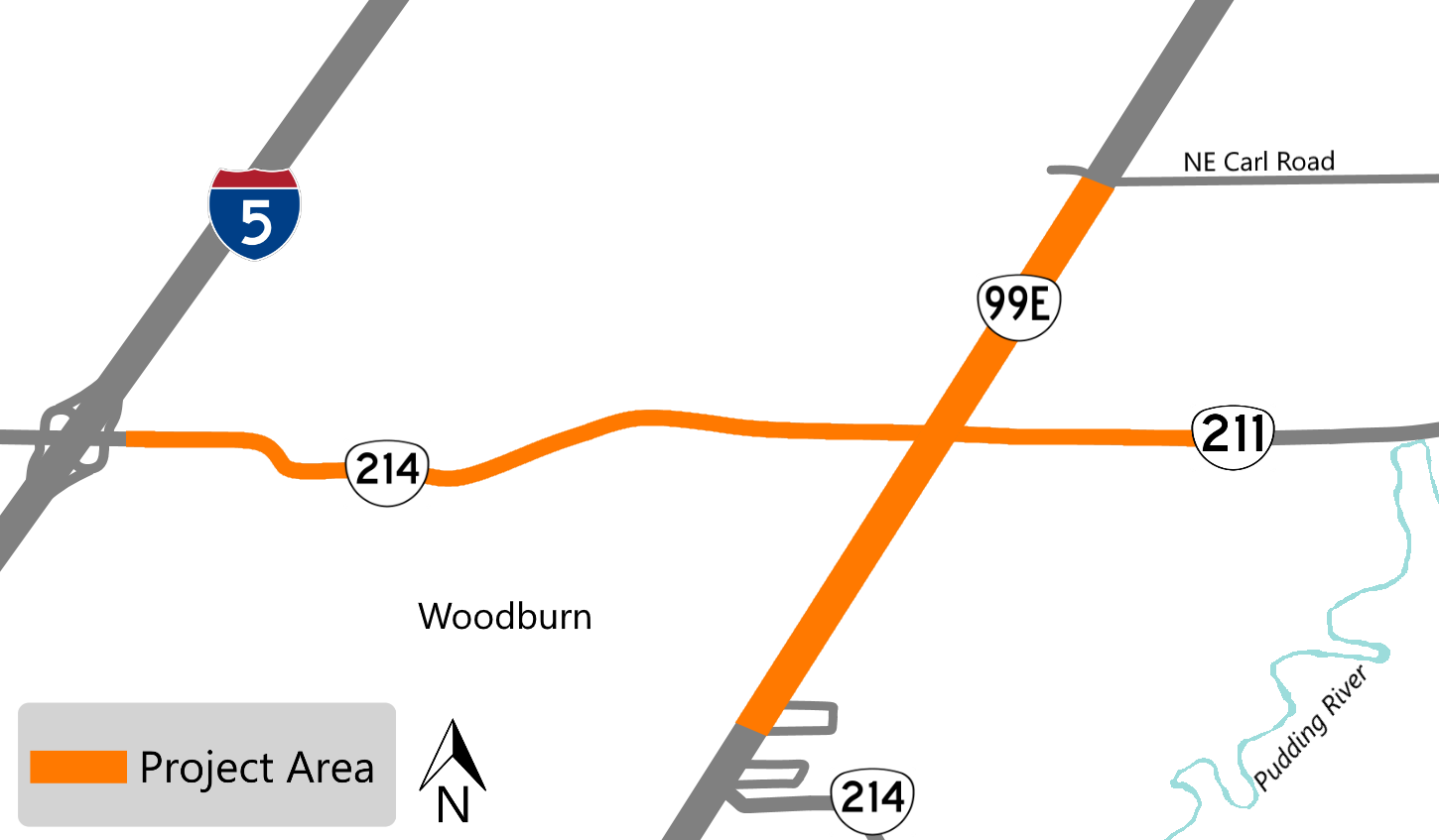
OR 211 Safety Improvements
About
We are making improvements to this intersection to help reduce the number and severity of crashes.
We are:
-
Installing intersection lighting.
-
Enhancing the intersection warning signs and systems.
-
Installing a warning system that will alert drivers on OR 211 that there are vehicles ahead in the intersection.
-
Paving portions of the intersection and reinstalling transverse rumble strips. Rumble strips are grooves cut into the pavement that extend across the entire lane of traffic. When driven over, there is a sound and vibrations that help alert the driver that they are leaving their lane of traffic.
Impacts
Construction is underway and is expected to be done in October 2022. Expect delays and occasional lane closures with flaggers helping direct traffic.
Stay Connected
You can learn more about the project by visiting the project webpage. If you'd like to receive the most up to date information on this project, sign up to receive email alerts about construction updates for the area!
I-5 Aurora Donald Interchange Phase 1A
About
We are completing construction for Phase 1 in two stages. We are constructing Phase 1A in 2022.
In Phase 1A we are:
-
Lengthen and widen the northbound off-ramp.
-
Build a sound wall along the northbound off-ramp.
-
Realign Bents Road to align with Bents Court at Ehlen Road.
-
Install a new traffic signal at the new Bents Road and Ehlen Road intersection.
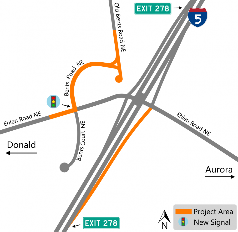
In future phases we will:
-
Replace the I-5 bridges over Ehlen Road.
-
Reconstruct the I-5 travel lanes to match the new I-5 bridge.
-
Construct a four-lane cross section on Ehlen Road, between the northbound and southbound I-5 ramps, with two new left-turn lanes to access the I-5 on-ramps and one through lane in each direction.
-
Lengthen and widen the southbound off-ramp, the southbound on-ramp and the northbound on-ramp – completely upgrading all freeway ramps.
-
Relocate the Dolores Way and Ehlen Road intersection to the east.
Impacts
Expect construction noise, delays and occasional lane closures with flaggers helping direct traffic. We are closing the northbound off-ramp for two weeks in August. While the off-ramp is closed you can use the detour route.
Stay Connected
You can learn more about the project by visiting the project webpage. If you'd like to receive the most up to date information on this project, sign up to receive email alerts for this project!
ADA Curb Ramps in Woodburn and the Surrounding Area
About
We are upgrading or installing new ADA compliant curb ramps around the Woodburn area. We have an interactive map that shows all the corners that are involved in the project.
Impacts
Expect construction noise, delays and shoulder and lane closures with flaggers helping direct traffic. The ramps will be done in stages, mostly in the daytime. Once we start working on the ramps closer to I-5, we will switch to nighttime work.
Stay Connected
You can learn more about the project by visiting the project webpage. If you'd like to receive the most up to date information on this project, sign up to receive email alerts for this project!
OR 219 Roundabout and Butteville Road Realignment
About
There is development happening on the 108 acre industrial complex on the west side of Woodburn. As part of the project there is a roundabout and other improvements being made on OR 219 to improve safety and traffic flow in the area.
Improvements will include:
-
Widening the southbound I-5 exit ramp.
-
Realigning the Butteville road connection to OR 219.
-
Sidewalk and bike lanes on Butteville Road and connecting to the development site.
-
A new roundabout to improve traffic flowing in and out of the development site.
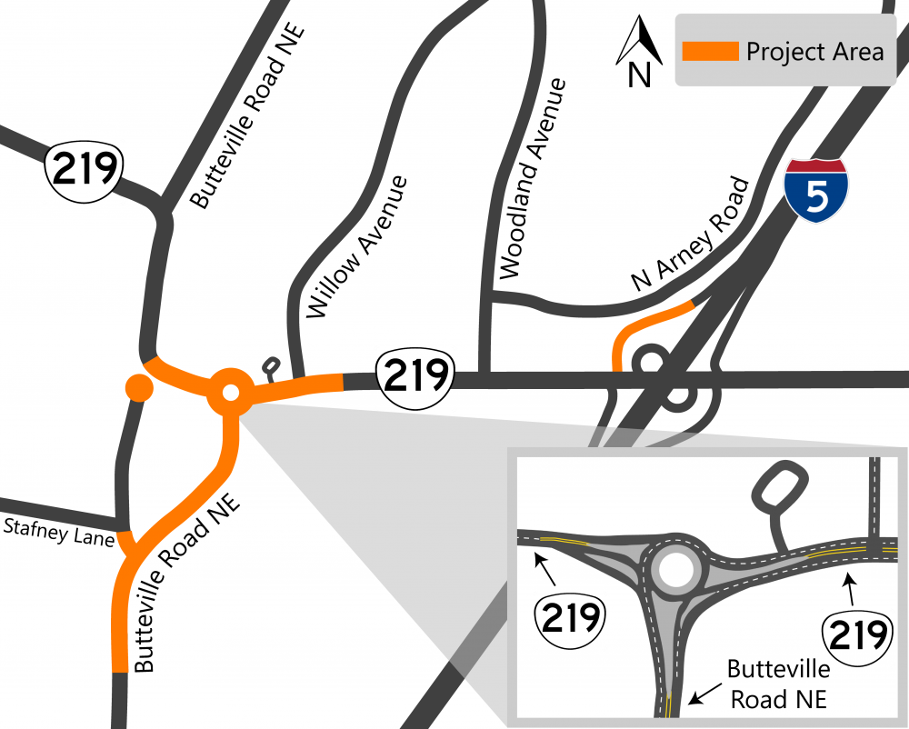
Impacts
Expect construction noise, delays and shoulder and lane closures with flaggers helping direct traffic. Work is mostly being done during the day. The work being done on the I-5 exit ramp will be done at night. The City of Woodburn has a project page with more information on the area development.
The project is being constructed in stages and is estimated to be completed in 2022. At some point to build the roundabout portion, there will be a detour for OR 219 that takes traffic onto the new Butteville Road and then north to reconnect to OR 219.
Stay Connected
If you'd like to receive the most up to date information on projects in the Woodburn area, sign up to receive email alerts! If you have questions, you can contact:
-
Design and project information: Scott Nelson | scott.nelson@odot.oregon.gov | 503-986-2882
-
Construction information: Dennis Pace | dwpa@deainc.com | 541-981-1576
Do you have questions, comment or concerns?
Please let us know by filling out the form below.
![]() To find out what we're working on in 2022, click on the tabs to expand the information!
To find out what we're working on in 2022, click on the tabs to expand the information!
U.S. 20 Landslide Repairs
About
We investigated a landslide location on U.S. 20 east of Sweet Home and along the South Santiam River to find the best solution for the area. We are also conducting further tests at milepost 53.7, but we have no construction planned at this time due to a lack of funding.
In 2021 we are:
-
Starting to install a retaining wall from milepost 56 to milepost 56.2 to help slow the slide movement.
In 2022 we are:
-
Fixing the road surface from milepost 55.4 to milepost 55.6 and milepost 56 to milepost 56.2 to make it more level, creating a smoother ride and preventing water from pooling.
-
Finishing building the retaining wall and changing 1000 feet of road alignment in the slide area between milepost 56 to milepost 56.2.
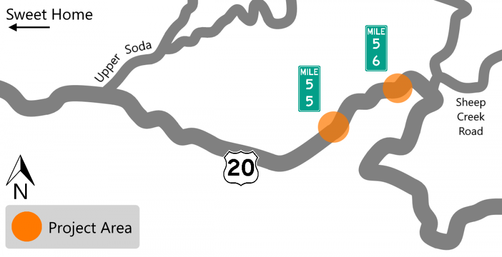
Schedule
We started construction in 2021 and anticipate completing construction by the end of 2022. Plan ahead – there will be a two week full road closure in September 2022, after Labor Day.
Impacts
Expect daytime single lane closures, Monday-Friday, with flagging and short delays.
Plan for:
-
Delays from lane closures.
-
Construction noise.
-
Flaggers helping direct traffic between milepost 55.5 and milepost 56.5.
In September, after Labor Day, we are closing the road for two weeks to pave. We will share the exact dates prior to the closure.
Stay Connected
You can learn more about the project by visiting the project webpage. If you'd like to receive the most up to date information on this project, sign up to receive email alerts about construction updates for the area! Visit TripCheck.com for real time information on traffic and impacts.
U.S. 101 Yaquina Bay Bridge Maintenance and Improvements
About
We are continuing maintenance work on the Yaquina Bay Bridge to help increase the lifespan of the bridge.
We are:
-
Replacing the cathodic protection (corrosion protection) on the bridge.
-
Repairing damaged concrete and making seismic upgrades to retrofit the bridge.

Schedule
We started construction in 2021 and we anticipate completing construction by the end of 2023.
Impacts
Most of the work will be under the bridge and should not impact traffic. Expect sandblasting, spray coating and other general construction noises when work is being done, both in the day and at night. The east sidewalk closed for the duration of the project and expect occasional nighttime single lane closures.
Stay Connected
You can learn more about the project by visiting the project webpage. If you'd like to receive the most up to date information on this project, sign up to receive email alerts about construction updates for the area! Visit TripCheck.com for real time information on traffic and impacts.
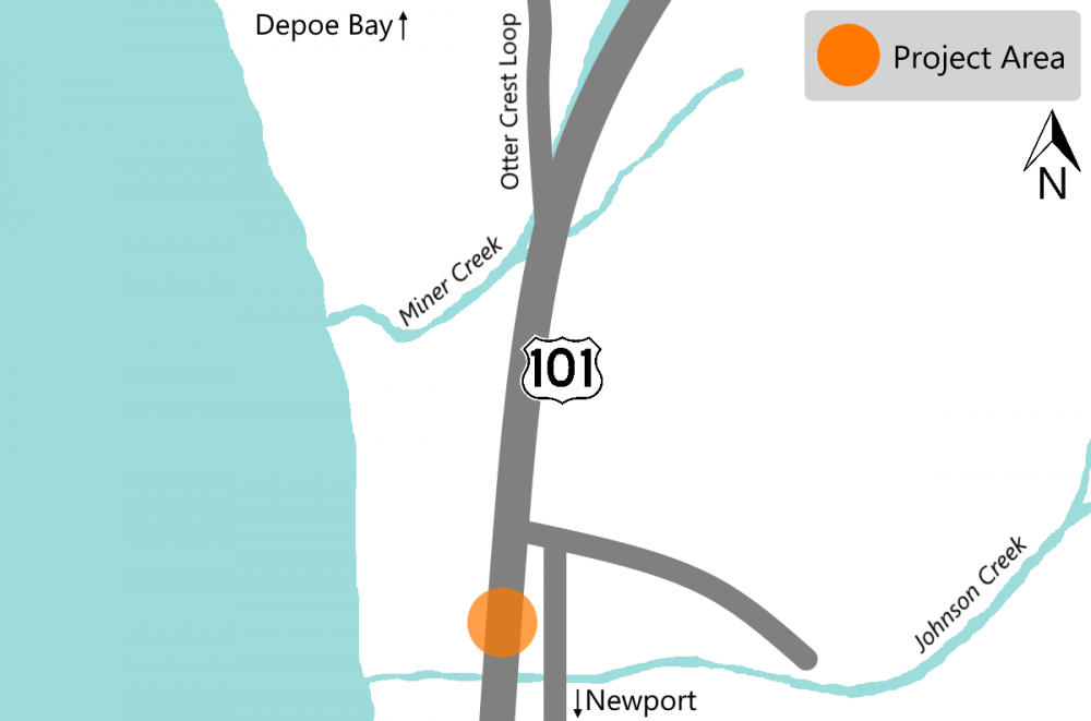
U.S. 101 Johnson Creek Landslide Repair
About
U.S. 101 along the Oregon Coast suffers from significant movement due to local landslides and coastal erosion. With this project, we are installing a trench to improve the drainage in the area. The improved drainage should help slow the slide movement in the area.
Schedule
Construction is underway. Work is being done off U.S. 101, but there will be traffic going in and out of the worksite.
Impacts
The repairs are off of the highway, there should be minimal impacts to traffic flow. Expect up to 20 minute delays when trucks need to enter or exit the job site. There are automated flagger assisted devices installed to keep flaggers safely off the highway.
Stay Connected
You can learn more about the project by visiting the project webpage. If you'd like to receive the most up to date information on this project, sign up to receive email alerts about construction updates for the area! Visit TripCheck.com for real time information on traffic and impacts.
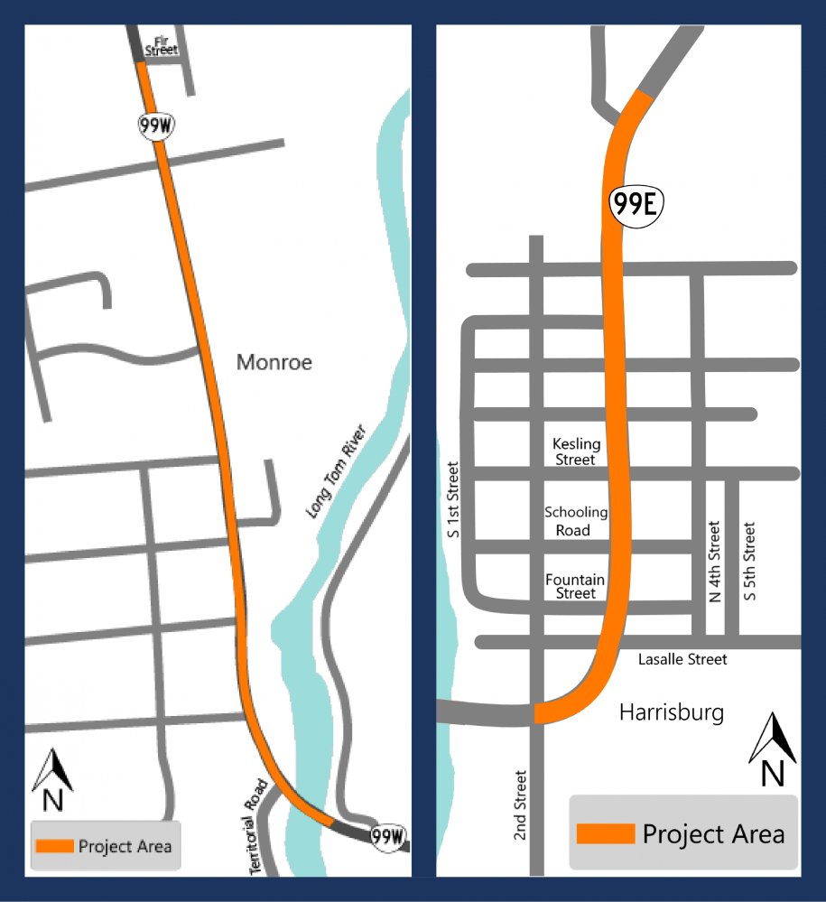
ADA Curb Ramp Improvements (Monroe & Harrisburg)
About
We are committed to providing the best accessibility possible to all people using the transportation system!
One of the ways we are doing this is by bringing curb ramps along our highways to current Americans with Disabilities Act (ADA) accessibility standards.
As part of this effort, we are exploring ways to design and construct these ramps more efficiently.
Impacts
Construction will start late summer 2022. When construction starts, expect construction noise, nighttime shoulder and lane closures and travel delays. Construction staging will change depending on which corners/intersections are being constructed.
In Monroe:
-
We plan on starting construction this year in late September. We're working on the curb ramps in two batches. We estimate completing the first batch by the end of the year.
-
While we are working on Kelly Street and Commercial Street intersection, OR 99 needs to be restricted to one lane of traffic with 24 hour flagging to control the work zone.
-
Construction will occur in 2022 and 2023. Once curbs are completed, the construction area will be repaved. Temporary pedestrian access routes will be available and marked through or around the work zone.
In Harrisburg:
-
We started construction this year on August 15. We're working on the curb ramps in two batches. We estimate completing the first batch by the end of the year.
-
Expect lane shifts, where we move traffic to the center lane off the side of the road where we are working.
-
Expect construction noise and travel delays.
Stay Connected
You can learn more about the project by visiting the project webpage. If you'd like to receive the most up to date information on this project, sign up to receive email alerts about construction updates for the area!
Installing Curve Warning Signs on OR 229 and OR 34
About
Over 50% of Oregon's curve warning and curve advisory speed signs don't meet the current national standards. This is because of outdated technologies used in initial curve analysis, changes in driving habits, improvements in vehicle safety features and inconsistent curve advisory speed changes that have happened over the past several decades. By upgrading and installing new signs, we are creating a safer road system with consistent curve advisory speeds and signs that meet the national standards.
We are:
-
Replacing and adding new signs at locations along OR 34 from milepost 0 to 58.6.
-
Replacing and adding new signs at locations along OR 229 from milepost 0 to 21.2.
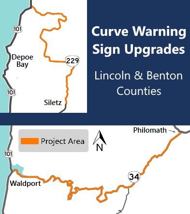
Impacts
Expect shoulder and lane closures with delays up to 20 minutes. The construction zone will change as crews move through the corridors.
Stay Connected
You can learn more about the project by visiting the project webpage. If you'd like to receive the most up to date information on this project, sign up to receive email alerts for the north coast and Willamette Valley!
OR 34 Maltby Creek Timber Deck Replacement
About
We are replacing the timber deck on the OR 34 Maltby Creek Bridge. Work was originally scheduled for 2021.
Unfortunately, the materials we need to be able to do the work didn't arrive on schedule, so the work is delayed until summer 2022.
The bridge continues to be a safe, reliable part of our transportation system.
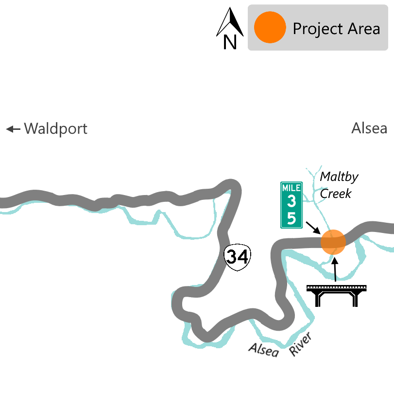
Impacts
DELAYED. We anticipate construction starting in 2023. Expect a full road closure and detour. When the lanes are closed, use U.S. 20 and U.S. 101 to get around the work area. The work is weather dependent and the schedule is subject to change.
Stay Connected
You can learn more about the project by visiting the project webpage. If you'd like to receive the most up to date information on this project, sign up to receive email alerts about construction updates for the area!
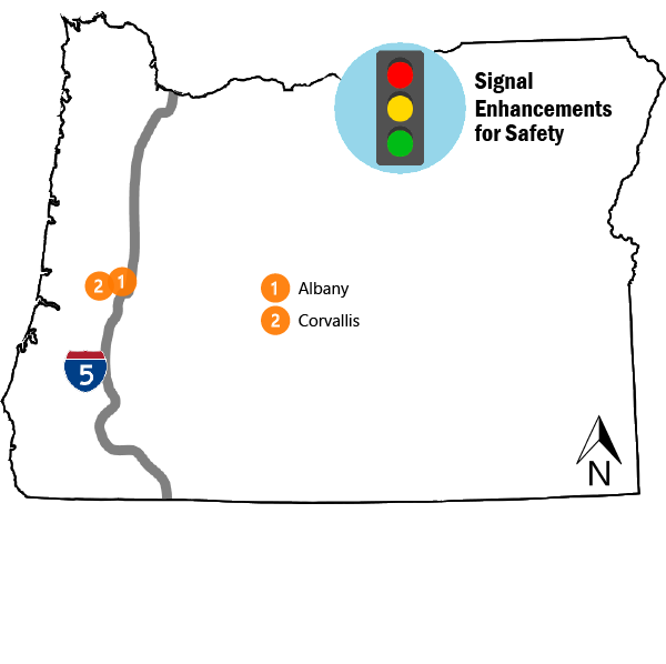
Signal Enhancements in Linn and Benton Counties
About
We are upgrading traffic signal equipment to help reduce fatal and serious intersection crashes. The enhancements vary in each location, but overall we are:
-
Replacing signal heads, as needed.
-
Installing reflective backplates behind the signal heads as needed. The reflective backing helps draw drivers' eyes to the signal and increases their awareness and response.
-
Installing advanced dilemma zone protection as needed. This helps make the intersection safer by adjusting the traffic signal timing to reduce the number of drivers that may have difficulty deciding whether to stop or proceed during a yellow light.
-
Installing video, thermal or radar detection at key intersections. This is a form of non-intrusive detection, as it is not placed within the pavement. This allows for flexibility for where a vehicle or cyclist is detected at the intersection. Where installed, a bicycle can be accurately detected within a travel lane.
-
Installing new or modified lane use signs, as needed, to help drivers navigate which lanes to use when approaching the intersection.
-
Installing new supplemental traffic signal heads. These are installed on the near side of the intersection, at key locations, where visibility of the existing signal heads may be limited. This a redundant signal head that can provide additional feedback to motorists.
-
Installing flashing yellow left turn arrows at key intersections that operate as permissive only (green ball). In a "permissive" mode, a green signal permits vehicles to turn left when an appropriate gap becomes available. In a "protected-permissive" mode, the permissive left turn phase is immediately followed by an exclusive, protected left-turn phase, initiated by a green arrow signal indication.
Impacts
This project is mostly complete. We are currently wrapping up the new bike signal and striping at the intersection of OR 99W and Avery Avenue/Crystal Lake Drive in south Corvallis. Check out our animated bike signal graphic to see how movement will work in once complete.
Please use TripCheck.com for the most up to date traffic information.
Stay Connected
You can learn more about the project by visiting the project webpage. If you'd like to receive the most up to date information on this project, sign up to receive email alerts about construction updates for the area!
OR 99E at Airport Road
About
This area has a higher than normal crash rate, both in frequency and in severity, as identified by the Safety Priority Index System.
To improve this intersection, we are:
-
Realigning Airport Road and installing a left turn lane.
-
Adding curb and sidewalk along Airport Road.
-
Upgrading ADA ramps at the OR 99E and Aiport Road intersection.
-
Replacing and upgrading intersection traffic signals.
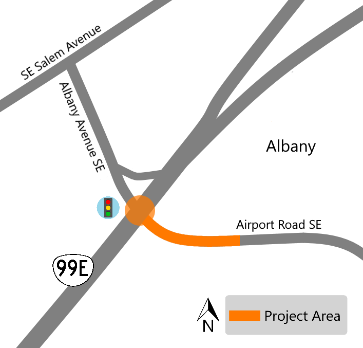
Impacts
Expect construction noise, delays and occasional lane closures with flaggers helping direct traffic. Work will be done nightly Sunday through Thursday from 7 p.m. to 6 a.m.
Stay Connected
You can learn more about the project by visiting the project webpage. If you'd like to receive the most up to date information on this project, sign up to receive email alerts about construction updates for the area!
U.S. 20 Geary Street to Waverly Drive
About
This area has a higher than normal crash rate, both in frequency and in severity, as identified by the Safety Priority Index System.
To address these safety concerns, we are:
-
Making improvements to the intersection of U.S. 20 and Waverly Drive SE.
-
Installing lighting.
-
Replacing the traffic signal.
-
Upgrading curb ramps to current ADA standards.
-
Installing a raised median along U.S. 20 between Waverly Drive SE and SE Clay Street.
-
Installing a new sign structure along OR 99E west of the OR 99E and U.S. 20 intersection.
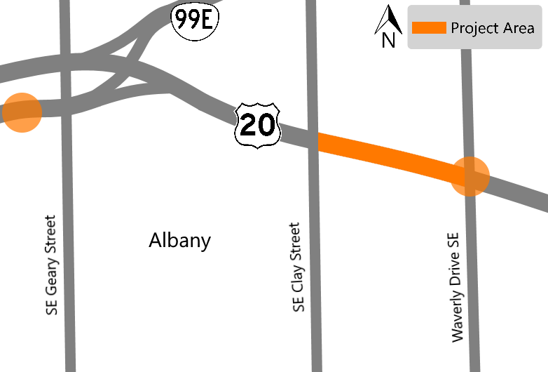
Impacts
Expect construction noise, delays and occasional lane closures with flaggers helping direct traffic. Work will take place at nightly, Sunday through Thursday from 7 p.m. to 6 a.m. We will be installing the new median between Waverly Drive SE and SE Clay Street in late July.
Stay Connected
You can learn more about the project by visiting the project webpage. If you'd like to receive the most up to date information on this project, sign up to receive email alerts about construction updates for the area!
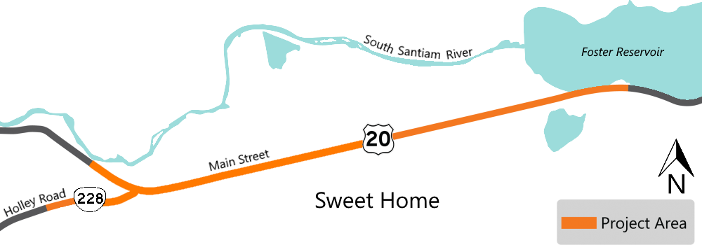
U.S. 20 53rd Avenue to East of 60th Avenue
About
We are improving the pedestrian facility on the east end of the City of Sweet Home, enhancing access for residents and visitors to Foster Lake and to vicinity businesses and employers.
We are:
-
Constructing sidewalks on the north side of U.S. 20 from approximately the 53rd Avenue intersection to east of 60th Avenue.
-
Constructing two mid-block crossings in the vicinities of 40th Avenue at milepost 29 and 49th Avenue at milepost 30. This includes median refuge islands, pedestrian activated rapid flashing beacons, curb ramps and advanced stop striping.
-
Improving the marked school crossing at 54th Avenue with median island refuge and ADA compliant curb ramps and curb extension on the SE corner.
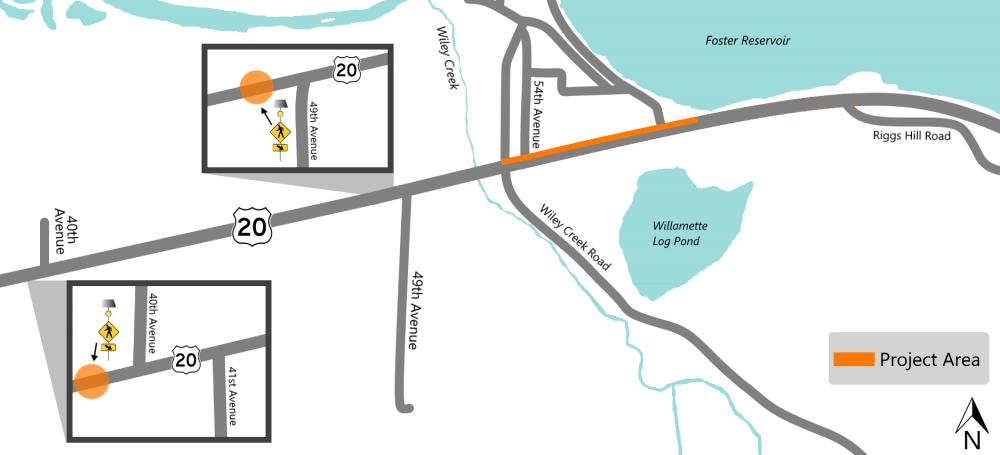
Impacts
Expect construction noise, occasional lane closures and delays with flaggers helping direct traffic. There is a speed reduction through the portions of the work zone that overlaps with the ADA curb ramp project that is also under construction.
Stay Connected
You can learn more about the project by visiting the project webpage. If you'd like to receive the most up to date information on this project, sign up to receive email alerts about construction updates for the area!
ADA Curb Ramp Improvements in Sweet Home
About
We are committed to providing the best accessibility possible to all people using the transportation system!
One of the ways we are doing this is by bringing curb ramps along our highways to current Americans with Disabilities Act (ADA) accessibility standards.
As part of this effort, we are exploring ways to design and construct these ramps more efficiently.
For this project, we are rebuilding curb ramps in various locations:
-
OR 228.
-
U.S. 20.
Impacts
Expect construction noise, shoulder and lane closures with intermittent delays. The speed limit is reduced in the work zone until the project is complete, estimated for April 2023. Our crews are working Monday through Friday, between 7 a.m. to 5 p.m.
Stay Connected
You can learn more about the project by visiting the project webpage. If you'd like to receive the most up to date information on this project, sign up to receive email alerts about construction updates for the area!
U.S. 20 Safety Upgrades
About
U.S. 20 is a rural two lane highway with heavy commuter traffic between North Albany and Corvallis. This section has poor visibility for travelers turning on and off U.S. 20 and a high volume of crashes.
This project implements some of the recommended safety improvements outlined in the 2016 U.S. 20 Highway Safety Study.
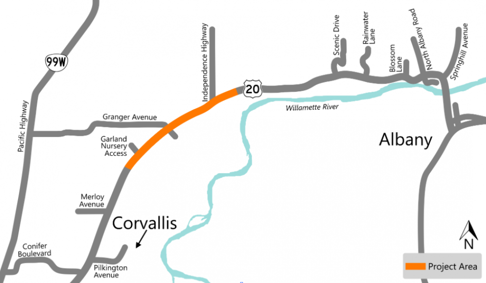
For Phase 1 of this project, we are:
On U.S. 20 at Granger Avenue and Independence Highway
-
Installing a buffered westbound right turn lane.
-
Installing an eastbound median acceleration lane for left turning vehicle
-
Adding striping and signs to help guide bicyclists through the intersections.
-
Upgrading signs and striping at railroad crossings.
-
Installing stormwater treatment facilities.
-
Building a short section of a multiuse path above a new 20+ foot high retaining wall at Independence Highway, to work with the planned Benton County Bikeway.
On U.S. 20 near the Garland Nursery access
-
Widening the shoulders.
-
Adding rumble strips. Rumble strips are grooves cut into the pavement that create sound and vibration when they have driven over, to alert the driver that they are leaving the lane.
-
Raising the outside edge of pavement on the curve.
-
Removing fixed objects, like trees or poles, near the outside of the curve/north side of the highway as possible.
Impacts
We started construction on the east end of the project area near the intersection with Independence Highway and will work our way west. Watch for trucks leaving and entering the roadway. Expect construction noise, occasional nighttime lane closures and delays with flaggers helping direct traffic.
Phase 1 construction is estimated to be completed by August 2023.
Stay Connected
You can learn more about the project by visiting the project webpage. If you'd like to receive the most up to date information on this project, sign up to receive email alerts about this project!
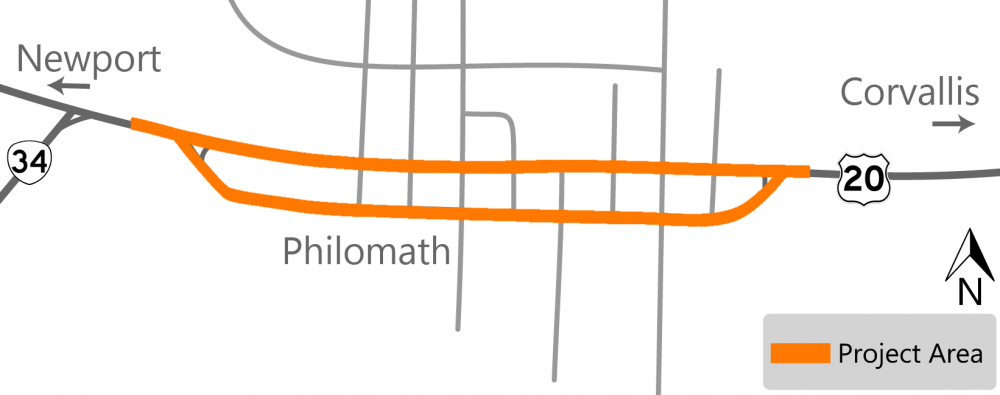
U.S. 20 Philomath Downtown Safety and Streetscape
About
U.S. 20 through Philomath is in poor condition and the sidewalks do not meet current ADA standards. To address this, we will:
-
Fully reconstruct most travel lanes on Main and Applegate within the project area between 14th and 7th Streets. This will involve digging up and rebuilding the foundation of the road. We will repave the surface of the road on the portions not being rebuilt.
-
Regrade the new pavement and the slope of the road to improve drainage.
-
Repave some of the parking areas on Applegate Street and portions of parking on Main Street where full depth reconstruction is not occurring.
-
Curb ramps will be upgraded to comply with ADA standards.
-
Curb extensions will be added on the north and south sides of Main Street and on the north side of Applegate Street within the project area.
-
Install enhanced pedestrian crossings with rectangular rapid flashing beacons (RRFB) on Applegate Street at 14th Street and on Main Street at 7th Street.
-
Buffers will be added between vehicle and bicycle lanes to improve bicycle safety. Striped buffers will be two feet wide on Main Street and four feet on Applegate Street.
-
A two way cycle track will be added on the south side of Applegate between 13th and 15th Streets to provide westbound bicycle access between the Applegate neighborhood and the downtown area and to provide connectivity for the “Corvallis to the Coast” bike route.
-
Mountable concrete curb separators will be added in the four foot buffer along the cycle track to further protect bicyclists.
Impacts
Construction will start in late 2022 and we anticipate completing the work in 2024. When construction starts, expect delays and single lane closures with flaggers helping direct traffic. The plan is to close one lane at a time so that there is always one lane of traffic in each direction available. (Applegate and Main Street)
We will work with property owners and businesses to maintain access during construction.
Stay Connected
You can learn more about the project by visiting the project webpage. If you'd like to receive the most up to date information on this project, sign up to receive email alerts about construction updates for the area!
OR 99E Halsey
About
We are making improvements to OR 99E in downtown Halsey to repair or rebuild the roadway for smoother ride quality. We are also improving stormwater drainage and making upgrades for safer walking and biking. These changes will result in a safer, smoother and more accessible roadway for people who walk, ride bicycles and drive.
Click through the layers on the map to learn more about the improvements coming to OR 99E and where the roadway will be impacted. Improvements include:
Impacts
Expect short term single lane, sidewalk and shoulder closures and lane shifts within the project area. We will work with property owners to coordinate access and driveway closures. Flaggers will direct traffic and detours will be posted. Detours and access for pedestrians, including those with disabilities, will be available and identified through or around work zones.
Daytime work will start in early August on the stormwater system. In the meantime, private utility companies will be relocating their lines.
The work will occur in stages:
- - Water quality shoulder work, full sidewalk reconstruction and surface road construction, working on the east side of OR 99E, north of American Drive to F Street.
- - Water quality shoulder work, full sidewalk reconstruction and surface road construction, working on the west side of OR 99E, north of American Drive to F Street.
- - Full sidewalk and roadway reconstruction, switching traffic from one side to the other of OR 99E, F Street to J Street.
- - Full sidewalk and roadway reconstruction, switching traffic from one side to the other of OR 99E, J Street to milepost 20.22 (end of project).


Stay Connected
You can learn more about the project by visiting the project webpage. If you'd like to receive the most up to date information on this project, sign up to receive email alerts about news and updates for the Halsey area! When construction starts, visit TripCheck.com for real time information on traffic and impacts.
Do you have questions, comment or concerns?
Please let us know by filling out the form below.
![]() To find out what we're working on in 2022, click on the tabs to expand the information!
To find out what we're working on in 2022, click on the tabs to expand the information!
ADA Curb Ramp Improvements in Veneta
About
We are committed to providing the best accessibility possible to all people using the transportation system!
One of the ways we are doing this is by bringing curb ramps along our highways to current Americans with Disabilities Act (ADA) accessibility standards.
As part of this effort, we are exploring ways to design and construct these ramps more efficiently.
Impacts
Construction is underway. We're working nights; expect noise, delays from shoulder and lane closures and for traffic to shift lanes as needed. Work zone may be controlled by flaggers. Temporary pedestrian access routes will be available and marked through or around the work zone.
Stay Connected
You can learn more about the project by visiting the project webpage. If you'd like to receive the most up to date information on this project, sign up to receive email alerts about construction updates for the area!
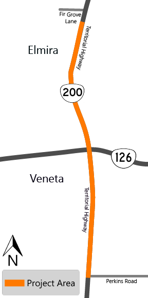
Installing Curve Warning Signs on OR 126, OR 200 and OR 36
About
Over 50% of Oregon's curve warning and curve advisory speed signs don't meet the current national standards. This is because of outdated technologies used in initial curve analysis, changes in driving habits, improvements in vehicle safety features and inconsistent curve advisory speed changes that have happened over the past several decades. By upgrading and installing new signs, we are creating a safer road system with consistent curve advisory speeds and signs that meet the national standards.
We are:
-
Replacing and adding new signs at locations along OR 126 from milepost 14.4 to 41.1.
-
Replacing and adding new signs at locations along OR 200, Territorial Highway, from milepost .6 to 42.1.
-
Replacing and adding new signs at locations along OR 36 from milepost 0 to 51.6.
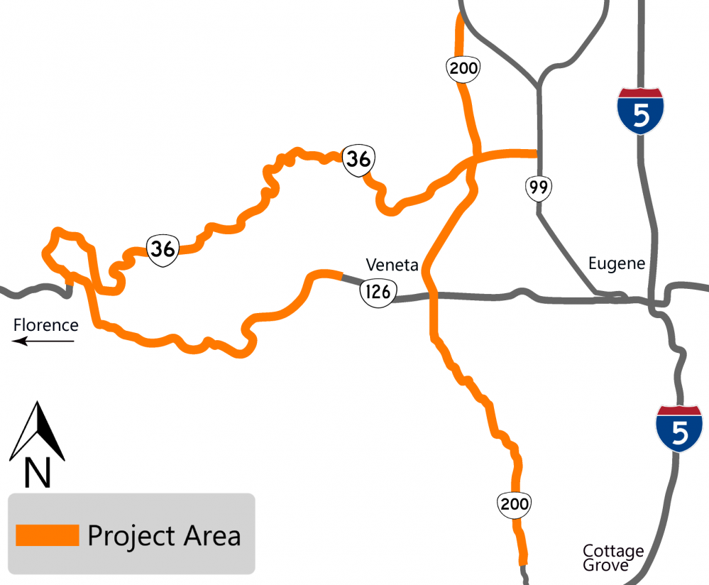
Impacts
Construction is underway, expect shoulder and lane closures and delays up to 20 minutes.
Stay Connected
You can learn more about the project by visiting the project webpage. If you'd like to receive the most up to date information on this project, sign up to receive email alerts for the north coast and Willamette Valley!
OR 569 Green Hill Road to Coburg Road
About
We have done several previous Beltline Highway construction projects in the recent past. This project completes many elements that were not able to be completed with the prior projects.
We are:
-
Adding a new bus pullout at Green Hill Road.
-
Repaving and repairing the highway surface.
-
Replacing signs to meet the current standards.
-
Modifying traffic signals at various intersections.
-
Making ADA improvements to meet the current standards.
-
Making bridge repairs.
-
Replacing the concrete median from Roosevelt Boulevard to Coburg Road.
-
Installing cameras, traffic sensors and variable message board signs at various locations.
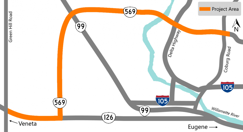
Impacts
Construction to start in August 2022 and we anticipate completing in Fall 2023. When construction starts, we'll start at W 11th Avenue with the ADA curb ramp and utility work, expect noise, delays and occasional lane closures as needed.
Paving activities are weather dependent and may need to wait until 2023.
Stay Connected
You can learn more about the project by visiting the project webpage. If you'd like to receive the most up to date information on this project, sign up to receive email alerts about construction updates for the area!
OR 569 Bridge Repair and Safety Improvements
About
The bridge is located on the Beltline highway, where the highway crosses over the UPRR railroads and NW Expressway in Eugene. The bridge needs repairs to keep it in good working condition for years to come.
We are:
-
Replacing the bridge railing, which is outdated and needs to be brought up to current standards.
-
Replacing any joints that are leaking or damaged.
-
Installing a concrete overlay to replace the driving surface (bridge deck) and give road users a smoother ride.

Impacts
We anticipate construction starting in August. When construction starts, expect lane and ramp closures, delays and construction noise.
Stay Connected
You can learn more about the project by visiting the project webpage. If you'd like to receive the most up to date information on this project, sign up to receive email alerts about construction updates for the area!
OR 99 Front Street Safety Improvements
About
The railroad crossing in this area of Creswell is damaged needs to be replaced to make it safer for all users. CORP Railroad is replacing the siding and mainline tracks across the highway with concrete panels to provide a smoother crossing for vehicles.
We are:
-
Improving the pedestrian crossing on the south to provide a wider and level pedestrian path.
-
Installing truncated domes on either side of the tracks and one sidewalk curb ramp will be improved. Truncated domes are usually textured yellow metal plates installed on the ground that can be seen, felt and heard to increase safety.
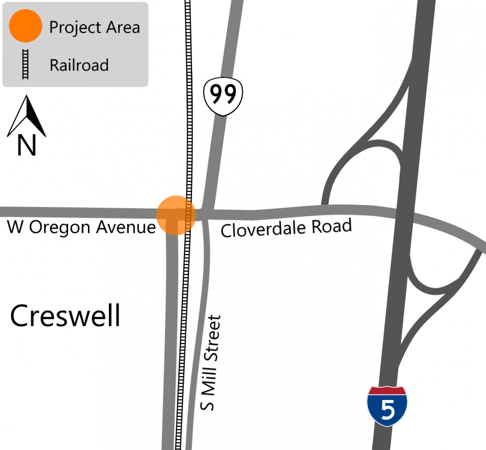
Impacts
We anticipate construction starting in September. When construction starts, expect delays and construction noise. To complete the railroad work, the road will need to close for four to five days. During the full road closure, detour and alternate routes will be marked.
Stay Connected
You can learn more about the project by visiting the project webpage. If you'd like to receive the most up to date information on this project, sign up to receive email alerts about construction updates for the area!
OR 99W Junction City Paving
About
We are repaving OR 99 between 1st Avenue, milepost 109.63, and Enid Road, milepost 116.74, from Junction City to Eugene. The current pavement is deteriorating, we are replacing the surface layer to extend the roads useful life and provide travelers with a smoother ride and address safety concerns.
We are:
-
Paving the highway between milepost 109.65 and 116.70.
-
Installing centerline rumble strips.
-
Installing waterproof membranes on three bridges.
-
Upgrading curb ramps to meet Americans with Disabilities Act (ADA) requirements.
-
Upgrading pedestrian signals as necessary.
-
Replacing Junction City's weigh in motion system, used to capture truck traffic data without affecting traffic flow.
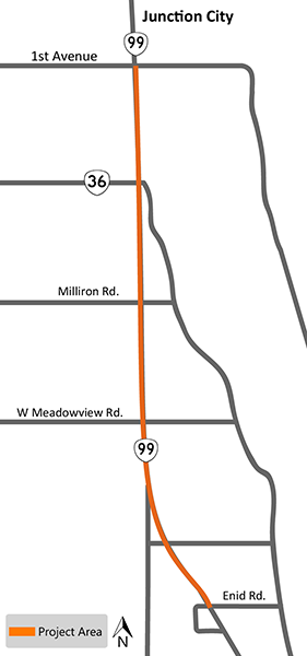
Impacts
We anticipate construction starting in late July. When construction starts, expect road closures, lane closures and detours, but every effort will be made to minimize impacts to travelers.
 To help expedite construction and minimize the duration of impacts, we are planning to have weekend lane shifts, or crossovers, where we move traffic off the side of the road where we are working. You can click on the diagram to enlarge and see how the lane shift will work. At this time the crossovers are planned for several weekends from 7 p.m. on Friday through 6 a.m. Monday. The current schedule is:
-
July 29 - August 1
-
August 5 - August 8
-
August 19 - August 22
-
August 26 - August 29
Stay Connected
You can learn more about the project by visiting the project webpage. If you'd like to receive the most up to date information on this project, sign up to receive email alerts about construction updates for the area!
ADA Curb Ramp Improvements in Junction City
About
We are committed to providing the best accessibility possible to all people using the transportation system!
One of the ways we are doing this is by bringing curb ramps along our highways to current Americans with Disabilities Act (ADA) accessibility standards.
As part of this effort, we are exploring ways to design and construct these ramps more efficiently.
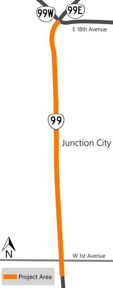
Impacts
We plan on starting construction this year in early October. We're working on the curb ramps in two batches. We estimate completing the first batch by the end of the year. When construction starts, expect travel delays.
One lane of OR 99 needs to be closed for the duration of the project with traffic shifted depending on which curb corners are being constructed.
Single lane closures will occur in the fall/winter months of 2022 and 2023. Temporary pedestrian access routes will be available and marked through or around the work zone.
Stay Connected
You can learn more about the project by visiting the project webpage. If you'd like to receive the most up to date information on this project, sign up to receive email alerts about construction updates for the area!
OR 99 Urban Upgrades
About
The stretch of OR 99 through Cottage Grove connects homes to shopping and services. The road is in need of repair and improved pedestrian and bicycle facilities.
We are:
-
Changing the roadway to one lane in each direction with a center turn lane.
-
Building new sidewalks and bike lanes to current ADA standards.
-
Installing a crosswalk with a rapid flashing beacon.
-
Replacing the signal at the Woodson Place intersection.
-
Repaving the roadway.
Take a look at our interactive project map to learn more about the improvements we are making in Cottage Grove.
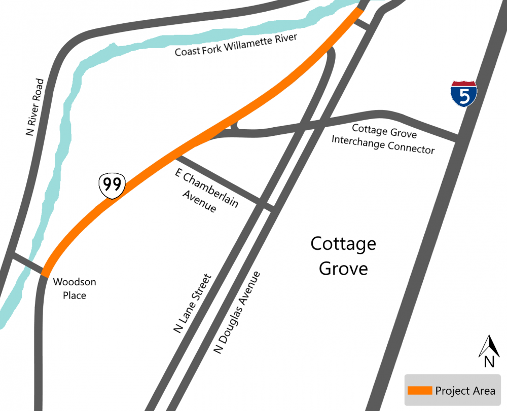
Impacts
We anticipate construction starting in August and completing in 2023. When construction starts, expect delays and occasional lane closures as needed. We are planning to do most work during the daytime, however, there will be times when we work at night to minimize traffic impacts during paving.
Construction will be done stages. The existing four lane road will be reduced to a two lane roadway with 14 feet of travel lanes defined using barrels or cones. When paving the centerline section, there will be a single travel lane in each direction.
Stay Connected
You can learn more about the project by visiting the project webpage. If you'd like to receive the most up to date information on this project, sign up to receive email alerts about construction updates for the area!
OR 58 Paving
About
We are paving from Salt Creek Tunnel to milepost 70. The pavement is in poor condition and we are replacing it to preserve the road structure and provide travelers with a smooth ride.
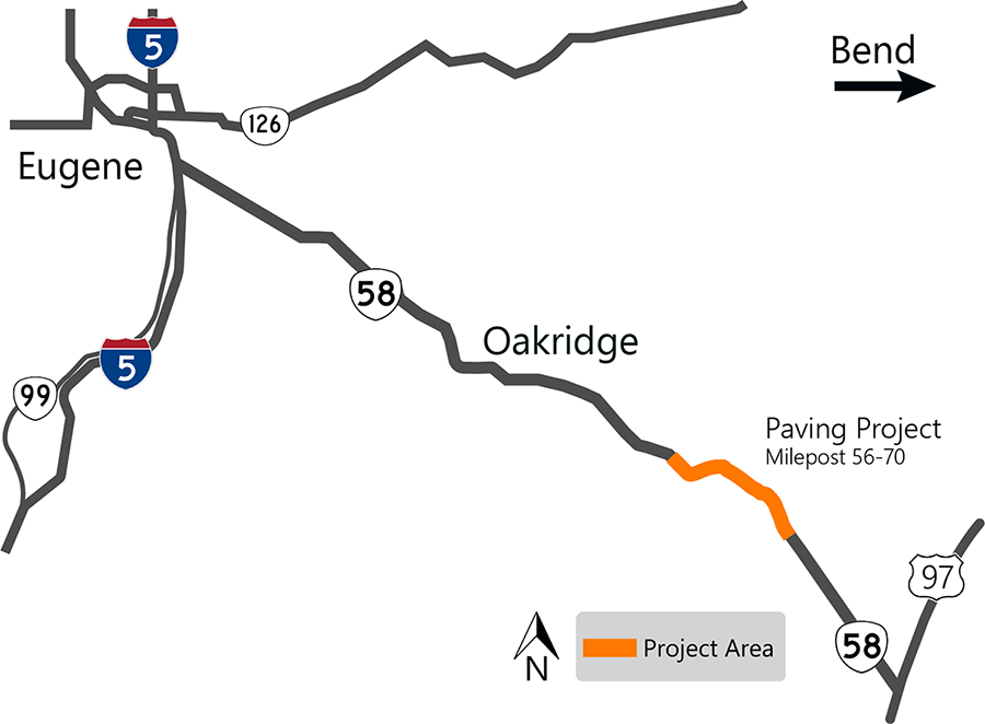
Impacts
We've started installing temporary signs, guardrail and bridge deck work. Paving will start in July. Expect construction noise, nighttime work with lane closures and delays. The work zone and traffic will be controlled using flagging and pilot cars.
We will start on the east end and work towards the tunnel, paving both lanes as we move through the corridor.
Stay Connected
You can learn more about the project by visiting the project webpage. If you'd like to receive the most up to date information on this project, sign up to receive email alerts about construction updates for the area!