In this online open house, you can:
-
See the updated designs for our top two interchange options.
-
Check out our interactive map to see our access road designs options – share your thoughts by leaving a comment on the map.
-
Learn about the multiuse path designs that will improve safety for pedestrian and bicycle users.
-
Find out how you can join us at our in-person open house on July 12.
-
Learn how you can stay connected and share your thoughts in our comment form.
Stations
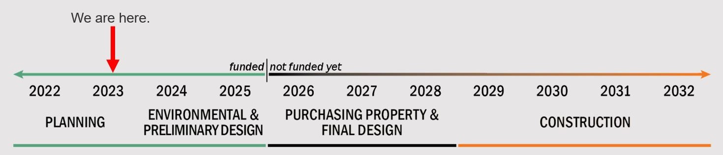
Project Schedule and Funding
We're currently:
- Working with you and your community to improve our designs.
- Carrying out environmental research.
- Completing early design to verify the concepts developed in the OR 22W Expressway Management Plan.
At the end of the funded phase, we'll have a cost estimate and a plan to build the project in stages. We plan to finish this work in 2025.
By building a project of this size in stages, we can have more time to find the required funding for each stage. It also helps reduce impacts to the community during construction.
We don't have funding for future phases. When we get funding, we can:
- Finish a more detailed design.
- Purchase property.
- Work with our partners to relocate utilities as needed.
- Construct the project in stages.
The years shown on the timeline are approximate. The timing will depend on whether funding is available to complete the project.
Click on the "+" or the title below to view the information in each section.
Since the fall of 2022, we've been sharing and updating designs as we've gotten feedback from the community. This includes:
- Meeting with business and property owners to hear their ideas.
- Working with Polk County to improve the project designs.
- Presenting to the City of Independence and the City of Dallas to hear their input.
- Sharing updates with the West Salem Business and Neighborhood Associations.
Based on public input, we’ve been refining the interchange and access road design options. Thank you for your feedback – it's helped us make the project better for your community. We commit to working together to improve safety and mobility in the area for everyone.
We saw a strong community response to our November 2022 online open house with 818 visits. Your feedback helped narrow down the interchange design options.
We heard you – there were a few common themes that emerged from the online open house and virtual meeting:
- Safety: Our goal for the project is to make the area safer for everyone traveling along the corridor. Many of you voiced your support for this project and our goal.
- Private properties and the historic Brunk House: Several people had questions about the access roads and expressed how important the historic Brunk House is to your community.
- Pedestrian and bicyclist safety: We will be upgrading the existing multiuse path to meet modern standards.
- Speed limits: Several people asked for us to lower the speed limit in the area. We’ve considered lowering the speed limit. Drivers already disobey the posted speed limits. Even if we lowered the speed, drivers would likely continue to drive over the posted limit.
View the previous online open house. It includes information about the interchange design options that we considered.
You Voted
The Dogbone Interchange was the top option because it looked simple to use and would help traffic flow. The Northwest Loop Interchange came in second. We've eliminated the Dual Loop Interchange and the Northeast Loop Interchange options.
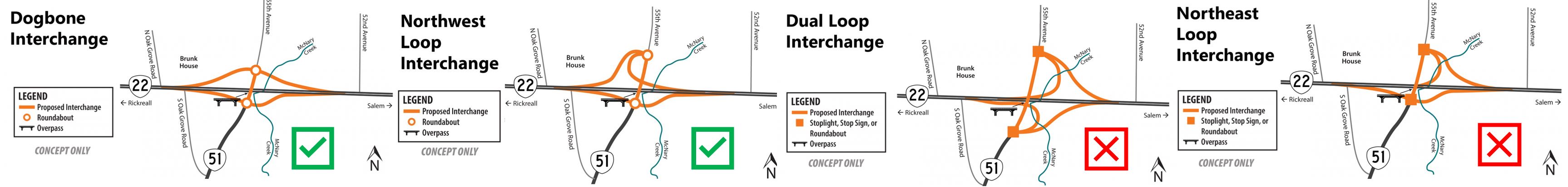
Click on the image to enlarge.
We've Updated the Top Two Designs
Dogbone Interchange
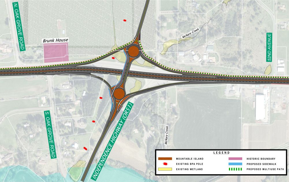
This option is more compact.
It has a lower impact to neighboring properties.
Click on the image to enlarge.
Northwest Loop Interchange
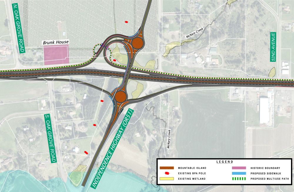
This option has a larger impact to neighboring properties. It includes a dedicated loop ramp for traffic between Salem and Independence.
Click on the image to enlarge.
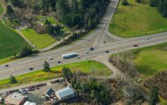
We know how traffic would flow through the two new intersections on OR 51. We considered stop signs, traffic lights or roundabouts. After looking at traffic data and the sites, we found that roundabouts will work best.
We're evaluating which of the two interchange options is best for this project. In the next station, you can see access road options that work with both interchanges.
At our last open house, we showed you a map with several possible access roads we were looking at. Since then, we've eliminated many options by looking at environmental and property impacts.
We value your input and feedback – you can help us with the design by telling us your top access road options.
Click on the "+" or the title below to view the information in each section.
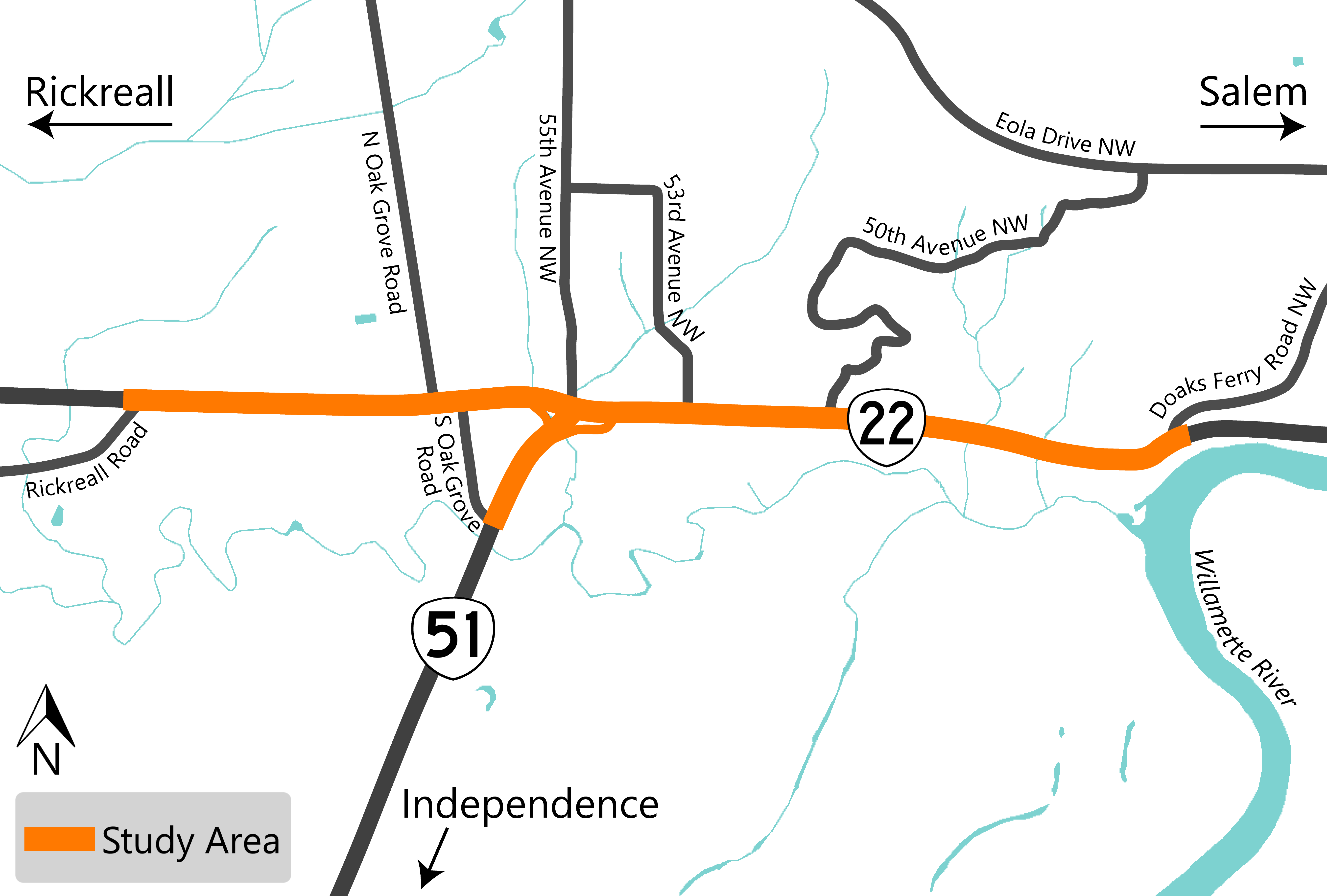
We're Looking at Two Access Road Options North of OR 22
- Option 1 would connect to 55th Avenue using existing roads, 52nd Avenue to Aster Street.
- Option 2 would construct a new road near OR 22 to connect to 55th Avenue just north of the intersection with OR 51.
Learn more about each access road option by clicking on the tabs below.
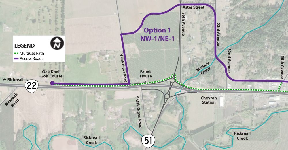
Option 1 (NW-1/NE-1)
To navigate through this option:
- Westbound drivers on Doaks Ferry Road would continue on 52nd Avenue, go north on 53rd Avenue and then continue onto Aster Street. Then they can turn left onto 55th Avenue to reach the OR 22 and OR 51 interchange or continue to get to the Oak Knoll Golf Course.
- Eastbound drivers leaving the Oak Knoll Golf Course would continue up N Oak Grove Road onto a new section of road before reaching 55th Avenue. Then they can turn right onto 55th Avenue to reach the OR 22 and OR 51 interchange or continue forward onto Aster Street.
One advantage of this route is that it would have fewer impacts compared to Option 2.
- Pro: We'd use some existing county roads. This would cause fewer impacts to private property and avoid impacts to McNary Creek.
- Con: But drivers would need to travel a longer distance and along some roads with very steep hills.
Click on the image to enlarge.
Option 2 (NW-2/NE-4)
To navigate through this option:
- Westbound drivers on Doaks Ferry Road would continue past 52nd Avenue onto a new road that hugs OR 22 to a new intersection at 55th Avenue. Then they would turn left onto the realigned 55th Avenue to reach the OR 22 and OR 51 interchange or continue to get to the Oak Knoll Golf Course.
- Eastbound drivers leaving the Oak Knoll Golf Course would continue up N Oak Grove Road onto a new section of road before reaching 55th Avenue. This new intersection would be south of Aster Street. Then they can turn right onto 55th Avenue to reach the OR 22 and OR 51 interchange or continue on the new road.
- Pro: This option would provide the most direct access and the shortest driving distance to businesses.
- Con: But this option would require constructing a new road on empty land. This would mean buying more property from private landowners to establish the access road. Additionally, this option would involve crossing McNary Creek, which would introduce environmental impacts.
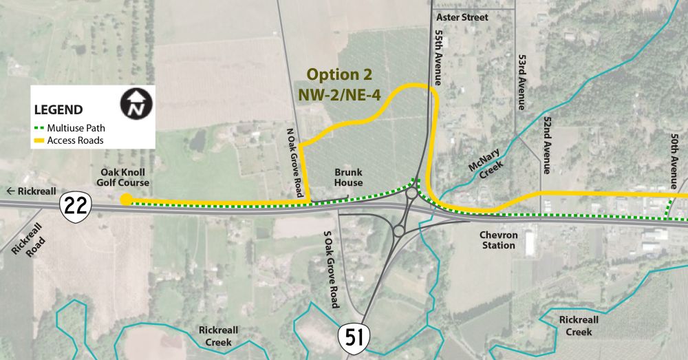
Click on the image to enlarge.
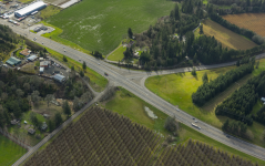
We're Looking at Two Access Road Options South of OR 22
- Option 3 would hug the highway and connect to a new alignment for South Oak Grove Road intersection at OR 51.
- Option 4 would go through an agricultural field and onto the old railroad grade. It would connect to the existing OR 51 and South Oak Grove Road intersection.
Learn more about each access road option by clicking on the tabs below.
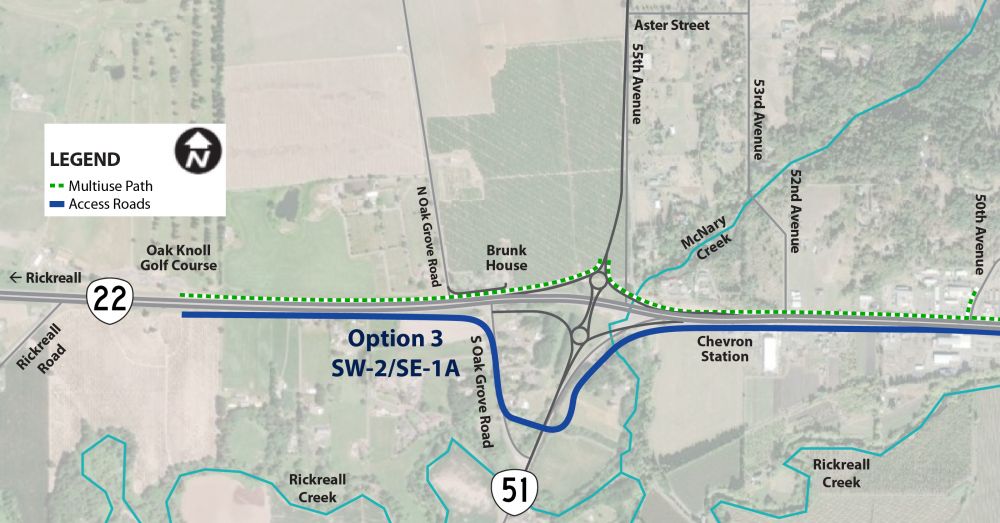
Option 3 (SW-2/SE-1A)
For this option:
- The road continues past the Chevron station hugging the highway and would be located close to where the existing OR 51 to OR 22 merge lane is now. It would then go south and then connect to OR 51.
- The road would realign the South Oak Grove Road connection to OR 51 with the new access road to the east.
- Pro: This option would provide a direct connection to the interchange area. It would allow efficient travel and reduce impacts to the floodplain.
- Con: But, it is important to consider that this option would involve a realignment of South Oak Grove Road. This would result in extra impacts to private property. Additionally, this option involves crossing McNary Creek which introduces environmental impacts.
Click on the image to enlarge.
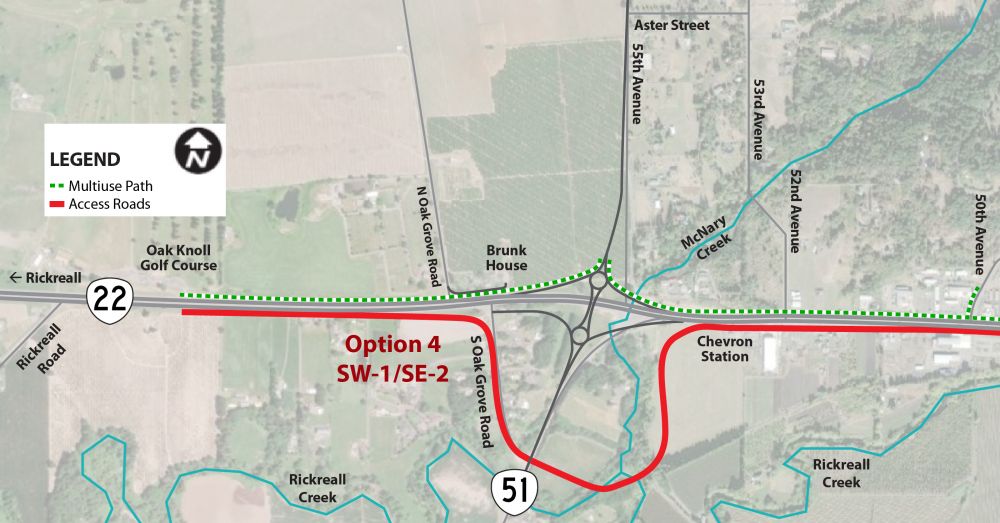
Option 4 (SW-1/SE-2)
- This option goes south after the Chevron Station through an agricultural field onto the old railroad grade. It would then curve up West over Rickreall Creek and then connect to OR 51.
- This option will keep the existing South Oak Grove Road connection to OR 51 which will align with the new access road to the east.
- Pro: This option would result in fewer impacts on private property. It would keep the existing South Oak Grove Road intersection location. It would avoid any negative impacts on McNary Creek.
- Con: However, this option would need a longer driving distance. It would have greater impacts on the floodplain. Additionally, this option involves crossing Rickreall Creek twice, which introduces environmental impacts.
Click on the image to enlarge.
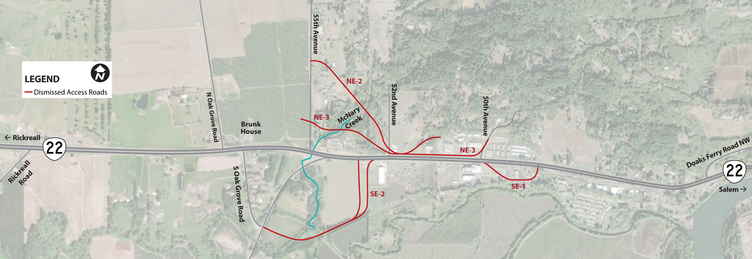
We considered the access road options shown below in red, but dismissed them for several reasons:
- There are steep grades in some areas that would make road design challenging.
- Impacts to too many properties, including businesses, or driveways.
- Cost.
- Negative impacts to natural resources.
Click on the image to enlarge.
Interactive Map
How to use the interactive map:
-
To pan, click and hold on the map using your mouse or finger and drag in the direction you wish to pan.
-
To zoom in and out, use the scroll wheel on your mouse or do a pinching motion with your fingers on your touchscreen. You can also use the zoom buttons at the top left of the window.
-
To customize what information is visible on the map, click the eye icon
 next to the map layers to turn them on or off. Click on the arrow icon
  to expand a dropdown list of additional layers.
How to share a comment on the interactive map:
- On the right-hand side of the map, make sure the eye icon next to "Public Comments" is turned on.
- On the right-hand side of the map, click on the navy blue square with the pencil and notepad icon
 .
. - A box will appear and then, under "Public Comments" select the category that best describes your comment:
- "Issue"
- "Suggested Improvement"
- "Other"
- Click the area on the map to mark the location your comment is about.
- Fill out the fields and click "Create" to post your comment.
If you're unable to leave a comment on the interactive map, don't worry – you can also use this comment form to give us your feedback.
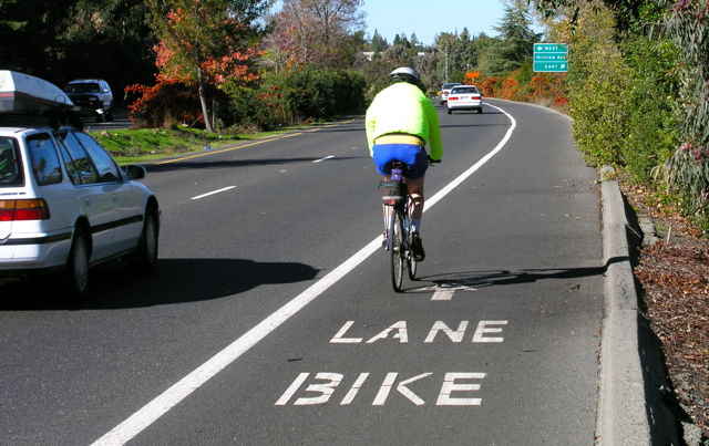
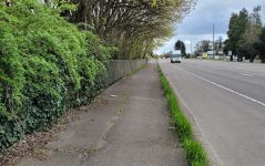
The project will upgrade the existing eight-foot sidewalk on the north side of the highway to a 12 to 14-foot multiuse path. A concrete barrier will separate it from traffic to protect users and enhance safety.
We're proposing sidewalks at:
- The new interchange bridge at OR 51 that crosses over the top of OR 22.
- Sections of the south access road where businesses are.
OR 51, 55th Avenue and both access roads (north and south) will have shoulders for bike traffic.
Multiuse Path with the Dogbone Interchange
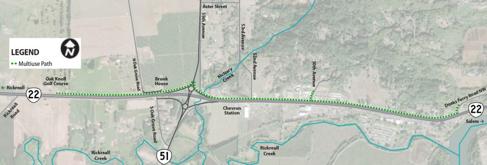
Click on the image to enlarge.
Multiuse Path with the Northwest Loop Interchange
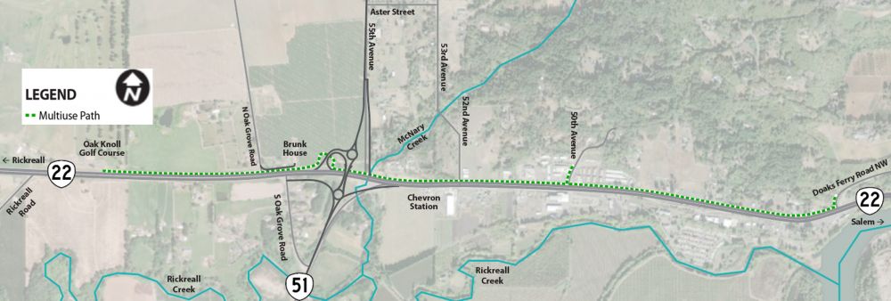
Click on the image to enlarge.
How to use the interactive map:
-
To pan, click and hold on the map using your mouse or finger and drag in the direction you wish to pan.
-
To zoom in and out, use the scroll wheel on your mouse or do a pinching motion with your fingers on your touchscreen. You can also use the zoom buttons at the top left of the window.
-
To customize what information is visible on the map, click the eye icon
next to the map layers to turn them on or off. Click on the arrow icon to expand a dropdown list of additional layers.
How to share a comment on the interactive map:
- On the right-hand side of the map, make sure the eye icon next to "Public Comments" is turned on.
- On the right-hand side of the map, click on the navy blue square with the pencil and notepad icon .
- A box will appear and then, under "Public Comments" select the category that best describes your comment:
- "Issue"
- "Suggested Improvement"
- "Other"
- Click the area on the map to mark the location your comment is about.
- Fill out the fields and click "Create" to post your comment.
If you're unable to leave a comment on the interactive map, don't worry – you can also use this comment form to give us your feedback.

We Want to Hear From You
Please fill out the comment form below or open in a new window to share your thoughts.
Stay Connected
 You can always learn more about the project, find out about upcoming events and stay connected by visiting the project webpage.
 If you have not already, sign up to receive future updates about this project.
Please help us spread the word about this online open house.
Feel free to share this with your friends and neighbors so that we can get their feedback.
Thank you for participating!