Accessibilty and Language Options (Opens in new window.)
Stations

Project Schedule

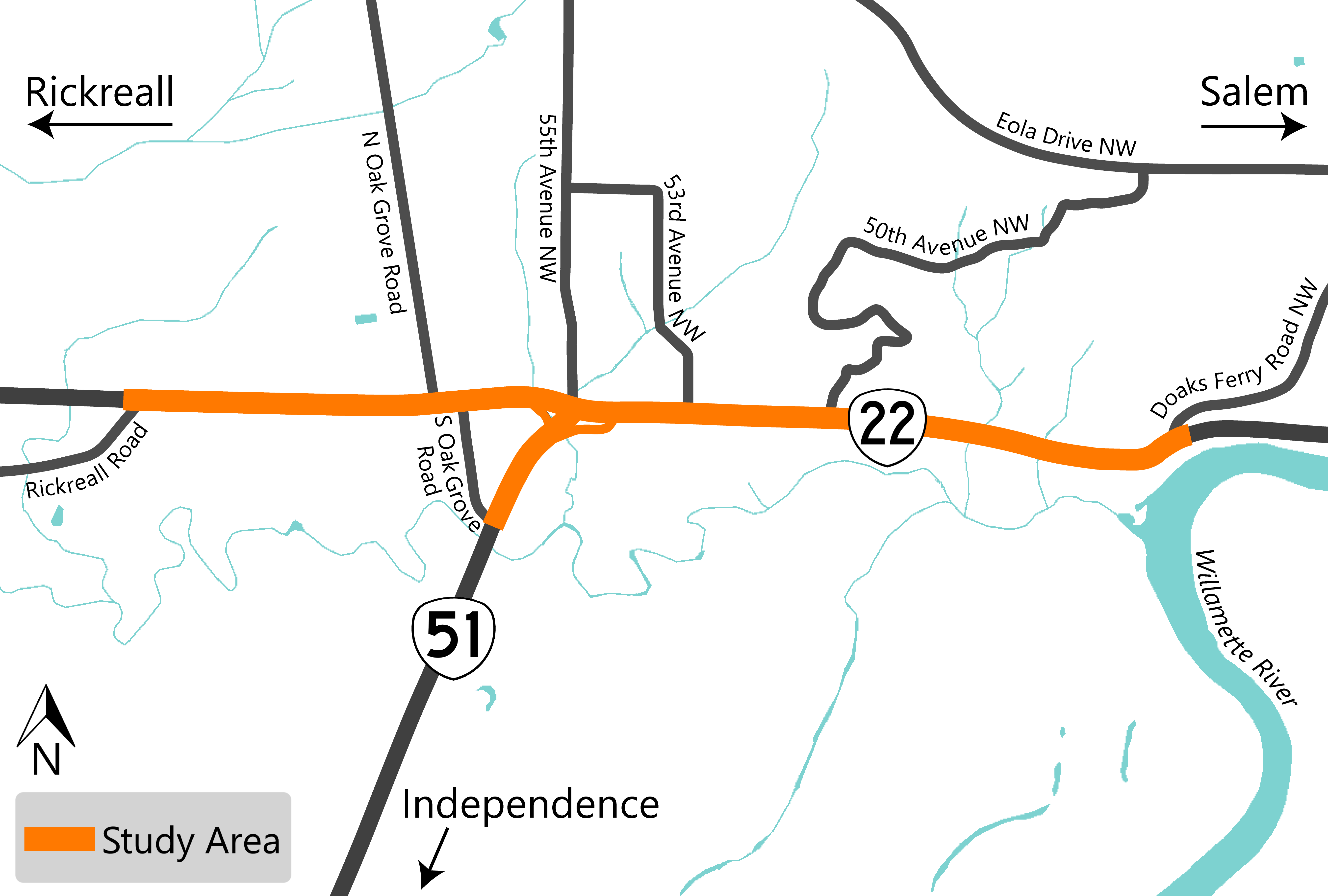
We completed the OR 22W Expressway Management Plan in March 2010. The plan looked at possible solutions to address the safety issues along this corridor but didn't identify preferred options.
The plan found that we need a grade separated interchange at the OR 22 and OR 51 intersection to make the corridor safer. A grade separated interchange means one of the roads crossing over or under the other with ramps to enter and exit the highway.
A Complicated History
![]() In 2015, the first phase of project development was creating an access road to connect Doaks Ferry Road to 50th Avenue NW. This phase of the project had three parts that we were working on with Polk County:
In 2015, the first phase of project development was creating an access road to connect Doaks Ferry Road to 50th Avenue NW. This phase of the project had three parts that we were working on with Polk County:
- Polk County was responsible to realign Doaks Ferry Road NW to Riggs Street NW. This was known as the Doaks Ferry Road Realignment project.
- We were responsible for developing a new road connecting Riggs Street NW to 50th Avenue NW.
- We were responsible for closing driveway accesses to OR 22 between Doaks Ferry Road to Riggs Street NW.
Since 2015, we completed geotechnical monitoring of an ancient landslide. We worked with Polk County on our options and looked for funding. In October 2021, we worked with Polk County and agreed to combine the three separate projects together to review the OR 22 corridor between Rickreall Road and Doaks Ferry Road.
Read our project history document to learn more!
As part of this project we're updating our environmental studies, following the National Environmental Policy Act (NEPA).
What is the National Environmental Policy Act (NEPA)?
NEPA is a federal policy that ensures agencies are looking at the potential impacts of proposed projects and gathering feedback from the affected community. This project has federal funding. Projects with federal funding need to follow NEPA. Learn more about the policy on the Environmental Protection Agency website.
This diagram shows the process that we'll use to evaluate the interchange options. We're in the first phase looking at the environmental, social and economic effects of the project.
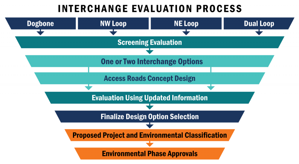
Click on image to enlarge.
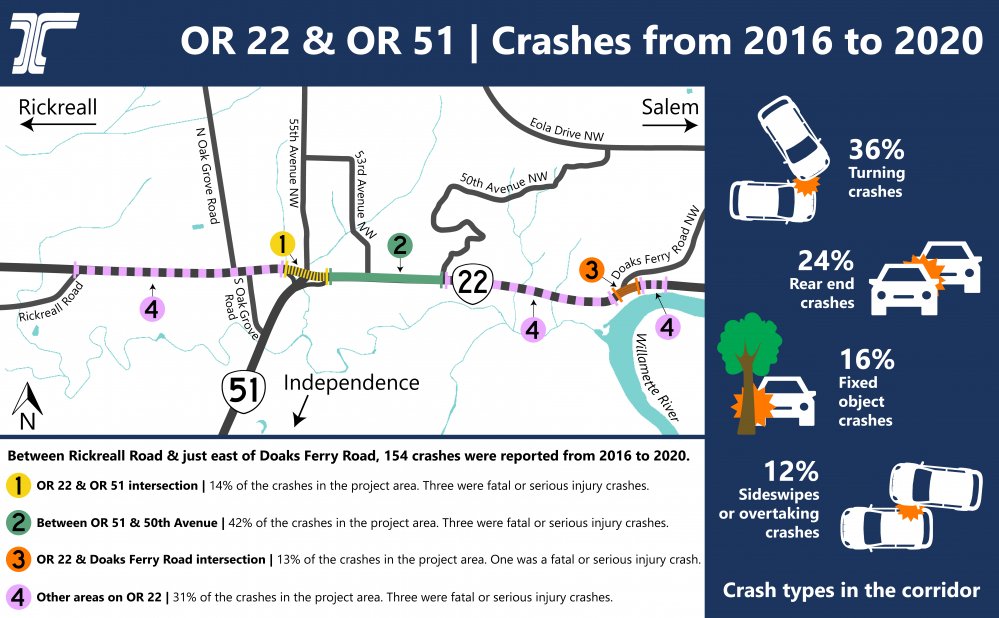
Crashes from 2016 to 2020
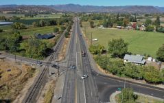
This area can be difficult for drivers trying to get to businesses, access their homes or use local roads. The safety and mobility issues on OR 22 in West Salem are well known. We've been working on the best way to approach these complex issues.
Click on image to enlarge.
Crashes in the corridor
We identified the OR 22 and OR 51 intersection as a priority site due to the high number and severity of crashes.
There have been 154 crashes reported from 2016 to 2020 between Rickreall Road to Doaks Ferry Road.
Most of them happened while making a turn, especially vehicles turning left from OR 22 onto OR 51 and from OR 51 onto OR 22 heading toward the coast.
Of the 154 reported crashes:
- 10 were classified as fatal and serious injury crashes related to or occurring at the OR 22 and OR 51 intersection.
- 55 were turning related, 37 rear end related, 25 fixed object crashes and 19 sideswipe overtaking related.


Screening Evaluation Process
We ranked the four interchange options using the criteria listed above. Our initial results show that the Dogbone interchange and Northwest Loop interchange ranked the highest.
Here are a few reasons why:
- Higher traffic, safety and multi modal performance.
- Lower impacts to private property.
- Less excavation into the hillside.
- Less impact to McNary Creek.
- Lower cost.
Your Feedback is an Important Part of Our Process
Please take a look at the pros and cons of each option below. We'd like to hear from you – please use the comment form in this online open house to share your thoughts about the impacts and benefits of each option. We'll use your feedback to help us narrow down to our top one or two interchange options.
Learn more by clicking on the titles below to expand the boxes.
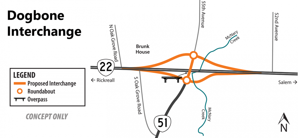
Click on image to enlarge.
Note: The exact alignment of the interchange and access roads hasn't been decided. This drawing is meant to show the possible changes to the area.
About this Option
This is similar to a traditional interchange, with OR 51 traffic on an overpass and OR 22 going underneath. It has exit and entrance ramps that connect directly to OR 51. What makes the dogbone interchange option unique is the back to back roundabouts on each side of the overpass, providing traffic safety and allowing traffic to flow better.
Some examples of an existing dogbone interchange can be seen on:
- I-5 at the Ilani exit in Ridgefield, Washington.
- U.S. 20 and S.R. 2 in Indiana.
Read this article to learn how the Indiana Department of Transportation improved safety in the area by constructing the dogbone interchange. - Richardson Highway in Alaska.
Learn More About the Pros and Cons Based on Our Screening Evaluation
Pros:
- This is the safest interchange option.
- We would need to purchase less property than the other options.
- Low impact on McNary Creek.
Cons:
- The on-ramp is close to the historic Brunk House. The ramp may have a visual impact on the historic house.
- Some utilities will need to be moved.
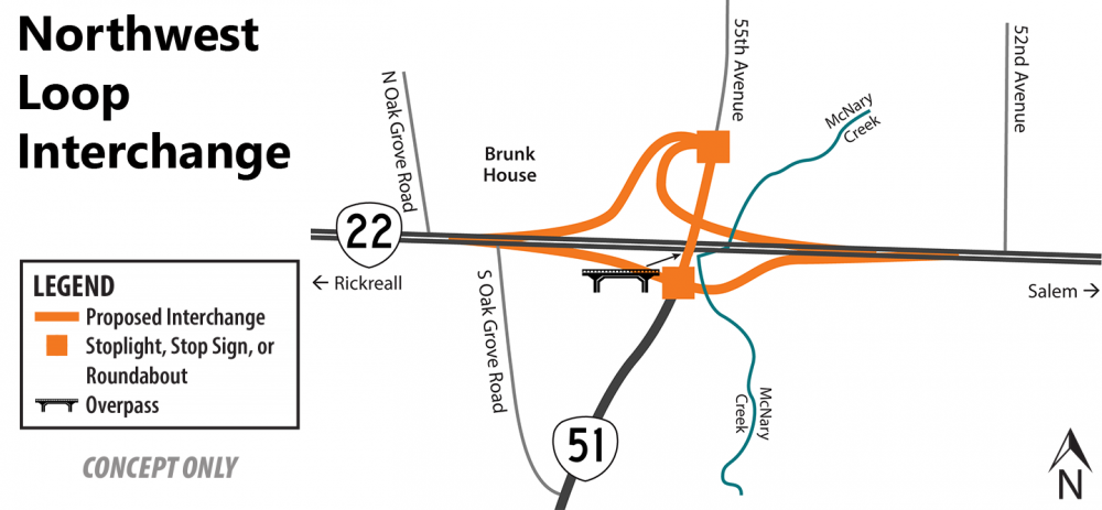
Click on image to enlarge.
Note: The exact alignment of the interchange and access roads hasn't been decided. This drawing is meant to show the possible changes to the area.
About this Option
What makes this interchange unique is the westbound exit loop ramp. On OR 51 and 55th Avenue where the exit and entrance ramps meet, we're looking at either stoplights, stop signs or possibly roundabouts. This option reduces impacts on the hillside north of OR 22 between 55th Avenue and 52nd Avenue.
An example of an existing Northwest Loop interchange can be seen on OR 22 at the Sublimity exit.
Learn More About the Pros and Cons Based on Our Screening Evaluation
Pros:
- Minimizes excavation into the hillside.
- Low impact on McNary Creek.
Cons:
- The on-ramp is close to the historic Brunk House. The ramp may have a visual impact on the historic house.
- This option has more utility impacts, more would need to be moved in the area.
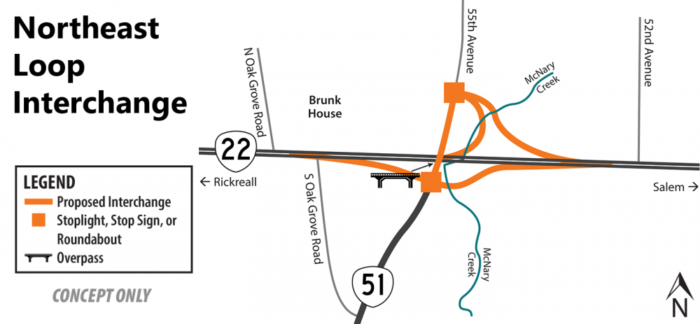
Click on image to enlarge.
Note: The exact alignment of the interchange and access roads hasn't been decided. This drawing is meant to show the possible changes to the area.
About this Option
What makes this interchange unique is the westbound entrance loop ramp. This configuration reduces impacts on cultural resources, such as the Brunk House, west of the interchange.
An example of an existing Northeast Loop can be seen on OR 22 at the Stayton exit.
Learn More About the Pros and Cons Based on Our Screening Evaluation
Pros:
- Fewer utilities would need to be moved.
- Low impact on the historic Brunk House.
Cons:
- We'll need to buy a significant amount of property compared to the other options.
- High impact on McNary Creek.
- Significant excavation into the hillside.
- Traffic movement in the area isn't as good as the other options.
- Difficult for bikes and pedestrians to use.
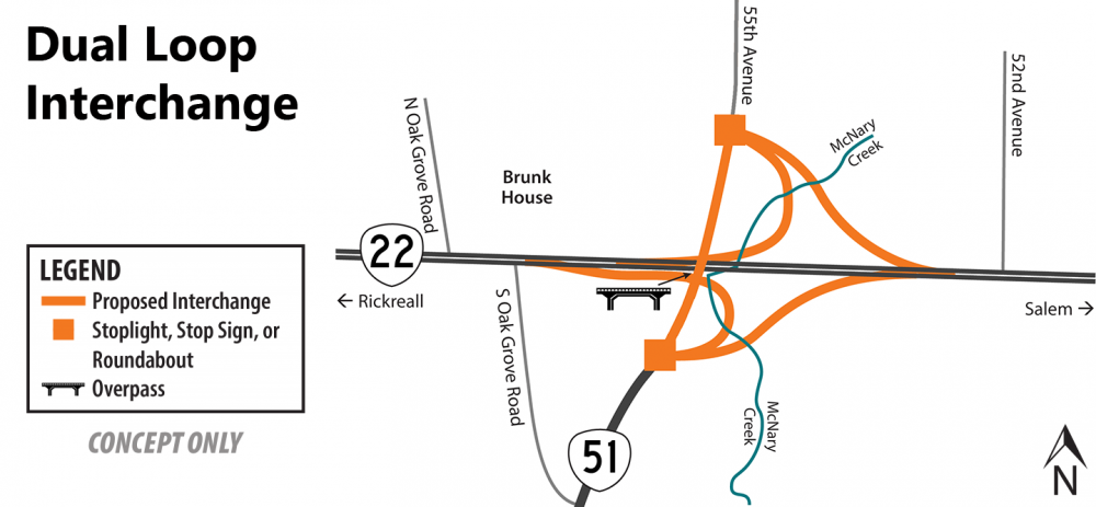
Click on image to enlarge.
Note: The exact alignment of the interchange and access roads hasn't been decided. This drawing is meant to show the possible changes to the area.
About this Option
What makes this interchange unique is the eastbound exit ramp and the westbound entrance ramp.
An example of an existing Dual Loop interchange can be seen on I-5 at exit 238 north of Albany.
Learn More About the Pros and Cons Based on Our Screening Evaluation
Pros:
- Low impact on the historic Brunk House.
Cons:
- Very complex intersection, the lowest safety improvement compared to other options.
- Difficult for bikes and pedestrians to use.
- Would require us to purchase more property than any other option.
- The highest impact out of all of the options to McNary Creek and the hillside in the NE corner.
Map Showing Possible Access Roads
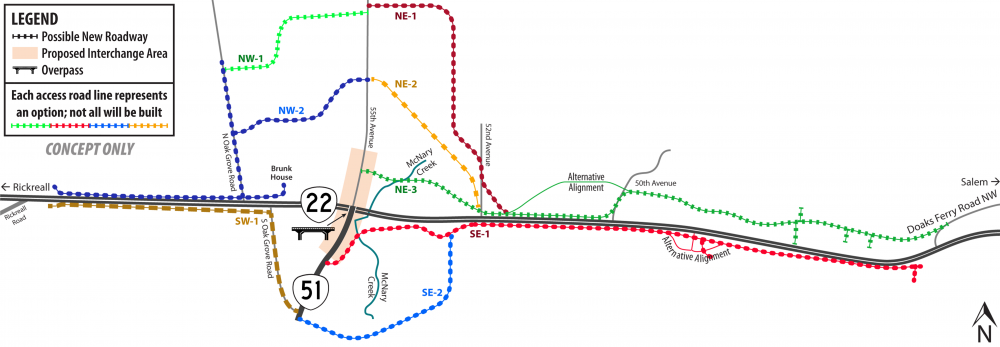
Click on image to enlarge.
Note: The exact alignment of the interchange and access roads hasn't been decided. This drawing is meant to show the possible changes to the area.
Why Add Access Roads?
To make this section of OR 22 safer, a concrete barrier will be installed down the center of OR 22 to prevent left turns. The new concrete barrier will tie into the concrete barrier west of the project.
The access roads will make it safer for drivers to get to businesses and private residences. Access roads will connect to the OR 22 and OR 51 interchange and allow right turns on and off of OR 22 at the east end of the project. The map above shows possible options for access roads. After we have narrowed it down to one or two possible interchanges, we'll be able to work on the access road options. We plan for our final design to have one access road to the north of OR 22 and one to the south.
We Heard You
 Thank you to everyone who responded to our project survey earlier this year. We received about 137 comments! We answered some of the most common questions in a frequently asked questions document – check it out to learn more!
We've also been meeting with business owners to get a better understanding of their experiences in the area. We've learned about the type of vehicles that come to their businesses, how they get deliveries and how they use their property. These meetings have provided helpful information as we work to minimize impacts and out of direction travel.

We Want to Hear From You
Please fill out the comment form below or open in a new window to share your thoughts on the interchange options.
Stay connected
 You can always learn more about the project, find answers to your questions and stay connected by visiting the project webpage.
 If you have not already, sign up to receive future updates about this project.
Please help us spread the word about this online open house.
Feel free to share this with your friends and neighbors so that we can get their feedback.
Thank you for participating!