Additional Information
For ADA (Americans with Disabilities Act) or Civil Rights Title VI accommodations, translation/interpretation services, or more information call 503-731-4128, TTY 800-735-2900 or Oregon Relay Service 7-1-1. Si desea obtener información sobre este proyecto traducida al español, sírvase llamar al 503-731-4128.
Stations
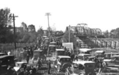
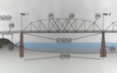

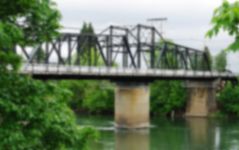
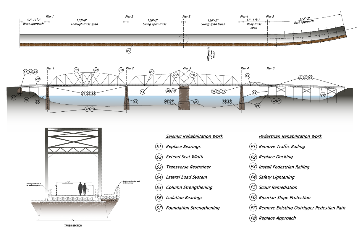
The existing bridge
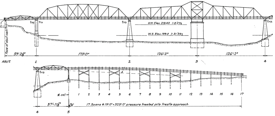
- Year completed: 1915.
- Design features: one lane of motor traffic and a pedestrian path.
- Annual average daily traffic: 10,800 vehicles per day.
- National Bridge Inventory sufficiency rating: 48.9 out of 100. (A score of 50 or less recommends replacement over repair.)
It is being considered for replacement because:
- It’s too narrow to add lanes.
- It’s vulnerable to earthquakes.
- Its rails and transitions are substandard and raise safety concerns.
- A 1995 evaluation recommended it be replaced by 2005 because of steel fatigue. (It is inspected bi-annually as a safety precaution.)
- Recent inspections have noted underwater erosion of its concrete piers and footings.
- Its construction and condition require vehicle height and weight restrictions.
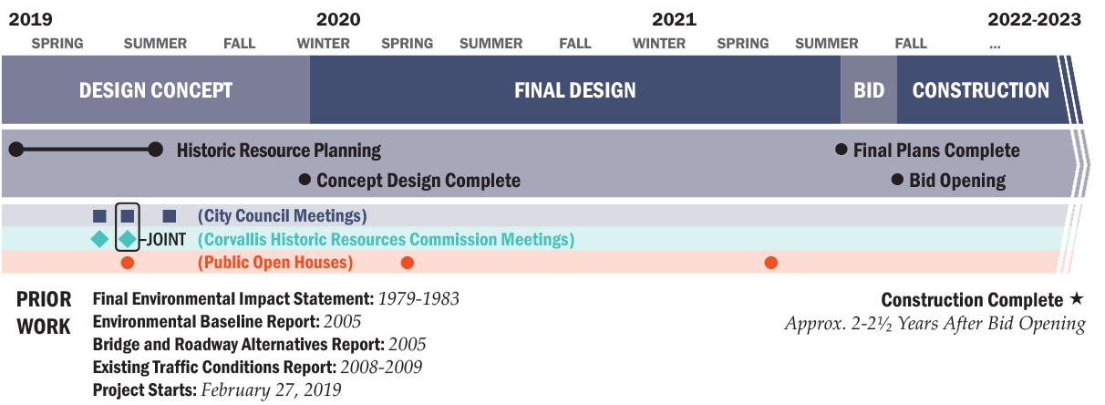
Project history
- 1979-1983: Final Environmental Impact Statement. This study was conducted to consider an alternate route for traffic to bypass the central business area of Corvallis.
- 2004: Plans are revived. By 2006, options include a new bridge parallel to the existing bridge; and a curved bridge between the old bridge and the Harrison Street Bridge. By 2007, an additional option includes a bypass north to connect with Oregon 99W, but no funding is secured.
- 2005: Environmental Baseline Report. Environmental study to assist in determining requirements for the new Van Buren Bridge.
- 2005: Bridge and Roadway Alternatives Report. Design study to assist in locating a new Van Buren Bridge.
- 2008-2009: Existing Traffic Conditions Report. This document focused on conducting additional traffic studies.
- 2017: The State Legislature’s passage of House Bill 2017 augments bridge funding and revives the project’s planning.
This effort will build upon these previous efforts.
Identifying Historic Properties
This effort will include identification of historic properties within the project area through field survey and background research; assessment of potential effects to historic resources that are identified; and the resolution of adverse effects to historic resources, if needed. These efforts will be conducted with consultation from the Oregon State Historic Preservation Office, project stakeholders, and the general public. A Historic Resource Baseline Report has already been conducted and will inform further identification of historic properties. Additionally, a revalidation will occur for the previously-documented Corvallis Downtown Historic District which has the potential to be affected by the project and features resources not situated within the project Area of Potential Effect (APE). The public is encouraged to submit historical information for resources within the APE and within the potential historic district.
Historic Resources Future Efforts
Once the prudent and feasible alternative is chosen pursuant to Section 4(f) of the Department of Transportation Act and design efforts are underway, the process of assessing effects to properties that have been determined eligible for listing in the National Register of Historic Places (NRHP) can begin. Where possible, avoidance and minimization of impacts to eligible resources will be incorporated. ODOT will consult the State Historic Preservation Office, project stakeholders, and the general public on all findings.
Please provide any feedback you may have in the comment portion of this open house as well as any historic resource specific questions to:
Hayli Reff, ODOT Region 2 Architectural Historian
503-986-2654, Hayli.reff@odot.state.or.us
API/APE Map
Click and drag to explore the map. Click lines, shapes and icons for more information. Turn layers on and off and browse the list of projects by clicking the ![]() button in the upper left of the map window. (You may need to turn off layers to select other objects underneath.) Map shapes and icons are provided for reference only, precise locations may vary.
button in the upper left of the map window. (You may need to turn off layers to select other objects underneath.) Map shapes and icons are provided for reference only, precise locations may vary.
Learn more about the Historic Resources Baseline Report Survey Report Results.
How are the 2005 alternatives being considered in this process?
The previous alternative analysis done in the 2005 Bridge and Roadways Concepts Report took a look at a wide range of alternatives. Yet recognizing that work is almost 15 years old and per the requirements of the USDOT, which insures that a current and relevant set of alternatives is considered whenever there is potential for a removal of a nationally significant historic bridge, ODOT is validating the conditions, assumptions and analysis that led to those alternatives – including the following:
- Alternative A: Widening the Harrison Bridge
- Alternative B: Retrofitting and Retaining the Existing Bridge
- Alternative C: Building a Southern Bridge
What to do with the existing bridge?
With the utilization of federal funds, this project requires compliance with Section 106 of the National Historic Preservation Act, a procedural law that requires agencies to consider the effects on historic properties. A Bridge Repurposing Study will look at the alternatives for use of the existing bridge.
This Bridge Repurposing Study investigates the need for a new bridge and the possible outcomes of the existing bridge, should the City or other 3rd party choose to take ownership of the existing bridge at its present or relocated location. Additional project alternatives not listed in this document and not directly related to City or 3rd party ownership of the existing bridge are being concurrently examined or revalidated.
Alternatives
The three alternatives presented in the Bridge Repurposing Study are:
- Alternative 1: Repair it for walking, biking and more,
- Alternative 2: Relocating the existing bridge, and
- Alternative 3: Dismantle it.
You can learn more about each of these three options on the following pages.
Tradeoffs and Considerations
- If a new bridge is decided, it will have separated paths for biking and walking, so the existing bridge won’t be required for pedestrians to cross the river.
- The existing bridge would need to be carefully analyzed to verify the capacity of the structure to carry pedestrian loads.
- To safely accommodate pedestrians on the existing bridge, it would need to be modified. This would require removing the existing sidewalk to prevent its use, and retrofitting the main travel lane to incorporate pedestrian safety railing and loading requirements.
- The approach spans would need to be replaced to make room for the replacement bridge and create new access to the existing bridge.
- A bridge would likely be built at a higher elevation to provide the minimum navigable channel required by the United States Coast Guard (USCG) with the unintended consequence of obstructing northward views from the existing bridge.
Costs
Construction: Approximately $12 million
Annual maintenance: Approximately $150,000

Tradeoffs and Considerations
Five theoretical locations in the city were considered for cost estimating purposes. The actual future location would need to be determined by any future owner.
Along with the cost of moving, the bridge spans would need:
- A new deck and safety railings.
- Site preparation, with a wide range of related costs depending on the selected site.
Costs
Construction: Estimated between $7 million to $10.2 million (including a temporary work bridge and removal of the existing bridge’s underwater piers and footings), depending on the new location.
Annual maintenance: Approximately $145,000
Possible Relocation Areas
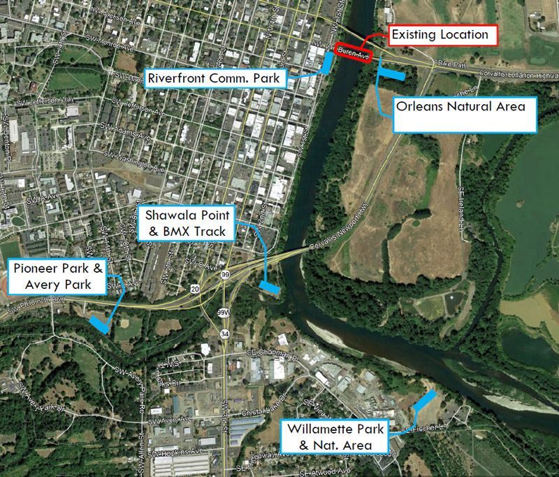
These five theoretical locations were studied for cost estimation purposes. The actual location will be determined by the future owner .
Example
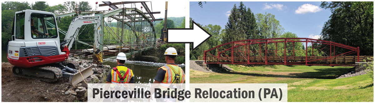
Photos: McCormick Taylor
Tradeoffs and Considerations
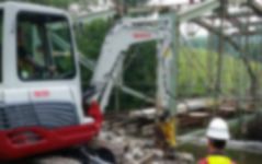
If demolition of the existing bridge is identified as the appropriate course of action, the cost of removing the existing structure will be incorporated into the construction package of building the new bridge. The anticipated length of time to complete demolition work is less than one year.
Costs
Demolition: Over $4 million (mobilization, work bridge construction, debris containment measures, and removal of bridge components)
Annual maintenance: $0
Stay Involved
Complete the comment form below.
Visit the project website for more information.
Sign up for email updates.
Contact ODOT: Savannah Crawford, (541) 757-4154
Timeline