We want to hear from you.
Thank you for taking the time to learn more about this study.
After reviewing our ideas for improvements on OR 226 and OR 22, please share your thoughts in our survey. Your feedback helps us develop the right types of improvements for each city.
Stations
Click on the "+" or the title below to view the information in each section.
This effort, also known as an “urban design verification” (UDV) study, will identify lower-cost improvements that can be made for people biking and walking. Improvements might include new signs, marked crossings, pedestrian-activated signals, sidewalks, crosswalks, bike lanes and more.
We're studying these highways now so we can have improvements identified before future maintenance or other road improvement projects are planned. Once we have an idea of potential improvements, we can look for opportunities to include or bundle them with other necessary work to make the best use of our limited resources.
For example, if we have a project to update sidewalk curb ramps, we may be able to also improve pedestrian crossings with new striping and signs that make it safer to cross the street. The completed study can also be used to help find funding for future projects through grants or other opportunities. Identifying potential improvements now will make it easier to implement them as opportunities arise.
Potential future projects could be:
-
Safe Routes to School Projects.
-
Maintenance projects.
-
ADA projects – add sidewalks, ramps or paving.
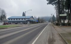
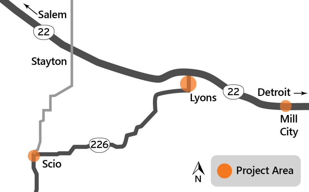 We are studying two specific sections of OR 226 and one section of OR 22.
-
Scio
OR 226 (S Main Street and Albany-Lyons Highway), from 6th Avenue to SE Ash Street. -
Lyons
OR 226 (Albany-Lyons Highway), from 6th Street and Main Street to North City Limits/Santiam River Bridge. -
Mill City
OR 22 (N Santiam Highway), from NE 3rd Avenue to NE 7th Avenue.
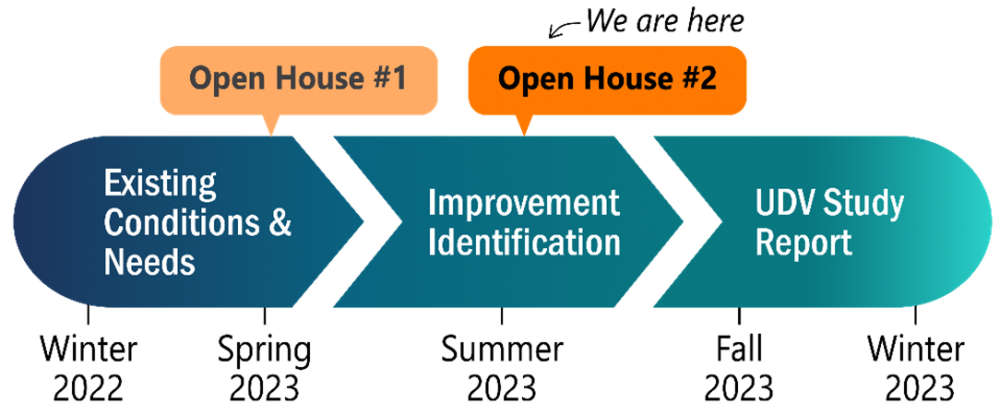
We have several opportunities for you to weigh in on the study in 2023:
We hope you can stop by! Please let us know if you need accommodations to attend.
-
This online open house, open through August 6, using the survey.
-
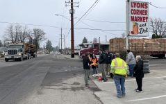
Talk with us at one of our in-person events:
-
Mill City 4th of July Celebration | Kimmel Park, 525 SE Fairview Street, Mill City
Tuesday, July 4, 1 p.m. - 3 p.m.
Accessible parking is available on the right-hand side of the parking lot. -
Lyons Flea Market | Santiam Valley Grange, 1140 5th Street, Lyons
Saturday, July 15, 11 a.m. - 1 p.m.
The accessible entrance is on the side of the building. -
Scio National Night Out | Scio Fire Station, 38975 SW 6th Avenue, Scio
Tuesday, August 1, 6 p.m. - 8 p.m.
Accessible parking is available at the front of the building.
-
-
Sign up to receive notifications about projects on OR 22 and projects in Stayton, Lyons and Scio.
-
We expect to complete the study by the end of 2023.

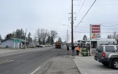
The project area in Scio follows OR 226 for approximately 0.3 miles, from SW 6th Avenue to SE Ash Street. Most of this segment is on Main Street and one block is on SE 1st Avenue.
Below is a summary of identified issues, let us know in the survey if we missed any:
-
Sidewalks
The existing sidewalks are narrow, disconnected or don't exist. Some sidewalks are at street level and have drainage issues. -
Crosswalks
The area lacks ADA-compliant curb ramps. The south end of the corridor does not have a marked crosswalk. -
Bike Lanes
Bike lanes or other comfortable spaces to bike are missing in the project area. Existing bike lanes start on Main Street immediately north of OR 226. -
Shoulders
The shoulders are paved and relatively wide in places. -
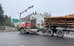
Freight
Freight trucks commonly use OR 226.
Location map

Click on the "+" or the title below to view the information in each section.
Thank you for sharing your experiences with us in our April 2023 survey. We learned more about what issues and needs are important to the community. We'll share comments that were outside of our project area with our local maintenance crews and partners.
We developed draft improvement ideas for the corridor to address these needs. These ideas are concepts and are still being developed. We'll refine these ideas based on community feedback. To make sure our ideas are right for your community we need to hear what you think — fill out the survey after reviewing the ideas!
These proposed improvements are intended to make it feel more comfortable and safer to walk and bike through Scio. The improvements would comply with our guidelines and Scio’s Comprehensive Plan. Proposed improvements could be constructed with other projects that are on the horizon, such as paving and ADA sidewalk enhancements.
Learn more about our ideas by clicking on the tabs below.
Sidewalks
We would add new sidewalks to create a continuous sidewalk connection on both sides of OR 226 from SW 6th Street to the bridge, and from S Main Street to SE Ash Street. Existing sidewalks with drainage issues would be upgraded with new sidewalks that meet current standards.
Bike lanes
We would add new bike lanes to create a dedicated place to bike along both sides of OR 226 from SW 6th Street to the bridge, and from S Main Street to SE Ash Street.
Crosswalks
A new marked crosswalk would be added at SW/SE 4th Avenue. Existing marked crosswalks at SW/SE 2nd Avenue, SE 1st Avenue and SE Ash Street would be enhanced with ADA-compliant ramps to sidewalks at their ends.
Parking
There is limited space on the roadway, so parking on the shoulders would be removed south of SW/SE 2nd Avenue on S Main Street. Parking would be maintained on the east side of S Main Street between 1st Avenue and SW/SE 2nd Avenue (in front of the auto parts store). Parking would also be maintained on both sides of SE 1st Avenue between S Main Street and SE Ash Street.
Freight
The potential improvements would continue to accommodate trucks along this important freight route.
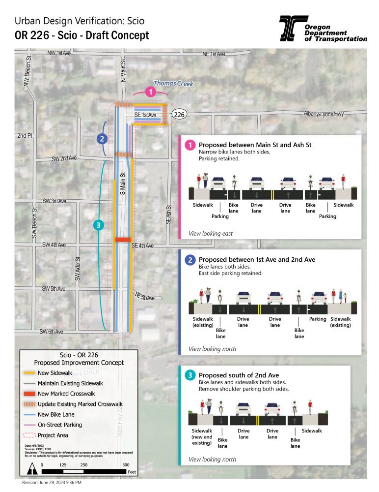
Click on the image to enlarge.
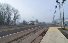
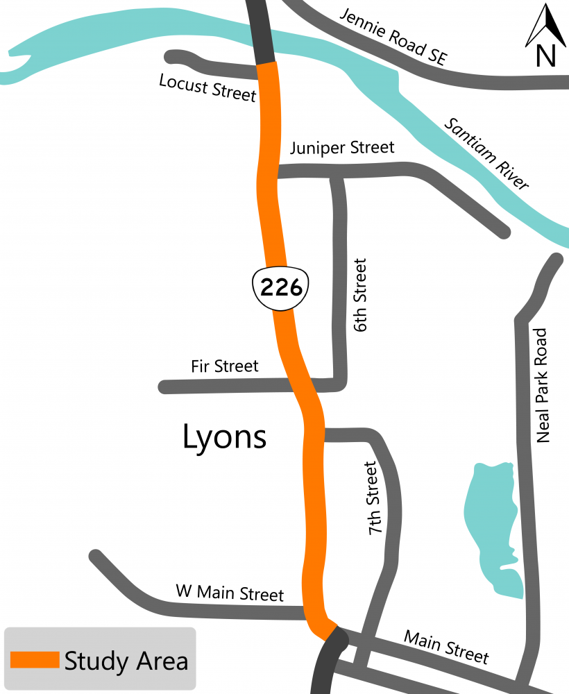
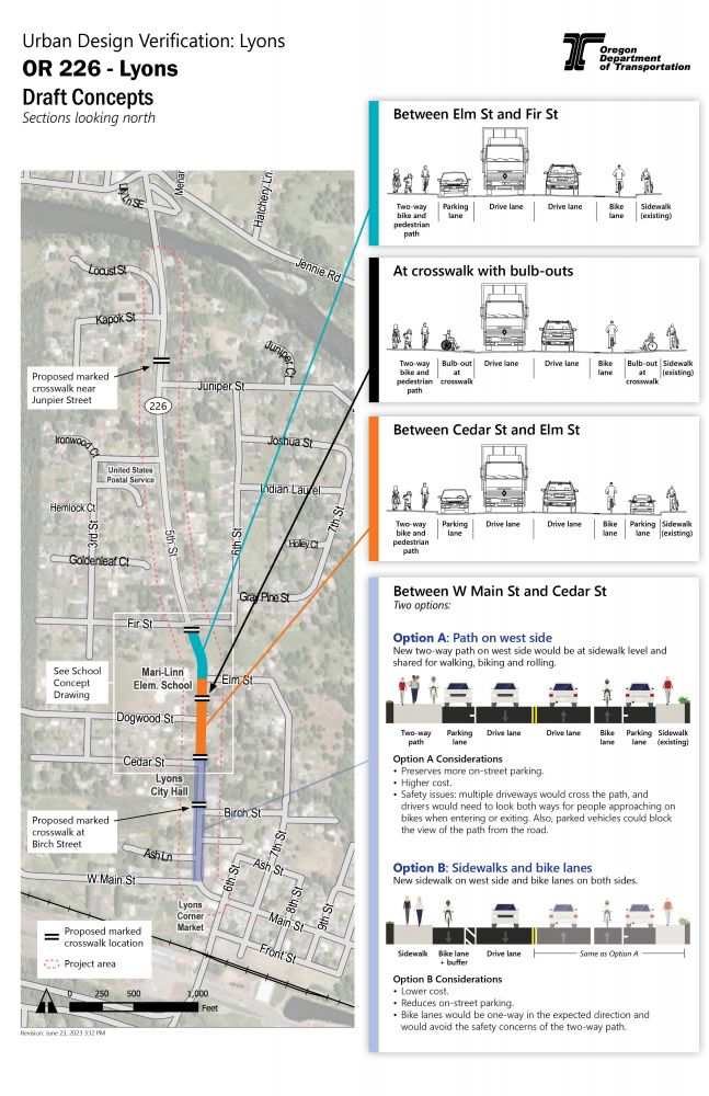
The project area in Lyons follows OR 226 for approximately 1.03 miles, from 6th Street to the north city limits (Santiam River bridge). This segment is primarily on 5th Street (Albany-Lyons Highway) with one block on Main Street (at the south end).
Below is a summary of identified issues, let us know in the survey if we missed any:
-
Sidewalks
The existing sidewalks are narrow and not fully connected on the west side of OR 226, south of the Mari-Linn Elementary School. -
Crosswalks
There are two marked crosswalks in the project area, one on 6th Street and one near Dogwood Street. They are approximately 1,600 feet apart and they don't have ADA-compliant curb ramps. -
Bike Lanes
There are no dedicated bike lanes in the project area. -
Shoulders
The shoulders are paved and relatively wide in places. -
Freight
Freight trucks commonly use OR 226.
Location map
Click on the "+" or the title below to view the information in each section.
Thank you for sharing your experiences with us in our April 2023 survey. We learned more about what issues and needs are important to the community. The most common themes we heard were:
- Desire to add sidewalks where currently missing.
- Concern about the number and speed of large trucks.
- The desire for more enhanced crosswalks.
- Concern for safety at the intersection of OR 226, Main Street and 6th Street.
We developed draft improvement ideas for the corridor to address these needs. These ideas are concepts and are still being developed. We'll refine these ideas based on community feedback. To make sure our ideas are right for your community we need to hear what you think — fill out the survey after reviewing the ideas!
These proposed improvements are intended to make it feel more comfortable and safer to walk and bike along OR 226 through Lyons. The improvements would enhance the safe connections to Mari-Linn School and would comply with our guidelines by providing facilities that serve walking and biking. Proposed improvements could be constructed with the Safe Routes to School grant as well as with other projects that are on the horizon, such as paving and ADA sidewalk enhancements.
Learn more about our ideas by clicking on the tabs below.
Connected sidewalks
We would add a new walking and biking path on the west side that would connect with the existing sidewalks to create a continuous walking route along the corridor.
Bike lanes
We would add new bike lanes combined with a new walking and biking path that would create a dedicated place to bike along both sides of OR 226 from W Main Street to Fir Street. Bike lanes also encourage safer driving by narrowing the traffic lanes and reminding drivers that they are traveling through a community.
Crosswalks
New marked crosswalks would be added at Juniper Street, Fir Street, Cedar Street and Birch Street. The existing marked crosswalk at Dogwood Street would be moved north closer to the Mari-Linn School entrance and would have a rapid flashing beacon. All marked crosswalks would have ADA-compliant ramps and could have bulb-outs (also called “curb extensions”).
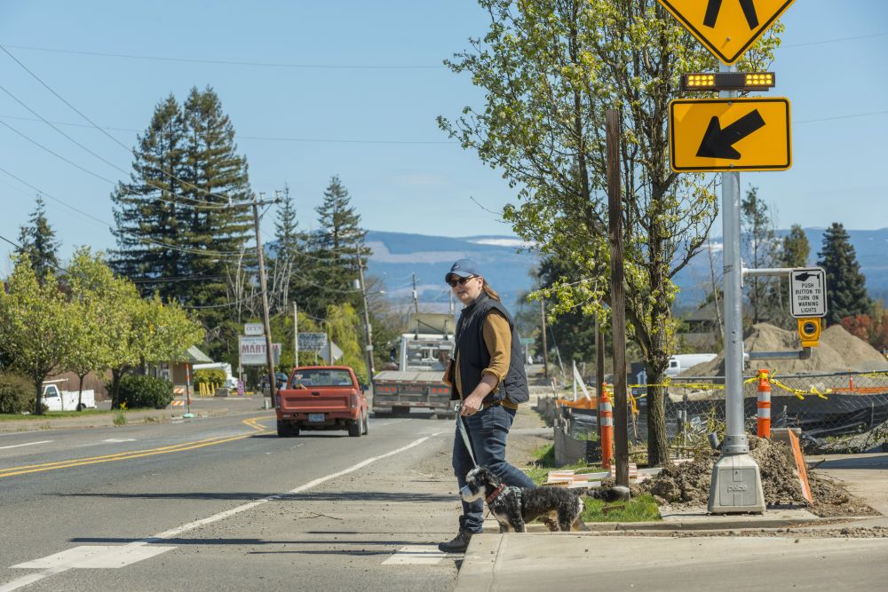
A flashing beacon alerts drivers that someone wants to cross the road.
(Photo source: ODOT via Flickr)
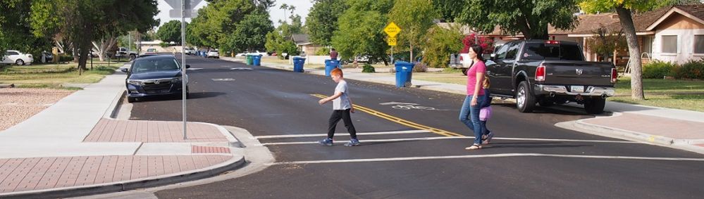
Curb extensions shorten the distance people have to walk to cross the road. They also make it easier for drivers to see pedestrians and encourage slower driving speeds.
(Image source: Maricopa Association of Governments)
Parking
Parking would be retained in most places between Cedar Street and Elm Street. Because of limited roadway space, parking would be on only one side of the road between Elm Street and Fir Street and between Cedar Street and Main Street.
Freight
The potential improvements would continue to accommodate trucks along this important freight route.
We want to hear from you!
We have two options for the roadway between W Main Street and Cedar Street, and we need your feedback to help identify which is best for the community.
- Option A would have a new two-way path on the west side. The path would be at sidewalk level and shared for walking, biking and rolling. This option would retain more on-street parking, but would cost more and introduces some safety issues.
- Option B would have a new sidewalk on the west side and bike lanes on both sides. This would cost less but would reduce the amount of on-street parking.
Click on the image to enlarge.
The project area in Mill City follows OR 22 (NE Santiam Boulevard) for approximately 0.2 miles, from NE 3rd Avenue to NE 7th Avenue.
Below is a summary of identified issues, let us know in the survey if we missed any:
-
Sidewalks
Most of the project area doesn't have sidewalks. -
Crosswalks
There are no marked crosswalks in the project area. -
Biking
There are no dedicated bike lanes in the project area. -
Shoulders
The existing shoulders are wide and partially paved and gravel. -
Freight
OR 22 is commonly used for truck traffic and is a state-designated freight route. Weekend traffic is heavy with people traveling to and from the mountains.
Location map

Click on the "+" or the title below to view the information in each section.
Thank you for sharing your experiences with us in our April 2023 survey. We learned more about what issues and needs are important to the community. Most comments were related to safety on OR 22, including:
- Desire for sidewalks.
- Concern about a lack of crosswalks.
- Concern about how it feels unsafe to bike on OR 22.
- Suggestion for speed cameras on OR 22 to encourage safer driving.
We developed draft improvement ideas for the corridor to address these needs. These ideas are concepts and are still being developed. We'll refine these ideas based on community feedback. To make sure our ideas are right for your community we need to hear what you think — fill out the survey after reviewing the ideas!
These proposed improvements are intended to make it feel more comfortable and safer to walk and bike along OR 22 through Mill City. The improvements would comply with our guidelines by providing facilities that serve walking, biking and freight trucks. Proposed improvements could be constructed with other projects that are on the horizon, such as paving and ADA sidewalk enhancements.
Learn more about our ideas by clicking on the tabs below.
Sidewalks
We would add new sidewalks to create a continuous sidewalk along one side of OR 22. Sidewalks would be constructed as project opportunities arise or along with new development. Steep slopes on the sides of the highway would make new sidewalks in some areas very expensive and impactful.
Bike lanes
New bike lanes create a dedicated place to bike along both sides of OR 22 from NE 3rd Avenue to NE 7th Avenue. Bike lanes also encourage safer driving by visually narrowing the drive lanes and reminding drivers that they are traveling through a community.
Crosswalks
New marked crosswalks would be added at NE 5th Avenue and, with future development, at NE 7th Avenue. These crosswalks will provide comfortable places to walk, bike, or use a mobility device across the highway. The crosswalk at NE 7th Avenue would be especially valuable in the future with new development north of OR 22 and with the extension of the trail along the Santiam River south of OR 22.
Parking
There is limited space on the roadway, so parking on the shoulders would be removed through the corridor.
Freight
The potential improvements would continue to accommodate trucks along this important freight route.
Click on the image to enlarge.

Stay Connected
 You can always learn more about the project, find out about upcoming events and stay connected by visiting the project webpage.
 If you have not already, sign up to receive future updates about projects on OR 22 and projects in Stayton, Lyons and Scio.
Please help us spread the word about this online open house.
Feel free to share this with your friends and neighbors so that we can get their feedback.
Thank you for participating!