OR 18: Fort Hill Road Project Area
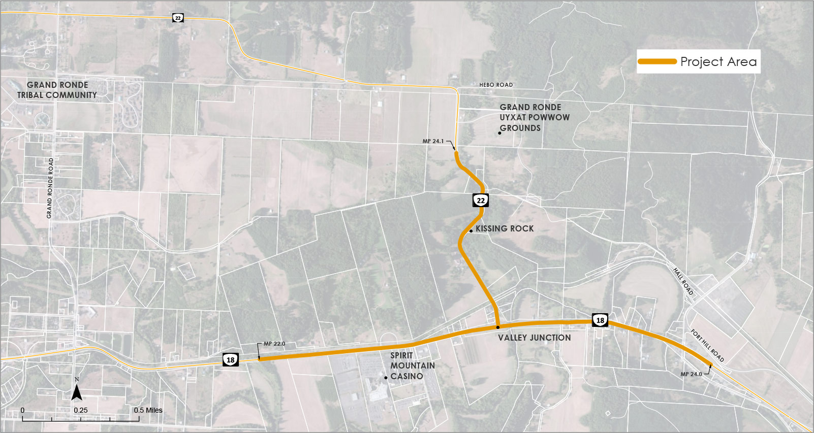
(Click on image to enlarge.)
Stations
The need for this project was identified in the 2004 H.B. Van Duzer Forest Corridor to Steel Bridge Road Environmental Assessment and Corridor Refinement Plan due to safety and congestion concerns. In this plan, an interchange is proposed at the OR 18 and OR 22 Valley Junction intersection. This project is taking a fresh look at the Phase 2 information studied in the Environmental Assessment and Corridor Refinement Plan.
The project Steering Committee, which includes representatives from the Oregon Department of Transportation, the Confederated Tribes of Grand Ronde and Polk County, developed a project purpose statement and six project goals to guide the project. The intent of this work was to help the project team compare potential design concepts and evaluate what works best for this location and the community.
Project Purpose Statement:
The purpose of the OR 18: Fort Hill Project is to enhance safety, reduce congestion and improve mobility on OR 18 from west of Spirit Mountain Casino to Fort Hill Road interchange and on OR 22 from the Valley Junction intersection north, past Kissing Rock.
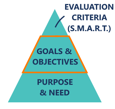 Project Goals:
These goals were identified through early discussions with the Steering Committee.
- Safety.
- Multimodal mobility.
- Community and equity.
- Cost and implementation.
- Resiliency.
- Environment.
The evaluation criteria and steps are outlined in the upcoming stations.
Note: S.M.A.R.T. stands for specific, measurable, attainable, relevant and time-bound.
Through the outreach we’ve done to date, the following needs were identified:
- OR 18 experiences heavy traffic in the project area.
- Summer weekend traffic is especially heavy, creating considerable delays especially if there is an incident.
- The amount of traffic on OR 18 makes it difficult for drivers to turn left from OR 22/Hebo Road onto OR 18.
- Freight traffic has been using alternatives instead of OR 18, which can pose safety issues on local roadways.
- More crashes are happening with drivers crossing over the middle line into oncoming traffic or rear-ending cars ahead of them.
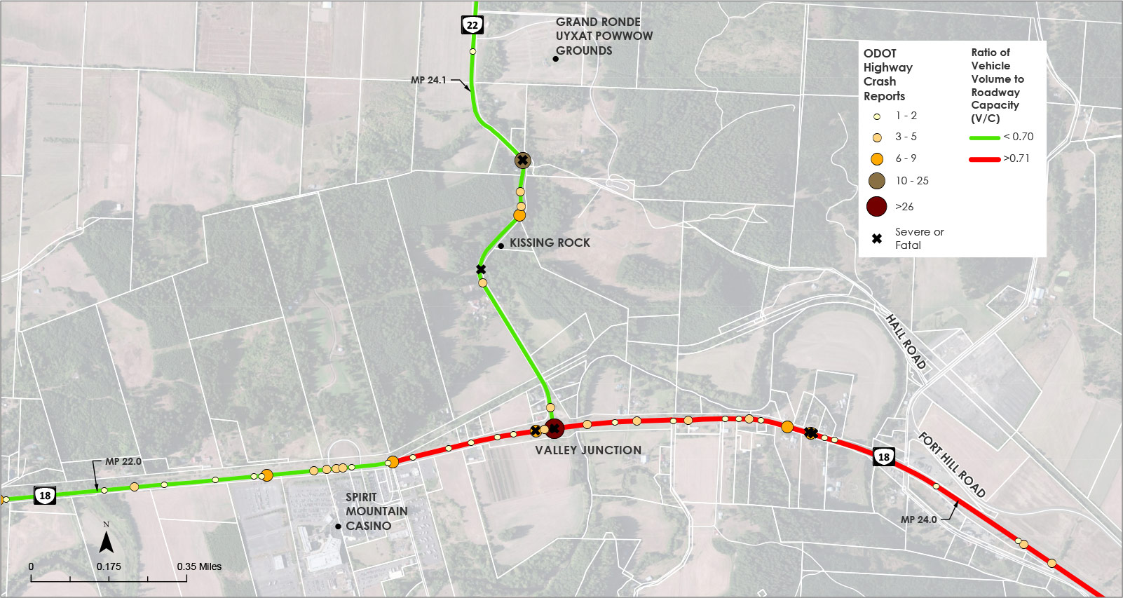
Traffic Safety and Congestion Conditions
We have seen how crashes and traffic congestion can be a problem on OR 18. This map shows the locations of crashes from 2015-2019 and the level of traffic congestion. We used this information to help inform the design concepts that you will review later in the open house.
Congestion and Crash Reports in Project Area: 2015-2019
(Click on image to enlarge.)
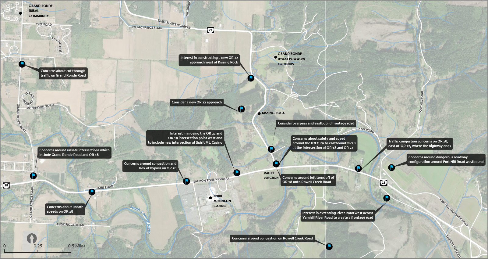
Existing Conditions Feedback
Knowing what the data tells us about traffic safety and congestions is important, but understanding the experiences of the community is critical in shaping the outcome of this project. This map below shows a summary of comments collected from our initial round of public feedback earlier this year, when we asked about problems and concerns people experienced.
We heard about:
- Unsafe speeds.
- Unsafe intersections.
- Ideas to adjust the roadway alignments.
- Ideas to provide increased local access at certain points.
We used this feedback to make sure our design concepts were addressing the needs we heard from the community.

Below are the main elements in the design concepts that address the project purpose and goals:
OR 18 Roadway Widening
Our design concepts widen OR 18, including the roadway and bridges, to four lanes to match the number of lanes that OR 18 has east of the project area.
Having two lanes for each direction will help improve traffic flow by increasing capacity. Adding a median barrier between the east and west lanes improves safety by not allowing vehicles to cross into oncoming traffic.
An Interchange for OR 22 at OR 18Our design concepts recommend replacing the Valley Junction intersection of OR 22 at OR 18 with a new interchange. This can be accomplished by using the existing interchange, such as the one at the Spirit Mountain Casino, or build a new interchange. See the connectivity concepts information below to learn what this may look like.
An interchange at the current Valley Junction intersection would reduce turning movement issues, allowing drivers to safely access the Spirit Mountain Casino.
OR 22 ImprovementsChanging the highway connection could improve how travelers move through the area, especially trucks. By softening the sharp curves near Kissing Rock, visibility and mobility could make this highway more useable to OR 22 truck traffic.
Project Focus Areas
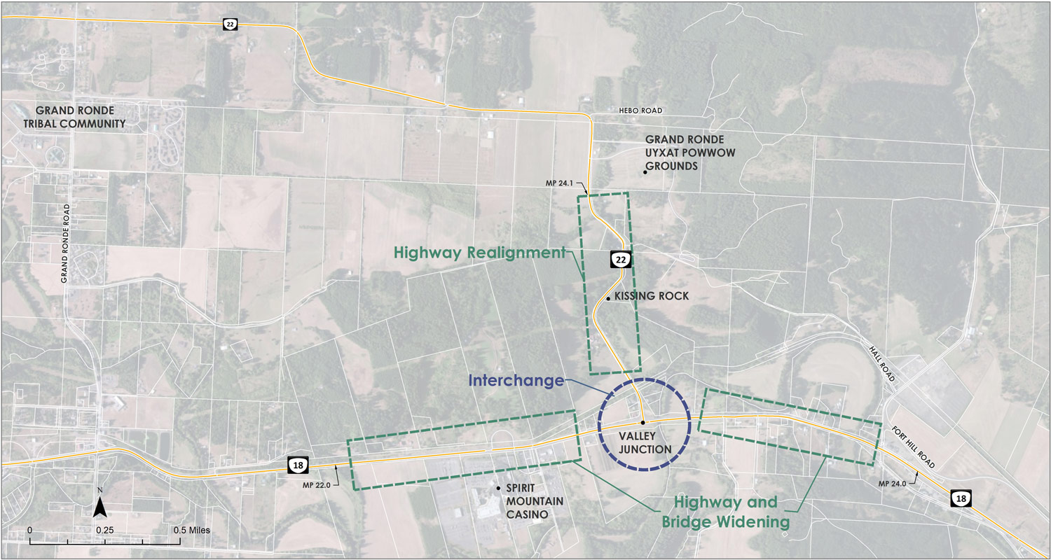
(Click on image to enlarge.)
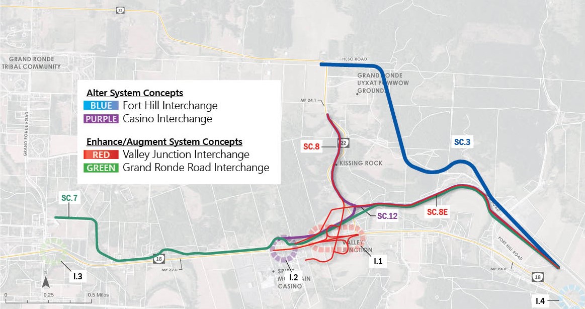
- Concepts that alter the system by rerouting OR 22 away from the Valley Junction intersection to the existing OR 18 and Fort Hill Road interchange (shown on the map below in blue and labeled SC.1, SC.3, SC.4, SC.5, SC.6, SC.10 and SC.11).
- Concepts that enhance or add to the existing system by realigning OR 22 through the Kissing Rock area and using a potential new interchange at either Valley Junction (shown on the map below in red and labeled SC.0, SC.2, SC.8, SC.8E, SC.8W, SC.9), the existing Spirit Mountain Casino interchange (shown on the map below in purple and labeled SC.12) or Grand Ronde Road (shown on the map below in green and labeled SC.7).
The map below shows all of the concepts initially considered.
System Connectivity Concepts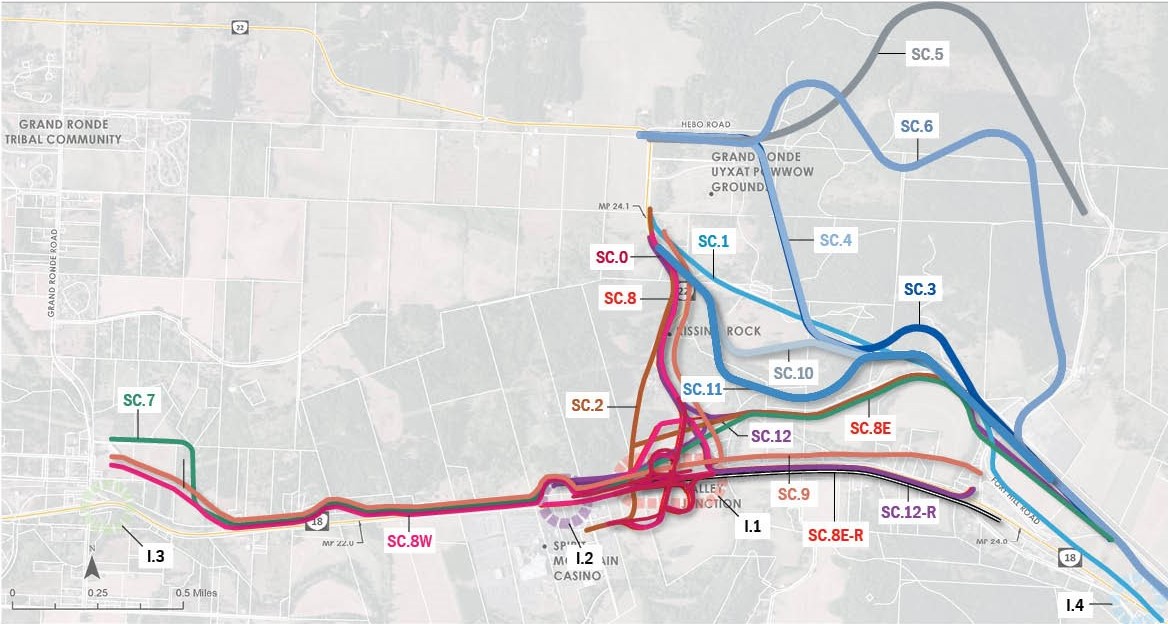
(Click on image to enlarge.)
We evaluated each of these concepts based on how they met our project goals to narrow it down to our top design concepts.
Our analysis found that the Valley Junction concepts that enhance the system (shown in red) were the most promising. More details on the evaluation criteria used to score the concepts, which led us to the top concepts shown in the map below, can be found here.
As we continue working on the design concepts, we will consider additional issues such as interchange location, local connections, improvements for people walking and bicycling and access management.
Top System and Continuity Concepts
(Click on image to enlarge.)
Feedback Our Most Promising Concepts
The following are the most promising project concepts that weigh project goals and issues. All concepts have improved travel time and designs that reduce crashes in the project area. They are still only ideas and will need further planning, analysis and engineering. The final design concept should meet the project goals by balancing the needs of community members, local businesses, freight movement and travelers passing through the area.