For ADA (Americans with Disabilities Act) or Civil Rights Title VI accommodations, translation/interpretation services, or more information call 503-731-4128, TTY 800-735-2900 or Oregon Relay Service 7-1-1.
Stations

Why is an IAMP needed?
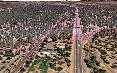
The US 97/Baker Road interchange is about thirty years old. When it was constructed, it served sparsely developed rural lands south of Bend and accommodated freight traffic passing between US 97 to the south and US 20 to the east. Bend's population is now nearly four times greater, and the urban growth boundary is anticipated to abut the interchange within the next 20 years.
Increasing urban growth has resulted in congestion and safety issues in the interchange area, and there are limited facilities for people walking or biking. These issues will intensify as housing and employment growth in Bend continues to move towards the interchange. To address these issues, the IAMP will help to keep the US 97/Baker Road interchange functioning well for the next 20 years by:
-
Ensuring the safe and efficient operation of the interchange area for people driving, walking, biking and using transit through the next 20 years.
-
Identifying transportation improvements, management strategies and land use/policy actions needed to support planned development.
Study Area Map
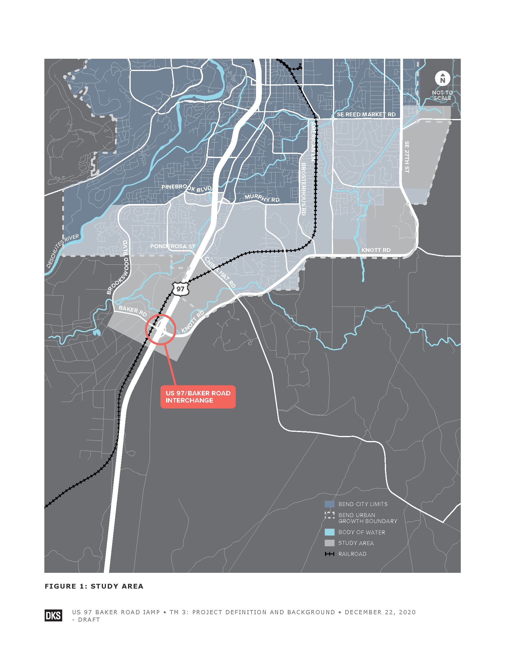
(Click to enlarge.)
The study area includes areas where changes in land use would have measurable traffic volume impacts at the US 97/Baker Road interchange. When setting the study area boundaries, the team considered the proximity of the interchange to locations where significant future housing and employment growth are expected. Future growth immediately to the northeast and further east out to SE 27th Street is expected to have a significant impact on interchange traffic volumes.
Project Timeline
The project started at the end of 2020 and is anticipated to be complete in spring 2022.
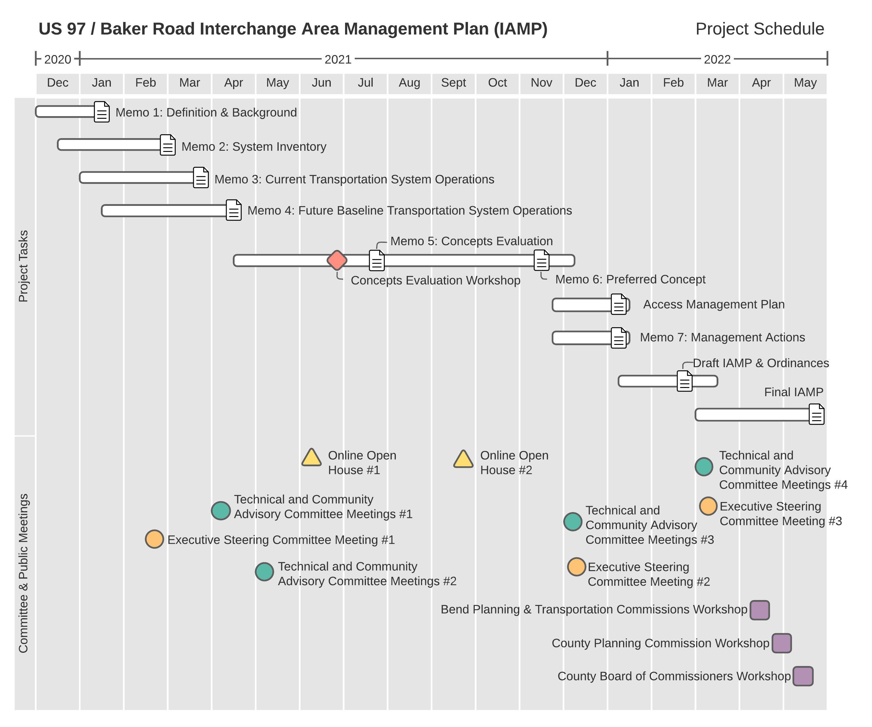
(Click to enlarge.)
Community Outreach
-
It is a project priority to engage all community members in this process. The project team is reaching out to those who are historically underrepresented to ensure broad community perspectives are heard and considered.
-
The project will host a second online open house this fall to review the draft plan and proposed improvements.
-
A project Community Advisory Committee is meeting four times to review project materials and provide feedback. The committee membership represents a diverse spectrum of local interests. Meetings are open to the public. You can find meeting information and materials on the project website.
-
Sign up to receive emails for Central Oregon projects.
The project’s draft goals and objectives help guide the development of this plan for the interchange area and will evaluate how the solutions meet the project purpose and stakeholder values. Click on the icons below to learn more about the project objectives.
 Goal 1: Provide for efficient travel through the interchange area based on existing and planned land uses in the area
 Objective A: Provide for efficient travel along US 97.
Objective B: Provide for efficient travel on the local roadway system near the interchange.
 Goal 2: Improve safety for all modes of travel
Objective A: Reduce the frequency and severity of crashes for all.
Objective B: Improve access spacing along US 97, Baker Road, and Knott Road, or meet the standards where feasible.
 Goal 3: Support regional and local economic development
Objective A: Maintain access to properties along Baker Road and Knott Road to support the economic development objectives of existing and future businesses consistent with the Deschutes County and Bend Comprehensive Plans.
Objective B: Design the interchange to facilitate freight movement along US 97 and to and from the east.
Objective C: Allow for safe and uninterrupted service on the railroad.
 Goal 4: Facilitate the use of multimodal travel options
Objective A: Provide comfortable walking and biking facilities that create east-west connectivity through the interchange area.
Objective B: Identify where planned trails in the interchange area can be incorporated into this plan.
Objective C: Accommodate long-term connectivity to the south.
Objective D: Support future enhancements to transit service.
 Goal 5: Develop the project to support the community’s value of equity
Objective A: Provide an equitable decision making process that encourages participation by all.
Objective B: Achieve a just allocation of burdens and benefits among community members.
 Goal 6: Practice good stewardship of the environment
Objective A: Reduce vehicle emissions through reduction of vehicular delay, improved connections to the local roads, and the use of alternative travel modes.
Objective B: Minimize impacts on resource lands.
Objective C: Minimize adverse impacts on wildlife.
 Goal 7: Develop solutions that are consistent with the established shared corridor vision and adopted state and local plans
Objective A: Create a US 97 corridor that is compatible with the recommendations from the US 97 Parkway Plan and Bend to Lava Butte Refinement Plan.
Objective B: Ensure compatibility with future planned growth in Bend’s opportunity and expansion areas.
Objective C: Consider the visual sequence of project elements as an entry/exit node to the City of Bend.
Objective D: Support the action plan in the Greater Bend Community Wildfire Protection Plan to enhance community safety.
 Goal 8: Develop implementable solutions for the interchange area
Objective A: Minimize impacts on resource lands.
Objective B: Ensure public funds are invested efficiently and effectively, and solutions are fiscally responsible.
Objective C: Develop solutions that can be implemented in phases.
Objective D: Develop a design that is constructable and could be reasonably maintained.
Current Traffic Control and Travel Lanes
-
All intersections are controlled with stop signs.
-
No left turn lanes on Baker Road/Knott Road.
Current Traffic Operations/Congestion
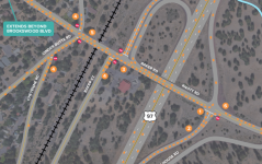
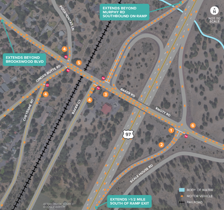
Mobility targets are a tool used to identify deficiencies and solutions around the movement of vehicles on state roadways. The state’s policy is to maintain reliable and acceptable levels of mobility considering the type of roadway and its location. The graphic below illustrates areas that currently meet and do not meeting these targets for mobility.
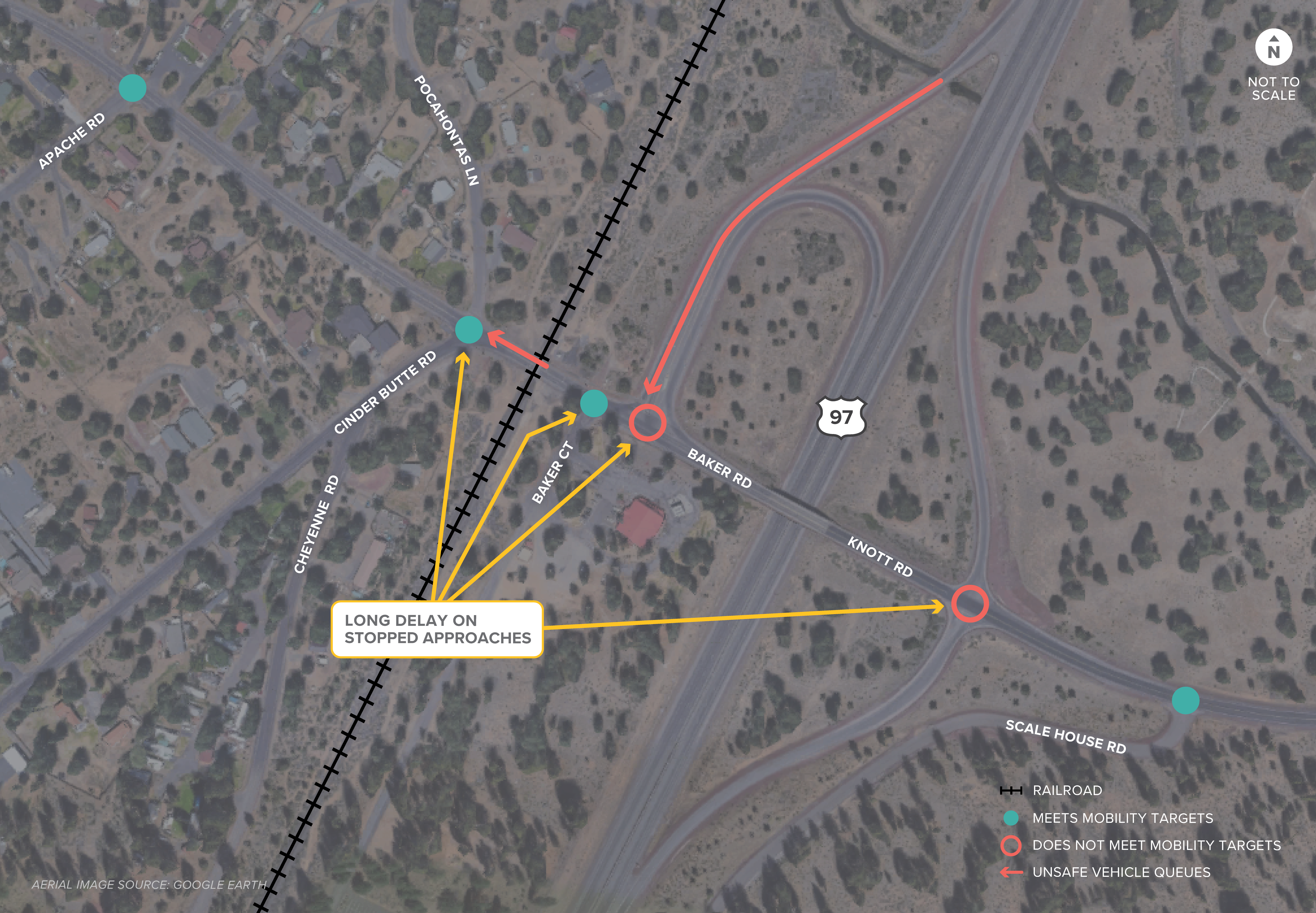
(Current interchange traffic operations. Click to enlarge.)
-
Currently, both ramp terminals are experiencing significant congestion with long delays on the stopped approaches.
-
Cinder Butte Road and Baker Court meet mobility targets but stopped approaches still experience long delays.
-
Queues on the southbound off-ramp back up near or to the highway.
-
The westbound left queue to Cinder Butte Road backs across the railroad.
-
Queues can block closely spaced intersections.
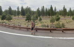
Current Walking, Biking and Transit Facilities
-
There are no sidewalks or bike lanes near the interchange and limited sidewalks and bike lanes along China Hat Road.
-
The Baker Road Interchange is the only way to safely cross US 97 for people walking or biking in the area (Murphy Road is two miles north).
-
Baker/Knott Road is a designated County Bikeway and commonly used for recreational cycling.
-
Future growth to the east, as well as planned trails, will create more walking and biking demand.
-
There is one bus stop for Route 30 at the River Woods Outreach Church, but congestion through the interchange area makes it difficult for drivers to stay on schedule.
Current Railroad Crossing
-
At-grade railroad crossing on Baker Road, west of the southbound ramps.
-
Up to eight train crossings/day (no passenger service).
-
Average train crossing closes the road for about one minute and 50 seconds.
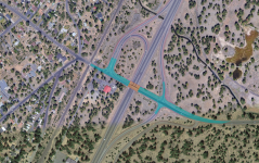
Current Safety/Risk Factors
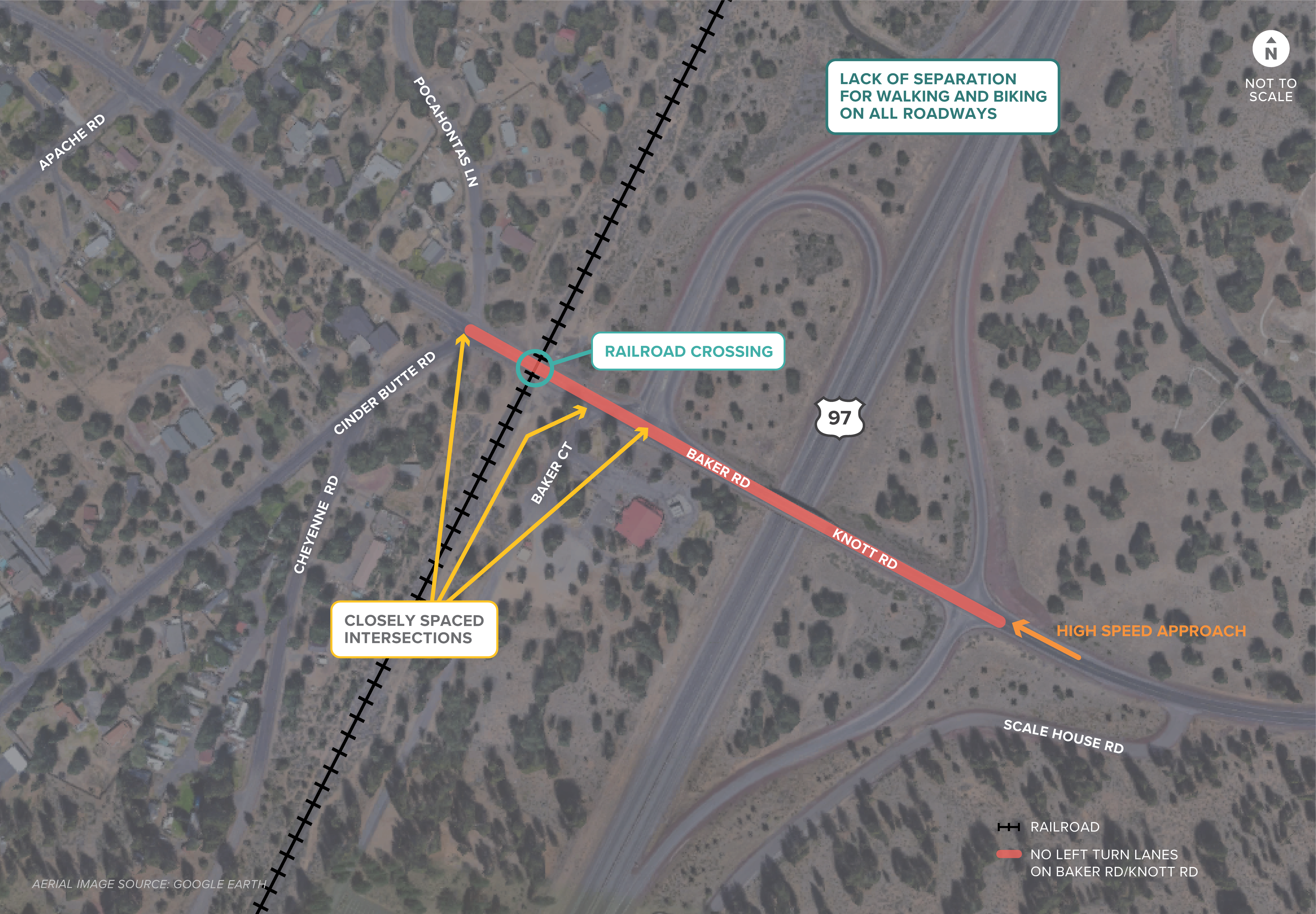
(Overview of current safety/risk factors identified at the interchange. Click to enlarge.)
-
People walking and biking on shoulders are exposed to high-speed traffic.
-
Closely spaced intersections create turning conflicts and confusion.
-
The lack of left-turn lanes on Baker/Knott Roads causes stops in traffic and increases the potential for rear-end collisions.
-
Traffic approaching the interchange from the east is often traveling at high speeds.
-
Cars sometimes back up across the railroad tracks.
After looking at current conditions, the team evaluated how the interchange will operate with the projected growth in the area, with already planned improvements. This information helps us determine which components of the interchange need improvement. Key takeaways follow.
Future Projected Housing and Employment Growth
There are three major expansion areas to the east of the interchange that are anticipated to include over 2,400 households and over 7,000 jobs by 2040.
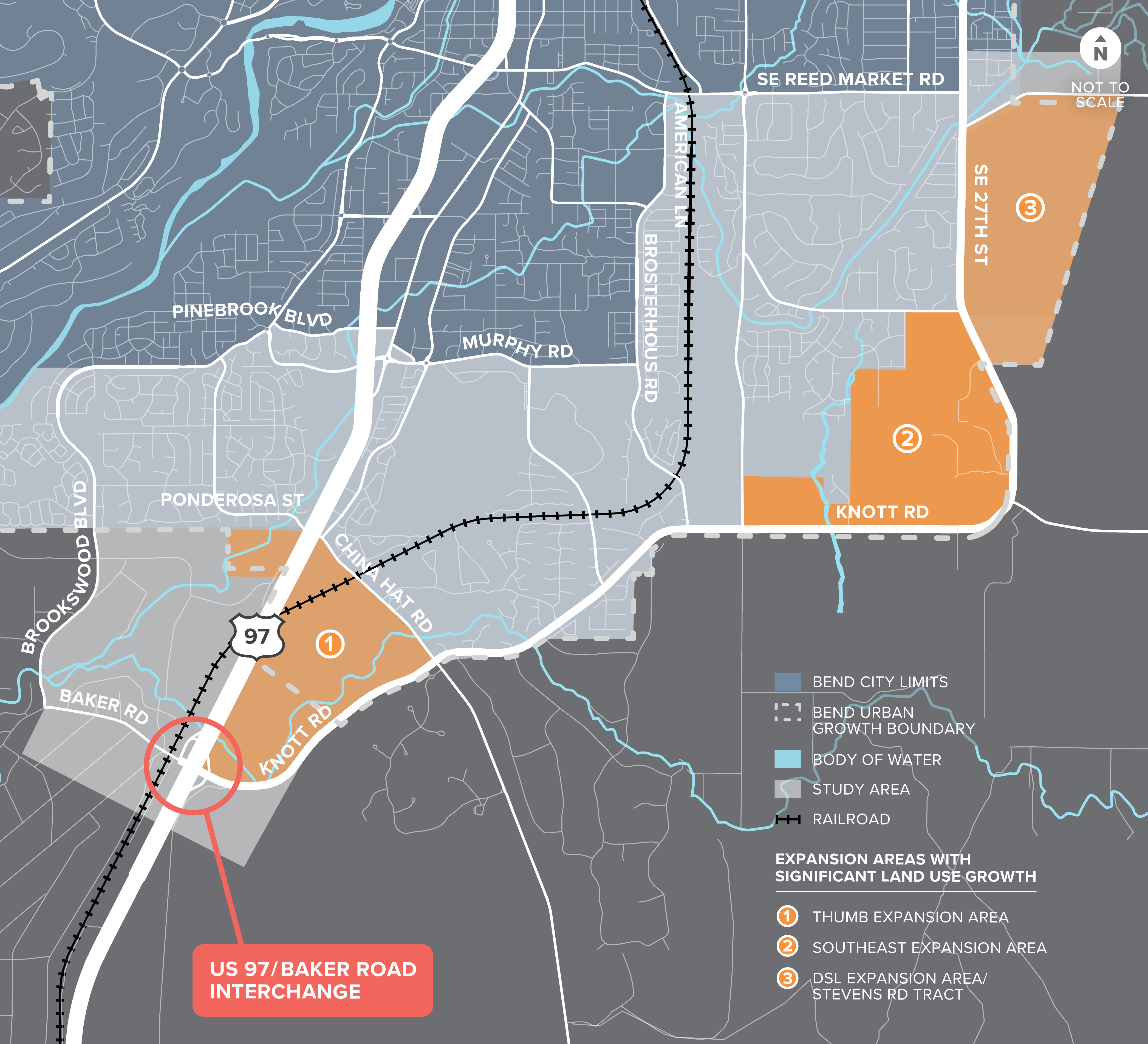
(Projected expansion areas in the project area. Click to enlarge.)
Planned Transportation Improvements Assumed to Be in Place by 2040
-
US 97/Murphy Road northbound on-ramp and southbound off-ramp.
-
Closure of right-on/right-off direct connections to US 97 at China Hat Road, Ponderosa Street and Rocking Horse Court.
-
China Hat Road overcrossing of US 97 and realignment of Parrell Road/China Hat Road intersection.
-
Frontage road along the west side of US 97 connecting the China Hat Road overcrossing to Murphy Road.
-
China Hat Road/Knott Road roundabout.
Future Growth Impacts on Traffic
Most traffic growth through the interchange by 2040 will be from trips to and from the east.
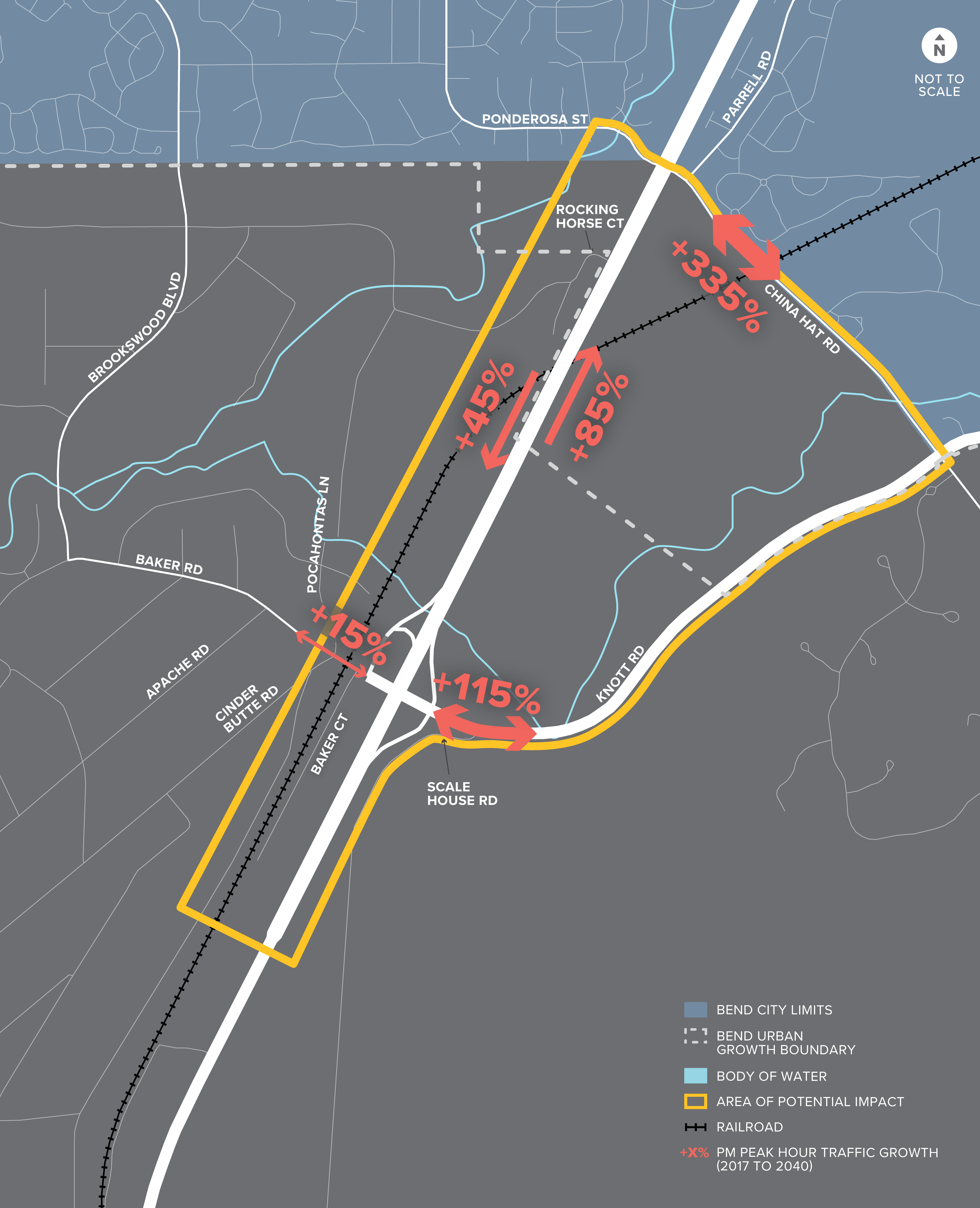
(Future traffic growth on major roadways. Click to enlarge.)
(Growth impacts in 2040 at the interchange during p.m. peak hour. Click to enlarge.)
Explore the details of the map below.
 In the future, there is significant growth in eastbound traffic (to access new land use in the “thumb” area). Without a separate left-turn lane, eastbound left-turn vehicles block the through lane and cause extensive eastbound queuing on Knott Road/Baker Road (extending beyond Brookswood Boulevard).
 Because of the issue noted in (1) above, there are effectively no safe gaps in traffic for northbound left-turning vehicles to enter Knott Road. The northbound left queue eventually blocks the northbound right turn lane and queues back to the US 97 mainline.
 The eastbound queue at the US 97 northbound ramp extends beyond the US 97 southbound ramp. This blocks southbound left-turning vehicles from entering Knott Road/Baker Road. The southbound left turn queue eventually blocks the southbound right turn lane and queues back to the US 97 mainline. Note that even if the eastbound queue at the US 97 northbound ramp did not extend to the US 97 southbound ramp, it is likely that the queue for the southbound left turn would still block access to the southbound right turn lane.
 Since the eastbound queue at the US 97 northbound ramp extends through all of the study intersections, significant queueing develops on all of the side street approaches on Baker Road because they are unable to turn out unless another driver lets them in.
 Even though the queueing and congestion on the US 97 ramps limit the amount of westbound traffic that can reach Cinder Butte Road/Baker Road, the lack of a westbound left-turn lane causes the westbound approach to back up to the railroad tracks. Without constraints at the ramp terminals, this queue would likely extend farther.
 Without a separate westbound right turn lane, vehicles slowing to make a westbound right turn cause westbound queues to extend nearly to Scale House Road.
In addition to impacts on traffic flow, conditions for people walking and biking through the area will worsen and become more uncomfortable and unsafe. This congestion will also negatively impact the ability for transit vehicles to stay on schedule.
The team is currently developing options to improve the functionality of the interchange as the surrounding area develops using the project’s goals and objectives as their guide. They will then evaluate and refine these options and review potential environmental impacts. Review and comment on the refined options at the next online open house later this year!
Review early concepts below.
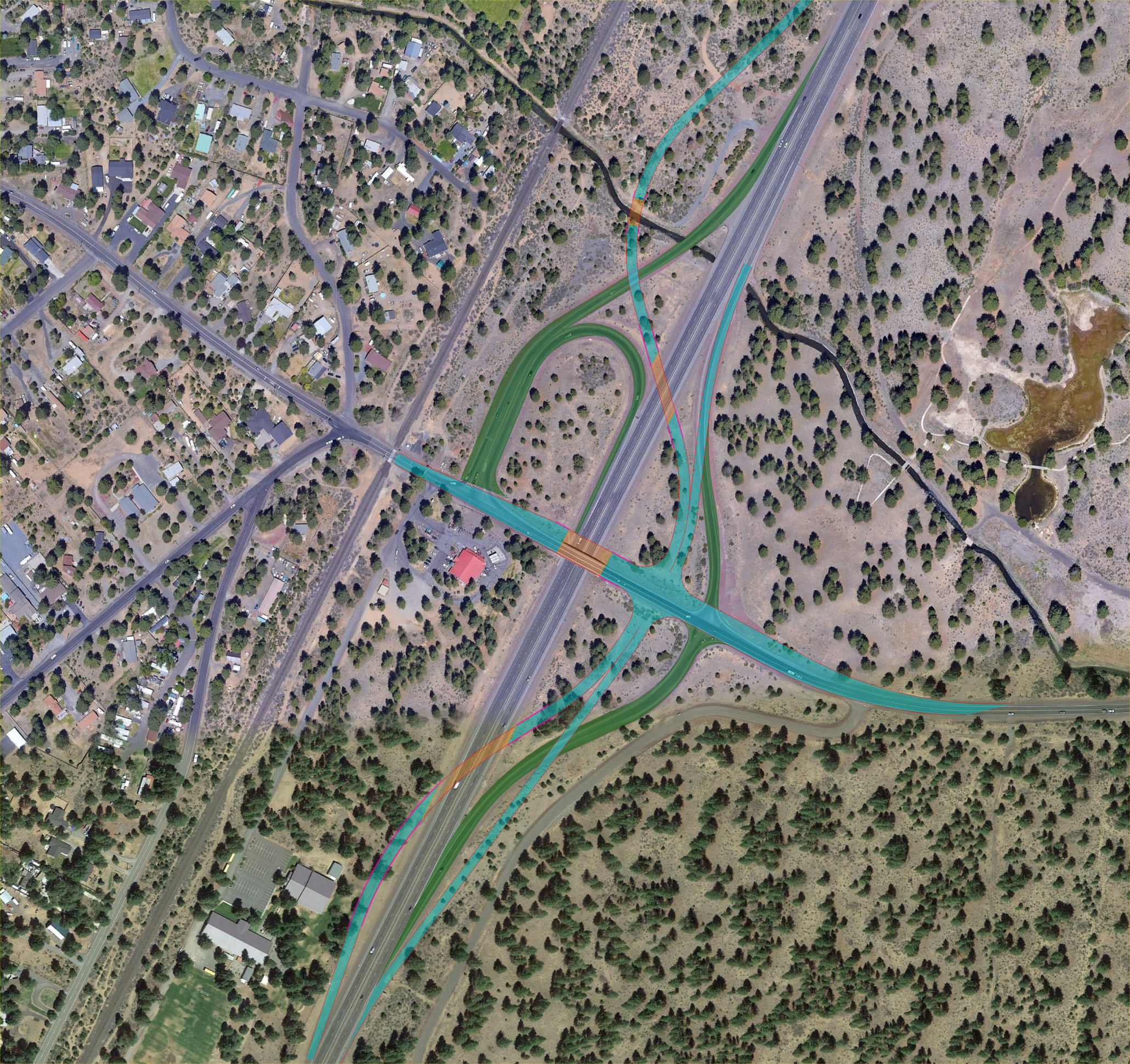
Alternative 1 – Low Build
Maintain existing interchange configuration with additional improvements
-
Widen existing structure
-
Provide additional travel lane
-
Provide raised multi-use path adjacent to eastbound travel lane
-
Buffered bike lane adjacent to westbound travel lane
-
-
Intersection improvements at ramp terminals
-
Add capacity
-
Additional turn lanes
-
Potential new traffic signals
-
-
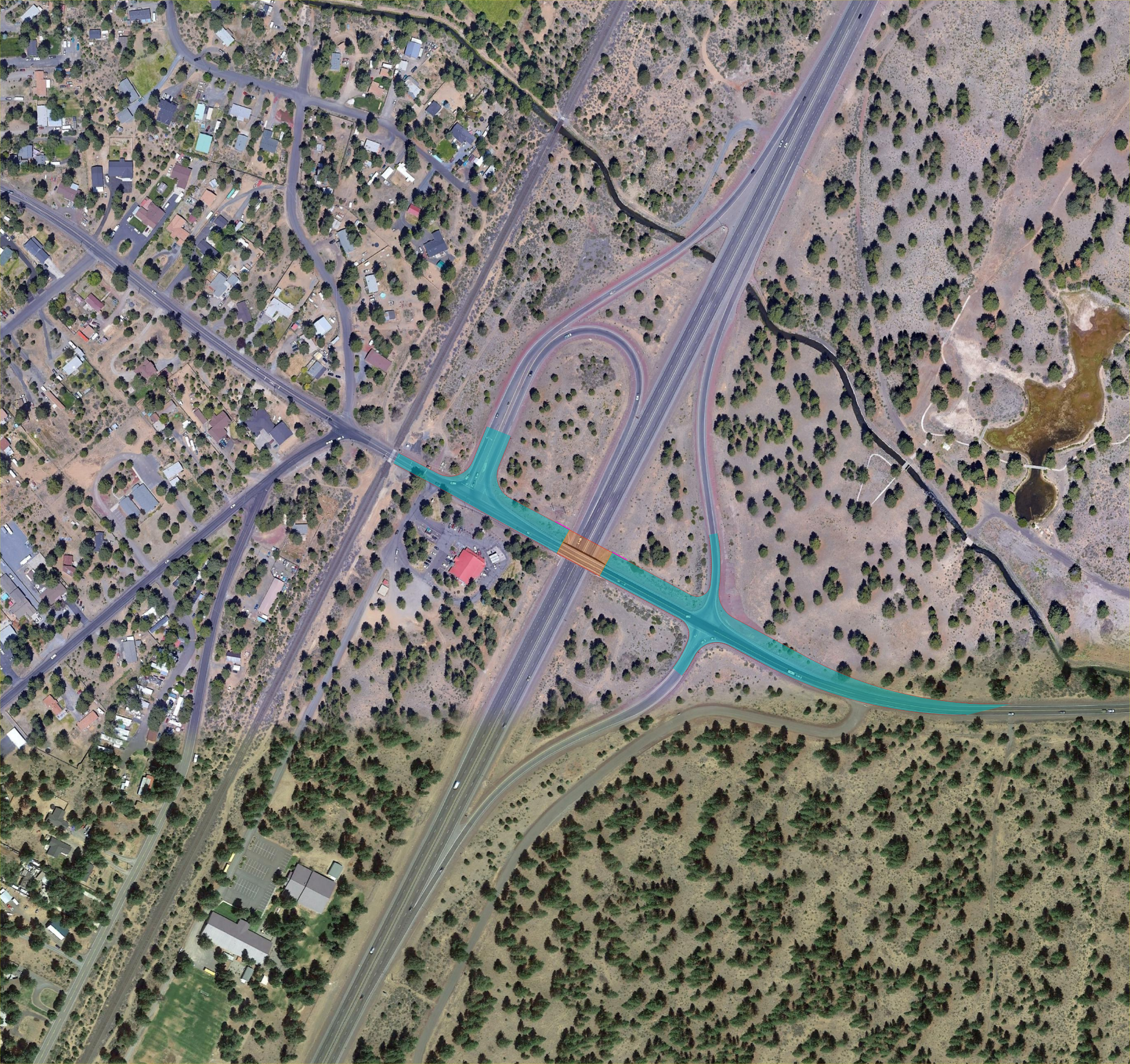 (Alternative 1. Click to enlarge.)
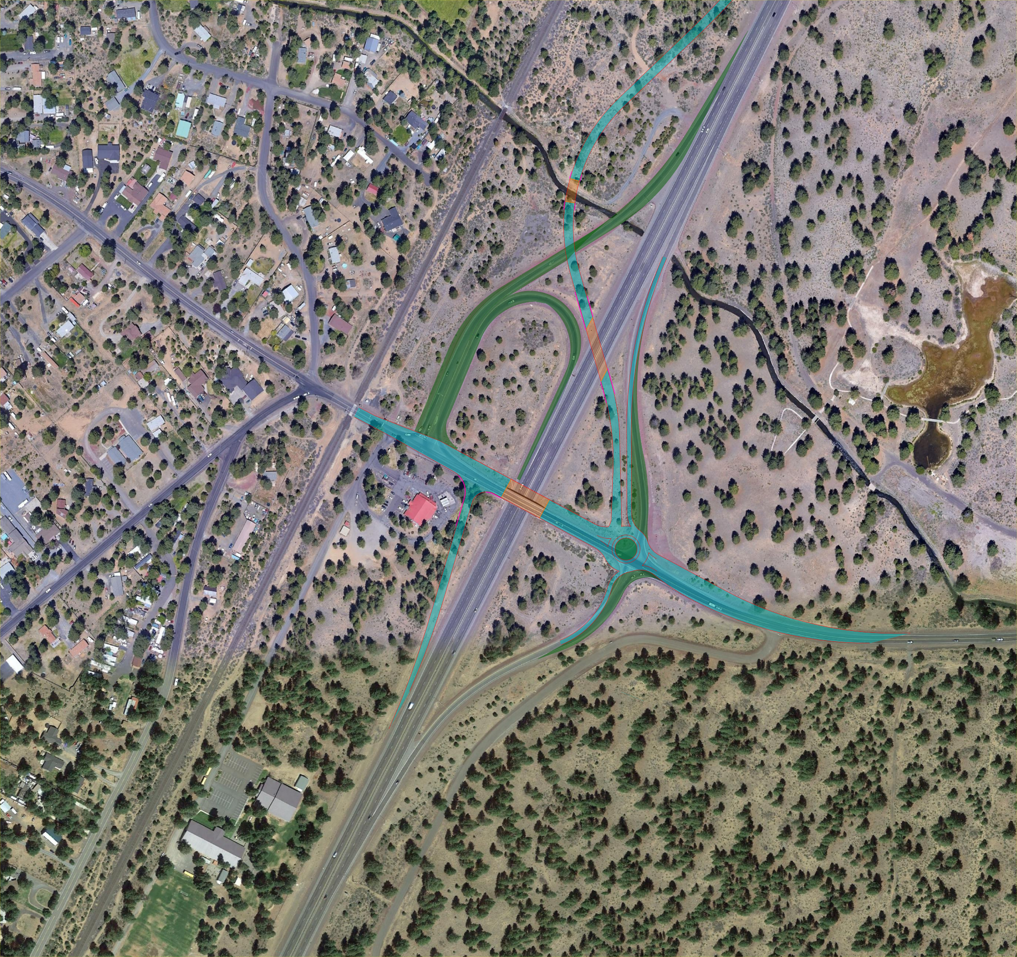
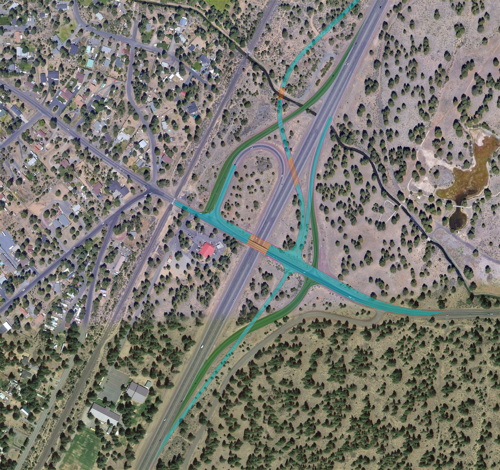
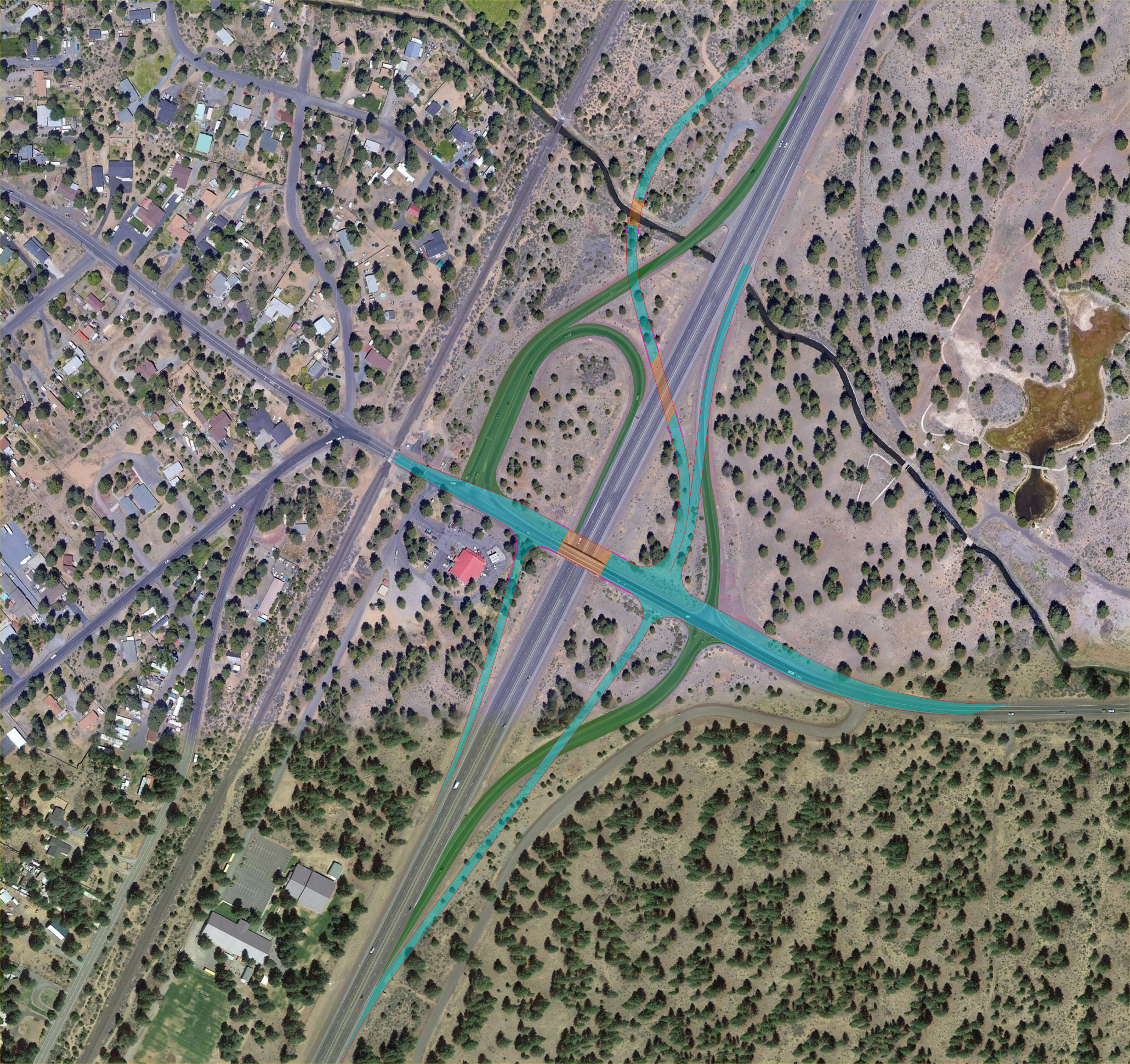
Alternative 2 – Tight Urban Diamond Interchange
Reconstruct the southbound on and off ramp by removing the existing loop ramp and realigning the existing southbound off ramp.
- Widen existing structure
- Construct eastbound and westbound left turn lanes at ramp terminals
- Provide raised multi-use path adjacent to eastbound travel lane
- Buffered bike lane adjacent to westbound travel lane
- Construct new retaining walls
- Reconstruct southbound ramp terminal
- Remove loop ramp
- Construct new southbound on ramp and retaining walls
- Will require retaining walls to minimize right of way impacts
- Intersection improvements at northbound ramp terminal
- Add capacity
- Additional turn lanes
- Potential new traffic signals
- Add capacity
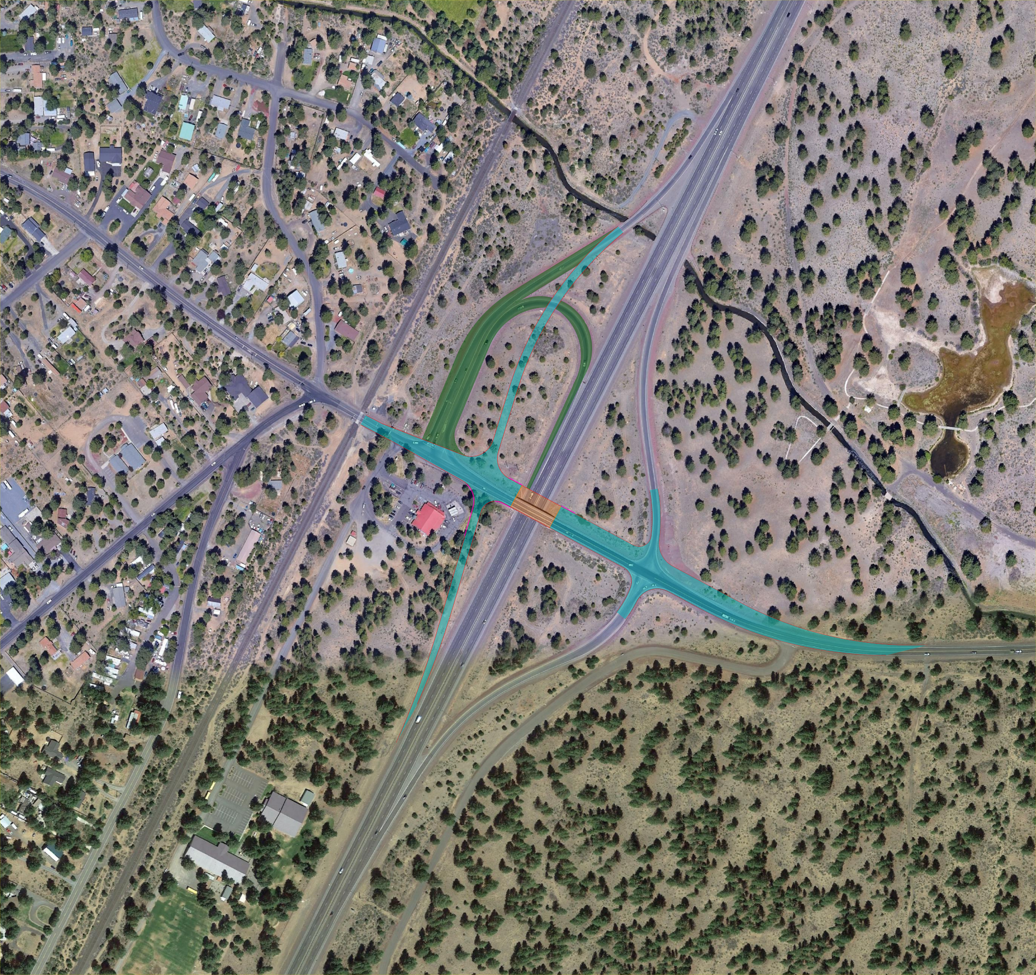 (Alternative 2. Click to enlarge.)
Alternative 3 – Southbound On and Off Ramp Flyovers with Signalized Intersection
Reconstruct the southbound on and off ramp by removing the existing loop ramp and realigning the existing southbound off ramp.
- Widen existing structure
- Construct eastbound and westbound left turn lanes at ramp terminals
- Provide raised multi-use path adjacent to eastbound travel lane
- Buffered bike lane adjacent to westbound travel lane
- Construct new retaining walls
- Construct new southbound on and off flyover ramps
- Remove existing southbound on and off ramp
- Construct new bridges over US 97
- Construct new bridge over channel
- Construct retaining walls
- Construct new intersection on east side of US 97
- All on and off ramps will go through one signalized intersection
Provides an increase in distance between US 97 southbound ramp terminals existing railroad at-grade crossing
 (Alternative 3. Click to enlarge.)
Alternative 4 – Southbound On and Off Ramp Flyovers with Roundabout Intersection
- Widen existing structure
- Construct eastbound and westbound left turn lanes at ramp terminals
- Provide raised multi-use path adjacent to eastbound travel lane
- Buffered bike lane adjacent to westbound travel lane
- Construct new southbound on and off flyover ramps
- Remove existing southbound on and off ramp
- Construct new bridges over US 97
- Construct new bridge over channel
- Construct retaining walls
- Construct new intersection on east side of US 97
- All on and off ramps will go through one single lane or multilane roundabout
- Provides an increase in distance between US 97 southbound ramp terminals existing railroad at-grade crossing
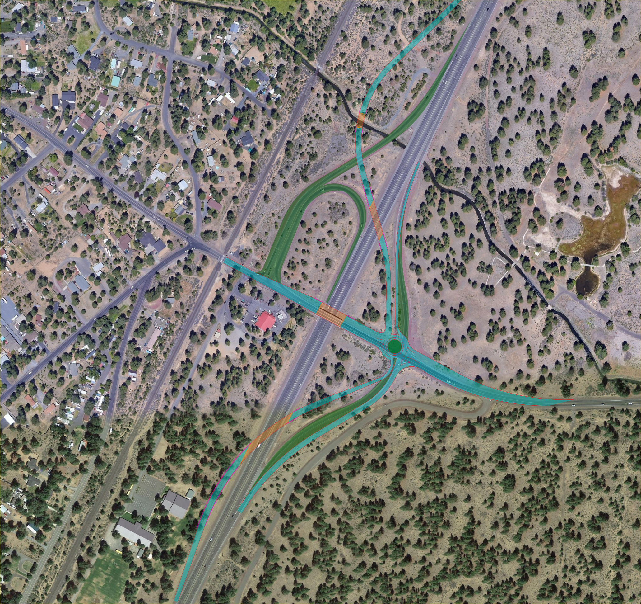 (Alternative 4. Click to enlarge.)
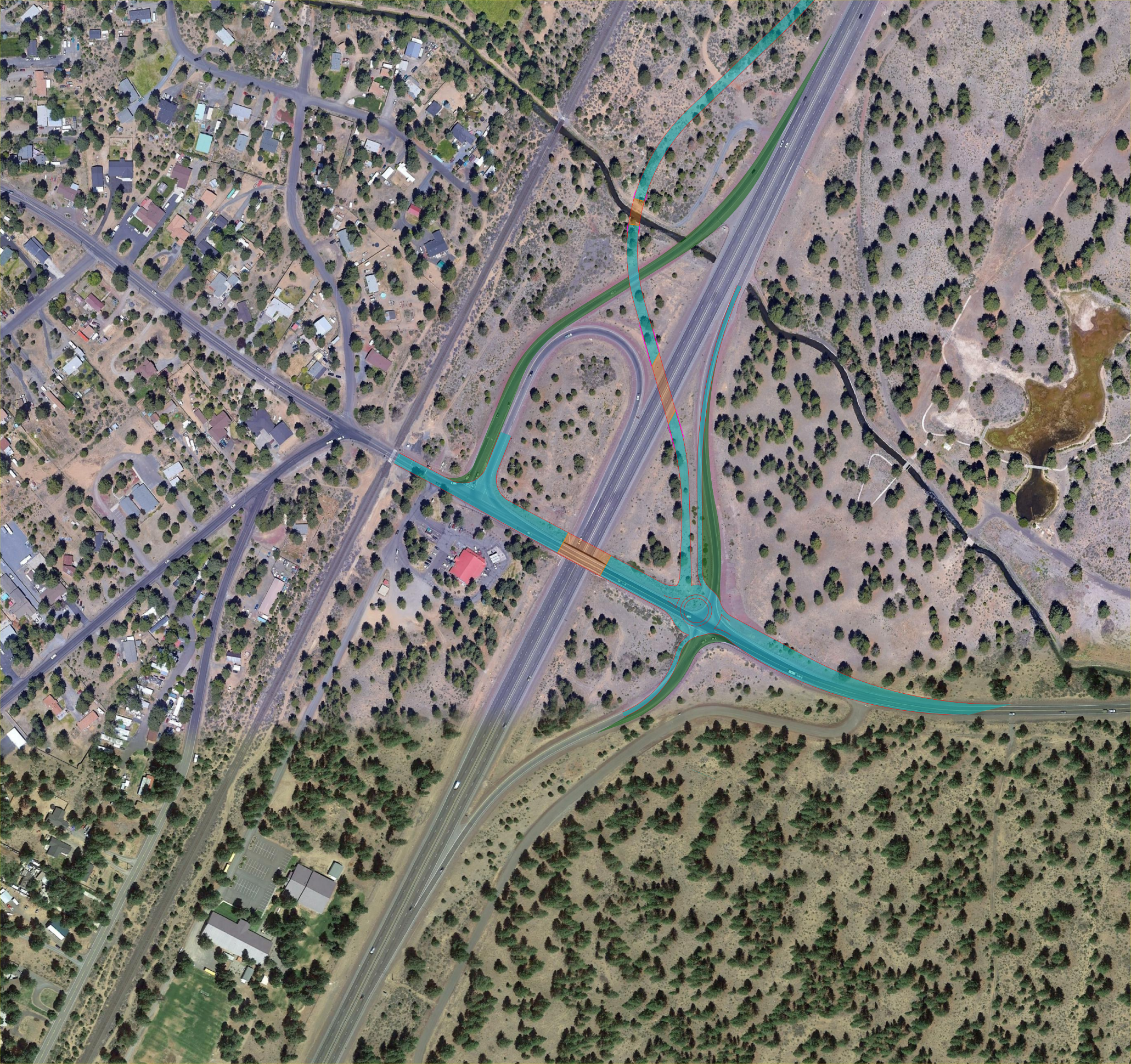
Alternative 5 – Southbound Off Ramp Flyover with Signalized Intersection and Existing Southbound Loop On Ramp
- Widen existing structure
- Construct eastbound and westbound left turn lanes at ramp terminals
- Provide raised multi-use path adjacent to eastbound travel lane
- Buffered bike lane adjacent to westbound travel lane
- Construct new southbound off flyover ramps
- Remove existing southbound off ramp
- Construct new bridge over US 97
- Construct new bridge over channel
- Construct retaining walls
- Construct new intersection on east side of US 97
- All off ramps will go through one signalized intersection
- Maintain existing southbound loop ramp
 (Alternative 5. Click to enlarge.)
Alternative 6 – Southbound Off Ramp Flyover with Roundabout Intersection and Existing Southbound Loop On Ramp
- Widen existing structure
- Construct eastbound and westbound left-turn lanes at ramp terminals
- Provide raised multi-use path adjacent to eastbound travel lane
- Buffered bike lane adjacent to westbound travel lane
- Construct new southbound off flyover ramps
- Remove existing southbound off ramp
- Construct new bridge over US 97
- Construct new bridge over channel
- Construct retaining walls
- Construct new intersection on east side of US 97
- All off ramps will go through one roundabout intersection
- Maintain existing southbound loop ramp
 (Alternative 6. Click to enlarge.)
Alternative 7 – Southbound Off Ramp Flyover with Signalized Intersection and New Southbound Diamond On Ramp
- Widen existing structure
- Construct eastbound and westbound left turn lanes at ramp terminals
- Provide raised multi-use path adjacent to eastbound travel lane
- Buffered bike lane adjacent to westbound travel lane
- Construct new southbound off flyover ramps
- Remove existing southbound off ramp
- Construct new bridge over US 97
- Construct new bridge over channel
- Construct retaining walls
- Construct new intersection on east side of US 97
- All off ramps will go through one signalized intersection
- Construct new southbound diamond on ramp
- Construct new retaining walls
- Will require retaining walls to minimize right of way impacts
- Mitigates concern for vehicles queuing back to the existing railroad intersection
- Construct new retaining walls
 (Alternative 7. Click to enlarge.)
Alternative 8 – Southbound Off Ramp Flyover with Roundabout Intersection and New Southbound Diamond On Ramp
- Widen existing structure
- Construct eastbound and westbound left turn lanes at ramp terminals
- Provide raised multi-use path adjacent to eastbound travel lane
- Buffered bike lane adjacent to westbound travel lane
- Construct new southbound off flyover ramps
- Remove existing southbound off ramp
- Construct new bridge over US 97
- Construct new bridge over channel
- Construct new intersection on east side of US 97
- All off ramps will go through one roundabout intersection
- Construct new southbound diamond on ramp
- Construct new retaining walls
- Will require retaining walls to minimize right of way impacts
- Mitigates concern for vehicles queuing back to the existing railroad intersection
- Construct new retaining walls