
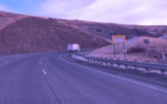
Overview
Key corridor challenges and characteristics include:
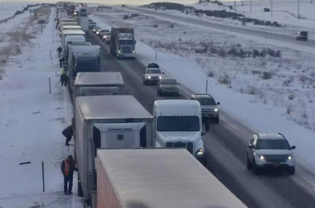
- History of severe crashes and extended closures
- Harsh weather conditions (snow, ice, fog, blowing dust), which are a cause of approximately 60% of crashes along the corridor
- Average daily traffic along the corridor ranges from 8,000 to 14,000, with up to 50% heavy vehicle traffic
- Varying terrain – curvy mountain passes to narrow canyons
- Rural and remote areas with long stretches between services (gas, lodging, and food)
- Limited cell service
- Limited power and communications to support intelligent transportation system enhancements (cameras, weather stations, electronic message boards, etc.).
Please visit each station to learn more about the individual projects:
(Numbers correspond with stations below.)
Stations

Snow Zone Elements
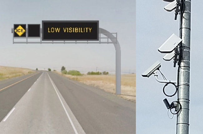
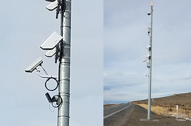
Electronic Message Sign – Weather Warning Messages, Weather Station with CameraWeather Warning EMS - The primary intent of these signs is to provide real-time weather information to drivers, allowing drivers to adjust behavior for the conditions. Sign use is versatile. When weather conditions are not present, it can be used for general purpose traveler information. In the future they may be used to display speed limit information, similar to the Baker Valley system. Weather Station with Camera - The weather stations include devices to detect temperature, visibility, and pavement grip factor (traction). The electronic message signs will be able to display information obtained from the weather station. Some weather stations will be equipped with a camera that will connect to ODOT’s system. Camera images can be viewed by both ODOT staff internally, as well as the public through ODOT’s TripCheck website. |
 |
|
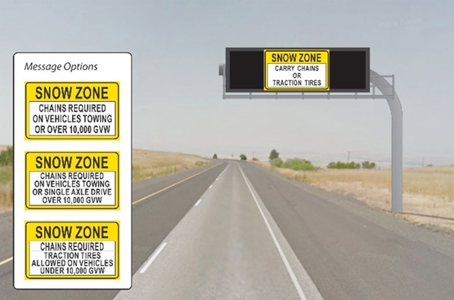
Electronic Message Sign – Chain-Up InformationThe primary intent of these signs is to provide chain-up information to drivers. These replace the outdated rotating “drum” snow zone signs. Sign use is versatile. When chain-up information is not necessary, it can be used for general purpose traveler information. |
 |
|
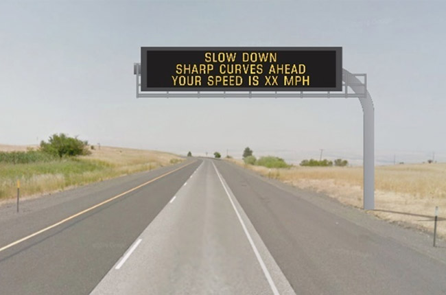
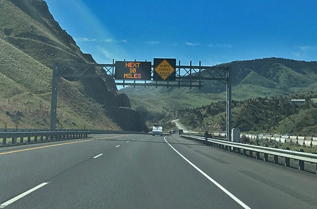
Electronic Message Sign – Curve WarningThese electronic message signs warn drivers of sharp curves ahead and provide information to the driver about their speed. |
 |
|
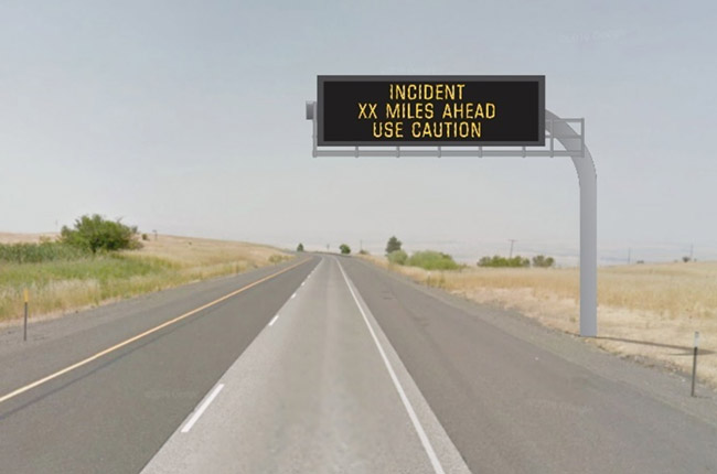
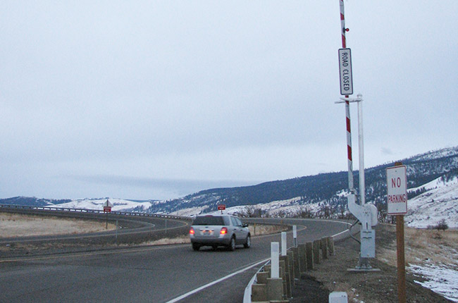
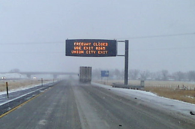
Electronic Message Sign – General InformationThis sign can be used to provide real-time traveler information to drivers, allowing drivers to make informed decisions. Examples of displayed information may include crashes, closures, fires, construction, and other information that may impact driver decisions. |
 |
|
Weather station with cameraThe weather stations include devices to detect temperature, visibility, and pavement grip factor (traction). The electronic message signs will be able to display information obtained from the weather station. All weather stations will be equipped with a camera that will connect to ODOT’s system. Camera images can be viewed by both ODOT staff internally, as well as the public through ODOT’s TripCheck website. |
 |
|
Curve Warning Signs with Flashing BeaconsThe curve warning signs alert drivers of upcoming curves. In particular, in areas with no roadway lighting these signs improve roadway delineation during compromised visibility conditions (dusk, nighttime, fog, etc.). The flashing beacons will be solar powered. |
||
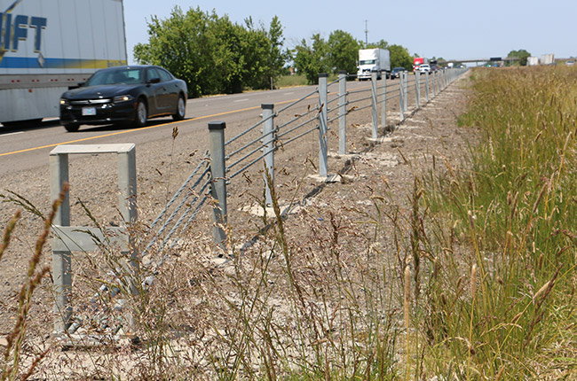
Cable BarrierCable barrier prevents vehicles from crossing over the median into wrong way traffic. |
 |
|
Prep Work for Future LED Roadway LightingLED roadway lighting provides improved visibility during non-daylight conditions. The project will eventually install 20 LED roadway lights along two miles of the westbound Cabbage Hill segment. |
 |
|
Automated Ramp GateAutomated ramp gates allows for ODOT staff to remotely close the on-ramp during inclement weather when the interstate closes. This provides staff efficiency, allowing staff to focus on clearing the roadway and opening it faster. It also reduces the number of vehicles entering hazardous conditions and the likelihood of a resulting crash, which increases the duration of a closure. |
 |
|
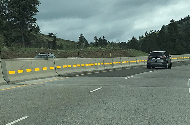
Reflective MarkersInstalling reflective markers improves roadway visibility, especially during impaired visibility conditions and when lane lines are covered with snow. |
 |
|
Buried Power LinesAdding power allows ODOT to install and operate intelligent transportation system (ITS) devices along the corridor. |
Truck Chain-Up Areas
Over a half-dozen truck chain-up or chain-off areas along I-84 snow zones have been added or enhanced in the past several years between Pendleton and Ontario. Specific chain sites for commercial trucks include the following locations.
- Mission Interchange EB (MP 216.4 to MP 216.9)
- Cabbage Hill WB (MP 217.3 to MP 217.9)
- Poverty Flats WB (MP 224.6 To MP 225.7)
- Poverty Flats EB (MP 226.3 To MP 237.4)
- Meacham EB (MP 237.2 To MP 237.7)
- Mount Emily WB (MP 245.2 to MP 245.7)
- Spring Cr. WB & EB (MP 249.2 to MP 249.7 )
- 5 Point Cr. WB & EB (MP 253.5 To MP 253.8)
- West La Grande WB (MP 259.9 to MP 260.3)
- Ladd Marsh EB (MP 265.7 To MP 266.7)
- Clover Cr. Interchange WB (MP 279.1 To MP 280.4)
- Baker City WB & EB (MP301.0 To MP 302.0)
Additional Freeway Truck Climbing Lanes
Short sections of new freeway lanes are being added along steep grades where slow moving trucks can create congestion, especially during winter conditions. Jackknifed trucks that lose control on slick roadways can easily block two lanes, shutting down the eastbound or westbound freeways.
A third eastbound lane for trucks was constructed at Three-Mile-Hill near mile post 358, 20 miles west of Ontario in 2010. At Spring Creek Grade, 15 miles west of La Grande, a third lane for westbound trucks was constructed in 2015. In 2019 work will begin on the new third lane for EB trucks at Ladd Canyon seven miles east of La Grande between MP 271-273 (see station 4 for project information featured in this Online Open House website.)

Variable Message Signs (VMS) Reader Boards
VMS reader boards are one key tool used to provide immediate and up-to-the-minute highway advisories to motorists who may be entering an area that includes hazardous conditions such as ice, fog, or wreck ahead. Currently there are 20 digital VMS type signs located along the interstates in eastern Oregon.
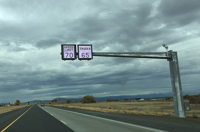
Variable Speed Limit Signs (VSLs)
One innovation to help reduce crashes along I-84 is the use of Variable Speed Limit signs that can lower the enforceable speed limit based on weather or road conditions. In the event of hazardous conditions such as ice, snow or fog, or a lane/road closure ahead, the speed limit can be lowered to help get drivers to slow down as the approach a hazard that may be a mile or more ahead. Variable Speed Limit signs were installed along a 30-mile stretch of I-84 between Ladd Canyon and Baker City in 2015. The new system is helping reduce the number and severity of crashes in this area when motorists experience weather pattern changes due to the proximity of the Blue, Elkhorn and Eagle Cap mountain ranges.

New Snow Fencing to Reduce Drifts/White-Outs
ODOT has been investigating and testing different types of snow fencing to improve winter driving conditions along the interstate and other highways where drifting snow can create winter driving hazards. Over the past two decades new snow fencing has been installed along several sections of I-84 between La Grande and Baker City, including log style fencing in Ladd Canyon and a vinyl slat style in the Baker Valley.
Roadway Realignments and Curve Warning Systems
Some sections of I-84 follow alongside winding rivers that cut natural pathways through eastern Oregon mountain ranges. The Burnt River Canyon south of Baker City is one such site where the curvy alignment of the freeway has contributed to crashes when vehicles are driving too fast for conditions. In 2006 ODOT realigned two 50 mph curves and added three new curve and speed related reader boards that have helped reduce crashes in this corridor. The upgrades include radar signs to warn motorists of their travel speeds, curve warning signs with flashing lights, and variable message signs that can display current conditions in the area.
Description
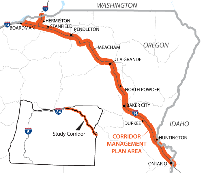
In early 2018 ODOT completed a corridor management study that evaluated over 200 miles of I-84 and I-82 in eastern Oregon. The study extended between Boardman and Ontario, seeking to find transportation system management and operations (TSMO) solutions to improve safety and operations along the two interstate routes. TSMO strategies focus on improving safety and performance of existing infrastructure rather than building additional capacity, and tend to be lower cost than capital infrastructure projects. For example, instead of building additional lanes, a TSMO strategy improves the safety and operations of the existing lane miles by incorporating communications, technology, and cross jurisdictional coordination.
Process
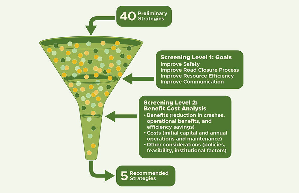
Throughout the project, ODOT worked with a broad range of stakeholders across the region to gain insight on a variety of user needs and priorities along the corridor, as well as developing four key project goals:
- Improve SAFETY for all I-84 and I-82 corridor users
- Improve COMMUNICATION along the corridor
- Improve ROAD CLOSURE process and reduce impact for all users
- Improve RESOURCE EFFICIENCY
The project team evaluated nearly 40 strategies with potential to improve safety and operations along the corridor. Through a collaborative screening process and a benefit cost analysis, five strategies emerged as the most promising ones to improve safety and operations along the corridor.
Corridor Map
Recommendations
The project team identified both near-term projects for immediate implementation, as well as projects to implement in the mid to longer term timeframe. The mid to long-term projects require developing some new systems and processes.


Description
The section of I-84 between Pendleton and La Grande is plagued with some of the highest crash rates and frequency along the corridor, making the segment a priority for improvement. This project advances some of the recommendations from the Corridor Management Plan (described in Station 2). It focuses on the section of I-84 between Pendleton and La Grande
Timeline
Design is underway and construction will take place in 2019 and 2020.
Funding
The project is currently funded at $11 million, with $4 million allocated from the 2017 Keep Oregon Moving Transportation Bill. Eastern Oregon was very fortunate to receive the extra funding support from our legislators. Without the bill, we wouldn’t be able to construct the number of safety improvements we have planned now and for future projects.
Construction Impacts
During construction it may be necessary to close one travel lane for brief periods and perform several rolling slowdowns, but no major impacts are expected.
Project Elements
| Over a dozen new electronic message signs to provide information about: | |
| Weather and roadway conditions, | |
| Chain-up conditions, | |
| Curve warning information, and | |
| General information that impacts the interstate such as crashes ahead, closures, or construction information. | |
| Ten new weather stations with sensors to detect pavement conditions and cameras to provide visual information to operators and travelers. | |
| A dozen curve warning signs with flashing beacons in the Grande Ronde River Canyon (west of La Grande). | |
| Nine miles of cable barrier between eastbound and westbound lanes at two locations to prevent cross over crashes (MP 229 - 238, and 249-250). | |
| Two miles of prep work for future LED roadway lighting along Cabbage Hill westbound curves (MP 221-223); 20 lights will be installed initially with additional illumination as funding allows. The LED illumination will help delineate the westbound lanes through the curves as you are driving down the hill. | |
| An automated ramp gate at the westbound on-ramp from Exit 224, allowing for faster closure during inclement conditions. This reduces the number of vehicles entering hazardous conditions, reduces the likelihood of a crash, and frees up staff resources to clear the roadway faster. | |
| Over a dozen miles of yellow reflective markers attached to guardrail in Cabbage Hill area. | |
| Over 10 miles of buried power line (to support these enhancements and future upgrades). | |
Map
Explore the project elements using the map below. Click on shapes and icons for more information and images. (Click to reset map.)
Description
The purpose of this project is to improve traffic flow and safety along the two-mile-long, 6 percent grade of I-84 through Ladd Canyon, and upgrade several culverts to improve fish passage for Ladd Creek and Brush Creek (which run adjacent to the freeway). The paving work includes slow lane resurfacing and expansion of fast lane shoulders between Ladd Canyon and La Grande to extend the useful life of the pavement and provide safer shoulder areas.
Key elements of this project:
- Replace the Interchange Bridge with a box culvert (reduces the likelihood of icy roadway conditions)
- Add a two-mile long eastbound climbing lane.
- Replace Ladd Creek box culvert
- Reroute Brush Creek.
- Abandon Brush Creek box culvert.
- Replace Brush Creek box culvert
- Repave a ten-mile section of eastbound and westbound slow lanes
- Widen a ten-mile section of fast lane shoulders
Timeline
The project will bid late summer 2018. Major construction activities will take place in 2019 and 2020.
Funding
The total cost of the project is estimated at approximately $20 million, with $3.4 million funded through the Keep Oregon Moving transportation bill (HB2017).
Construction Impacts
During construction, traveler can expect reduced speeds, minor delays, and lane restrictions. Bike and pedestrian access will also be prohibited between mile posts 270 and 273 during the 2019 construction period.
Benefits
Traffic safety and efficiency will be improved with the new third lane for eastbound trucks traveling up Ladd Canyon grade. This steep incline results in slow truck speeds as low as 10-15 mph throughout the year. Trucks passing one another on the grade currently block both eastbound lanes, causing back-ups for passenger vehicles traveling behind them. Winter time is more problematic. Ice, snow, and high winds, combined with the steep grade and sharp curve at the bottom of Ladd Canyon have given this section of freeway notoriety among travelers and the freight industry for being a treacherous section of road. Freeway closures in the area are often attributed to commercial vehicle spin outs and wrecks. The issue is a growing challenge as the number of commercial vehicles in the area has steadily increased over the years.
Fish Passage along Brush Creek and Ladd Creek will be improved through culvert upgrades and realignment of Brush Creek. Both streams were realigned during the freeway’s initial construction in the 1950s and 60s which eliminated fish passage beyond the project area. A project in 2015 addressed some of the major fish passage issues and the work in 2019 will complete these long awaited upgrades.
Map

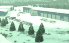
Description
ODOT’s Meacham Maintenance Station facility is the Agency’s home base for highway maintenance on Interstate 84 through the Blue Mountains between La Grande and Pendleton. Facility functions include maintenance vehicle dispatch, equipment servicing, minor repairs, material and tool storage, fueling, de-icing, stockpiling of road sand and salt, and crew areas.
ODOT has been planning for decades to invest in a replacement of the Meacham Maintenance Station. This investment, which will coincide with snow zone safety improvements on I-84, will improve highway maintenance response times on I-84, improve crew efficiency, reduce wear and tear on agency equipment, and save on energy costs.
The new facility includes:
- A 27,000 square foot primary maintenance building, with heated storage bays for critical rolling stock such as snow plows and light fleet, mechanic’s bay, storage for material and tools, equipment wash bay, and crew area
- A 6,700 square foot non-heated storage building for rolling stock and equipment that require covered storage, but not heat
- A 12,000 square foot membrane-covered storage bunker for ODOT’s road sand and salt products
- Fuel, de-icer, and other material storage
- A new radio tower at the highest elevation on the property to improve radio signal over the Blue Mountains for ODOT and other response crews.
Timeline
The new facility will break ground in Spring 2019. Construction will be completed in Summer 2020. The winter of 2020-2021 will be the first winter season that the ODOT crew will work out of the new facility.
FAQs

Architectural rendering of the new Maintenance Station. Courtesy Soderstrom Architects.
Map
The new facility will be located on the south end of the ODOT quarry at Old Highway 30 and Forest Service Road 3030, approximately 1/4 mile north of the existing maintenance station.
General Timeline
- Pre-2017: Several past safety improvement projects implemented including: truck chain-up areas, truck climbing lanes, variable message signs, variable speed limits, snow fencing, and roadway realignments/curve warning system.
- 2018: Corridor Planning Study completed
- 2019: Construction begins for the Snow Zone Improvement Project, Ladd Canyon Freight and Culvert Improvement Project, Meacham Maintenance Station.
- 2020: Construction activity completed for the three projects listed above.
- Beyond 2020: ODOT will continue to plan, design and construct safety improvements along the interstate system utilizing the Corridor Planning Study, safety data, new technologies and other tools.
Comments?
Please provide feedback using the form below.
For more information
- For information about the planning phase of the project, visit the project’s website at: i84safemobility.org/.
- For other ODOT Region 5 information and projects, visit: oregon.gov/odot/regions/pages/region-5.aspx.
- Contact: Tom Strandberg, Public Information Officer - ODOT Region 5
thomas.m.strandberg@odot.state.or.us or 541-963-1330